

CAPE
-
Posts
36,846 -
Joined
-
Last visited
Content Type
Profiles
Blogs
Forums
American Weather
Media Demo
Store
Gallery
Everything posted by CAPE
-
Its gonna be cold after Jan 1. Wonder if DT could advise me on the chances of this verifying. Thinking of heading to J-ville for a chase.
-
Not gonna see much 50-50 low action with a +NAO. 50-50 highs are going to be more likely. The currently advertised LR h5 pattern is pretty much the inversion of what we want to see. Is it correct? Who knows.
-
Not pretty. The +AO/+NAO/+EPO trifecta provides literally no mechanism for cold air delivery into the mid latitudes. Hopefully it is a temporary state, or the guidance is currently overstating that look.
-
Yeah it builds the NAO ridge week 4-5, so who knows how real that is. Looks somewhat positive/neutral before that. Hopefully the EPO ridge gets into a better spot, because I still have my doubts about a sustained NA block, and as you said without it we fight the tendency for SE ridging given the advertised the EPO location verbatim.
-
Agreed. If the CFS actually has a clue, I would be ok with what it's advertising overall, with an EPO ridge and a mostly neutral AO/NAO look, and a piece of the TPV on our side, although not necessarily in an ideal spot. This look would be acceptable for mid-late Jan:
-
Beginning right around the new year continues to look potentially active, with at least somewhat colder air in place. 6z GEFS upped the game a bit. First week of Jan has what looks to be multiple waves tracking just to our south. Rolling through the p-type panels for that period is a fun exercise, and it is also reflected on the snowfall mean.
-
Glancing at the 0z means, looks like straight up blue across the top at h5 in the LR. +EPO/+AO/+NAO. The hints of a building EPO ridge from previous runs are gone for now(or delayed). Despite that, we manage at least seasonable cold, as advertised. Likely some IOD/MJO 'conflicts' still playing into the currently advertised pattern evolution beyond day 10.. The latest CFS weeklies look pretty nice weeks 2-6. Active look week 2, and general cold beyond that with a -EPO, and even hints of a -NAO week 5.
-
Yeah probably a good reason to keep our sights on the day 10 period- Interesting enough looks on the EPS and the GEFS for around the New Year, and beyond that is probably more muddled than usual.
-
I don't hate that look at all.
-
Its not a bad look in the LR on the mean, but realistically the h5 pattern won't look like that, as there is quite a bit of spread on the individual members. Verbatim the mean looks cold for much of the lower 48, but its likely due to disagreement among the members on location of the main features. We are not likely going to see low h5 height anomalies covering most of the Continental US as depicted towards the end of the run.
-
I have been busy having fun and not paying a lot of attention to the LR big picture the past few days(a good thing) but there is a lot of good stuff happening here.
-
I just made a post, and the thread showed that I made the most recent post, but its not showing up. Something is effed up.
-
I am right in that hole over the upper Delmarva. No rain here in 2 weeks. Been running the sprinkler but grass still getting torched. Oh well, pretty used to it, as the rain we get this time of year is of the feast/famine variety. With the high sun and typical July heat, my yard cant survive without water for more than a few days.
-
Noticeably dry here in the past week. Soil getting a bit dusty for the first time in months. I think the last big event was a couple weeks ago with the 2 part deal in late March- mostly rain/sleet here for part one and the heavy wet snow for part 2. Been really nothing significant since then. 0.11" for April.
-
Yeah the biggest issue with winter drought for most in this forum is it = little snow lol
-
Cant imagine its still abnormally dry here, but I guess its possible. I ended up with 3.8" for Jan.
-

Southern MD / Lower Eastern Shore weather discussion
CAPE replied to AnEndlessMaze's topic in Mid Atlantic
Was that the total for the whole event? I saw some reports from southern DE of up to 7" from Friday night alone. I would love to see some other event totals from the lower Delmarva. -
Southern MD / Lower Eastern Shore weather discussion
CAPE replied to AnEndlessMaze's topic in Mid Atlantic
You might get another 3-6 today. -
Southern MD / Lower Eastern Shore weather discussion
CAPE replied to AnEndlessMaze's topic in Mid Atlantic
Another 20-30 miles NW and I am in the bullseye I sincerely hope SBY and the beaches get 6"+. I had such a great time at Rehoboth for that cold powder bomb in early Jan. -
Southern MD / Lower Eastern Shore weather discussion
CAPE replied to AnEndlessMaze's topic in Mid Atlantic
Here are some official totals from Mount Holly for the 1/7 storm for southern DE- ...SUSSEX COUNTY... OCEAN VIEW 13.5 625 PM 1/07 TRAINED SPOTTER SELBYVILLE 13.0 604 PM 1/07 TRAINED SPOTTER SEAFORD 9.0 550 PM 1/07 TRAINED SPOTTER LAUREL 8.0 538 PM 1/07 DEOS ELLENDALE 6.6 537 PM 1/07 DEOS 7 E SELBYVILLE 6.5 600 AM 1/08 COCORAHS STOCKLEY 6.2 537 PM 1/07 DEOS BRIDGEVILLE 6.1 538 PM 1/07 DEOS 1 W MILLSBORO 6.1 800 AM 1/08 COCORAHS BLADES 6.0 545 PM 1/07 TRAINED SPOTTER NASSAU 5.8 600 PM 1/07 DEOS I was in Rehoboth and there was unofficially 10" there for the 1/7 event. Lewes I thought I saw a report of 12" somewhere. I don't have any official totals for the 1/30 event, but I know there was a 2-4" area in southern DE for that one. Hope this helps! -
Southern MD / Lower Eastern Shore weather discussion
CAPE replied to AnEndlessMaze's topic in Mid Atlantic
That one storm made this wretched winter bearable. Who would have thunk it- the best pure snow event of the season for our region occurred at the beaches. Cold dry powder with drifting too. I had 2 great days at Rehoboth, then came home to 6" on the ground and that stuck around for 3 more days. I got a nice snow hike in at Tuckahoe. Good 5 day stretch of winter, and in early January to boot. But that was all she wrote. -
Southern MD / Lower Eastern Shore weather discussion
CAPE replied to AnEndlessMaze's topic in Mid Atlantic
Nope. 1.2" here. Hoping to see some reports from Delaware. Best banding has persistently been in Sussex County. Must be some 4' amounts there. -
Southern MD / Lower Eastern Shore weather discussion
CAPE replied to AnEndlessMaze's topic in Mid Atlantic
Rehoboth is completely awesome. No official measurement but definitely 8+ with lots of drifts. Winter wonderland at the beach plus bar hopping. So fun. -
Southern MD / Lower Eastern Shore weather discussion
CAPE replied to AnEndlessMaze's topic in Mid Atlantic
Took these out in front of the hotel in Rehoboth.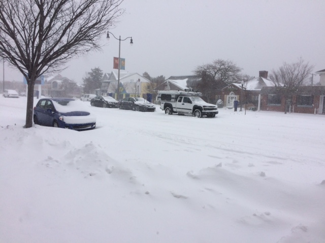
-
Southern MD / Lower Eastern Shore weather discussion
CAPE replied to AnEndlessMaze's topic in Mid Atlantic
Looking pretty good. Root for the NAM of course lol. Even if it is overdone, almost all other guidance has at least a few inches down your way and over to the beaches.


