
CAPE
-
Posts
34,073 -
Joined
-
Last visited
Content Type
Profiles
Blogs
Forums
American Weather
Media Demo
Store
Gallery
Everything posted by CAPE
-
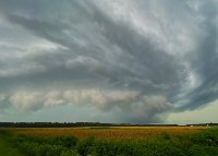
Mount Holly is a tad bullish on the severe threat- mostly for damaging straight line winds... The main concern for severe weather looks to be for the very late evening and especially overnight as forecast models continue to indicate a strong squall line forming to our west ahead of a cold front and moving west to east across the CWA roughly in the 6-10z time frame. Overall, severe weather parameters are some of the most favorable seen for the mid Atlantic this time of year. 0-1/0-3/0-6 km shear values look to be 30/45/65 knots respectively. This, coupled with ML CAPE values looking to be 500+ j/kg as convection enters our eastern PA zones. Not terribly impressive on its own but plenty given the very strong shear and dynamics along with L57 lapse rates that look to be in the 6.0 to 6.5+ C/km range. Of additional concerns is 0-1 km SRH values progged to be 300+ m2s2. What this all means is that damaging winds look to be a big concern as this squall line moves through with the SPC having placed an enhanced risk for severe weather for a large portion of the CWA except the coast and far northern NJ. In technical terms, a QLCS type event. Damaging straight line winds are typically the biggest threat with these types of events but given the parameter is place, isolated tornadoes are possible. In addition, the very heavy rain accompanying the showers/storms will bring a good potential for at least urban, small stream, and poor drainage type flooding with isolated flash flooding also possible.
-
yeah, it says "a" tornado. Possibly the only thing more fruitless than tracking snow in this region, is tracking severe. lol.
-
High temp forecast busted big time today, but it is juicy out there. Predicted high was 77. Made it to 69. Currently 66/65.
-
Heavy rain threat is pretty decent tonight along I-95. WPC has a marginal risk for excessive. From Mount Holly AFD for this evening into the overnight: We have concerns for heavy rainfall with this second round of showers and embedded storms. PWATs should rise to 1.5 inches in the warm sector as moisture is drawn northward with a few hundred j/kg of elevated CAPE being shown by models. Also, the south/east progression of the front should slow down with the mean flow running nearly parallel to it. So for these reasons not only will heavy rainfall be a concern but also the potential for training of heavier shower/storms in a SW to NE orientation. So this all said, urban and and small stream type flooding looks to still be a threat overnight as localized rainfall amounts of 1-2 inches will be possible within just a few hours.
-
Pretty intense looking line over Dorchester county with a warning.
-
Ended up hitting here. Nice 15-20 min downpour with a couple cracks of thunder. Picked up 0.23". Nice little drink for my parched soil. Weeds were struggling, lol.
-
Dark skies and rumbling just to my west. Relatively small cell so odds are it will miss. As expected most of the good stuff firing to the south.
-
DP here is 62. But even here I suspect the drier air will work in, limiting convection. Looks like areas just to my south might get some decent t-storms though.
-
Just hit 0.5" of rain. 37 here. woop! Congrats to the NW'ers getting the snow. Sorry for those on the edge, getting cold rain and sleet, but you probably knew deep down what was likely coming. Goodnight y'all.
-
Maybe a few mangled flakes mixed in here? If not, at least my rain will be colder lol.
-
But wait, Jayyyy had heavy snow with snow covered roads in EC.. a veritable blizzard.
-
They were pretty low to begin with, outside of places NW of Philly.
-
Just light stuff here now, but at least my temp is down to 36.5. Looks like I am primed for some 34 and rain tonight!
-
Yeah, go back!! Screw obligations and stuff. We talking snow here.
-
As if he has a clue, lol.
-
Radar looks very impressive here. Problem is, its 39. More heavy rain, lol. (at least its not 33 and rain, yet)
-
Light rain here and 44. That's 5 degrees above the forecast high. Be surprised if I see a few mangled flakes or sleet pellets.
-
Ha maybe! I know very little about the physics of the HRRR. What I do know its it is prone to dramatic shifts over a few runs, and it is next to useless beyond 3-4 hours. So I guess what I am saying is, I wouldn't worry about that particular model. There are enough subtle changes in the more reliable guidance over the past 2-3 model cycles to put up some caution flags though. Just for a "quick and dirty" look, check out the snow map over last 3 runs of the GFS on TT. Don't look at the amounts, just the trend. It now has all the significant snow focused more NW, as expected in this setup. I said yesterday I thought the ICON looked reasonable, and it has pretty much held.
-
Just looked at the HRRR for the first time. Not too inspiring lol. Of course, it's the HRRR.
-
Admittedly I don't have a whole lot of interest at this point, but I skimmed through the guidance this morning, and other than maybe the Euro, everything looked a bit warmer to me. Likely won't make much difference far N and W, but around I-95 it will. After the initial onset of precip, which will likely be rain, the best chances for places like DC to pick up an inch or 2 is clearly this evening, when rates pick up and some dynamic cooling occurs. Beyond that, warming aloft will be moving in from the SE, and with surface temps probably just above freezing, p-type will transition to more of a sleet/rain mix for I-95 and points SE.
-
Who cares. The 12km pummels me in death. Thanks Reaper!
-
I have 6 acres, and where the house is located is "high" and the soil is well drained. My driveway is a mess though, and there is a wetland back in the woods. Mosquito breeding ground in Spring.
-
Might be a little on the light side, but temps are a factor. Definitely a more realistic look than the 12Km NAM.
-
I just hope my yard sees the precip hole that has managed to occur every time it snows this year. I really don't need another inch of rain.
-
The 18z ICON looks pretty reasonable to me. Has the heaviest snow NW where expected, and the snow maps seem indicative of lower ratios given the marginal temps.


