
CAPE
-
Posts
34,073 -
Joined
-
Last visited
Content Type
Profiles
Blogs
Forums
American Weather
Media Demo
Store
Gallery
Everything posted by CAPE
-
Yep. Pretty safe bet.
-
lol this probably explains it. I mean, none of these super LR forecasts are ever very good, but that really looked completely whacked out.
-
Yeah its fun to look at. It literally has HL blocking straight through until April, and the EPAC looks generally very favorable. The NAO has maintained a negative phase overall for a while now, so who knows. Based on recent years though, during the winter months, we clearly know better.
-
CanSIPS is jacked up for some winter in the east.
-
The current solar cycle should be at or close to minimum heading into winter, so there's that!
-
Last 2 weak Nina winters(16-17, 17-18) had the big early January beach snowstorms. Let's do that again.
-
This might be the best T&L show of the summer here. And as a bonus, I gotz rain! 0.55" so far.
- 2,802 replies
-
- 1
-

-
- severe
- thunderstorms
- (and 4 more)
-
Radar really blossoming just to my south and west. Hopefully even the leftover crumbs will add up to a half inch or so. That initial cell was really noisy and impressive electrically, but the heavy rain passed to my SW. Picked up a tenth of an inch.
-
Tons of lightning and booming thunder here now. Will significant rain actually fall? Probably less than a 50% chance based on outcomes over the last couple weeks here.
-
Some moderate rain falling here now. As expected, the best stuff is south of DC, especially down in the tidewater of VA.
-
Some of the folks here are like my dad sometimes. "It's not gonna rain.. there is nothing showing on radar anywhere close!". Ofc, he is not a weather hobbyist and does not understand concepts like surface convergence/upper level divergence, vorticity max, etc.
- 2,802 replies
-
- 1
-
-
- severe
- thunderstorms
- (and 4 more)
-
LOL. Question answered!
- 2,802 replies
-
- 1
-
-
- severe
- thunderstorms
- (and 4 more)
-
This might be a dumb question, but why would reaching the convective temp be critical when the synoptic setup provides mechanism(s) for lift? We have a front, with upper level perturbations moving through. Seems reaching the convective temp would be much more important when there is little to no forcing available, as with typical summer air mass storms.
- 2,802 replies
-
- 1
-
-
- severe
- thunderstorms
- (and 4 more)
-
It's so pitiful it cant be found.
-

2019 Mid Atlantic Lawn, Garden, Pool, etc. Thread
CAPE replied to Eskimo Joe's topic in Mid Atlantic
Finally got around to actually building a firepit to go with the surround I did back in the Spring. I built a couple planter boxes to put trees in, and I will make a bench once I figure out exactly what I want.- 309 replies
-
- 12
-
-
Plenty of sun here this morning. Still feels pretty decent out there, although the dewpoint is creeping up. currently 79/64.
-
Some excerpts from this morning's AFD from Mount Holly on the potential for late today into the evening- A third perturbation arrives late today, and this is the one that should produce stronger convection. There are two main forecast questions associated with this perturbation. Where will it track, and how will the downstream environment destabilize? Regarding the first question, the 00z NAM tracks it along the Mason-Dixon Line. The 00z GFS tracks it across northern Virginia eastward to Delmarva. The 00z ECMWF is much farther north (generally through PA/NJ). These differences are critical because convection will likely develop in close proximity to this vort max. Hi-res models are similarly variable, with HRRR runs developing strong convection anywhere from eastern PA/central NJ to central/southern MD eastward through Delmarva. Where the environment remains relatively unperturbed by the predecessor precipitation/clouds, BUFKIT soundings show MLCAPE approaching 1000- 1500 J/kg this afternoon in an adequately sheared (30-35 kts deep- layer bulk wind difference) environment. Low-level helicity will also improve through the day, with hodographs exhibiting modest curvature (0-3 km SRH approaching 150 J/kg by evening). Where convection develops, mixed convective modes may occur initially with all types of severe possible, though convection-allowing guidance is tending to develop a mesoscale convective system rather quickly. Timing of the stronger storms looks to be after 3 pm and may peak during the evening hours based on the latest HRRR/NAM Nest simulations.
-
Mount Holly's take this morning on the active upcoming period and severe potential for Sunday and esp Monday for most of our region. The aforementioned cold front will be approaching the lower Great Lakes east-northeast to northern/central New England on Sunday, with several weak perturbations moving west-to-east near the boundary. Convection should readily develop along/downstream of the front by afternoon, mainly to our north/west but probably also in our CWA as well. The 00z GFS is depicting a stronger vort max approaching the northern Mid-Atlantic during the evening, with a round of strong/widespread convection in our area by this time. The 00z ECMWF is fairly similar, which provided enough confidence to raise PoPs to high-chance and even likely in northern portions of the CWA Sunday afternoon/night. Precipitation will wane late Sunday night as nocturnal stabilization takes over and the strongest large-scale lift moves to our east. The CAPE/shear parameter space would be sufficient for severe storms Sunday afternoon/evening, and I am rather concerned the GFS is underdoing instability in the pre-frontal warm sector given increasingly warm/moist conditions. Moreover, BUFKIT soundings/hodographs suggest a substantial amount of low-level shear/helicity may exist. Will need to watch Sunday afternoon/night closely for the severe-weather threat in the coming days. After perhaps a brief reprieve late Sunday night into Monday morning, chances of strong convection return Monday afternoon. Both the 00z GFS and ECMWF depict another strong perturbation moving through the northern Mid-Atlantic during the afternoon/evening. Once again, the CAPE/shear parameter space is favorable for severe storms, though shear may be somewhat weaker than the previous day. However, the pre-frontal warm sector may be more unstable (using model sounding comparisons Sunday versus Monday). Complications from antecedent convection will exist (increasing the uncertainty in the forecast by this point), not to mention the model volatility already in place with the perturbations responsible for the larger-scale lift associated with the convection. Nevertheless, I am becoming quite concerned with the severe threat both of these days, and hydro issues will be an increasing concern as well given the multiple rounds of storms that may affect the area.
- 2,802 replies
-
- 2
-
-
- severe
- thunderstorms
- (and 4 more)
-
Yeah some of the meso runs had this, but I was skeptical. I am over 7" for May now.
-
Round 2 has arrived. Nothing severe, but looks like there could be some persistent(training?) cells. Torrential rain currently.
-
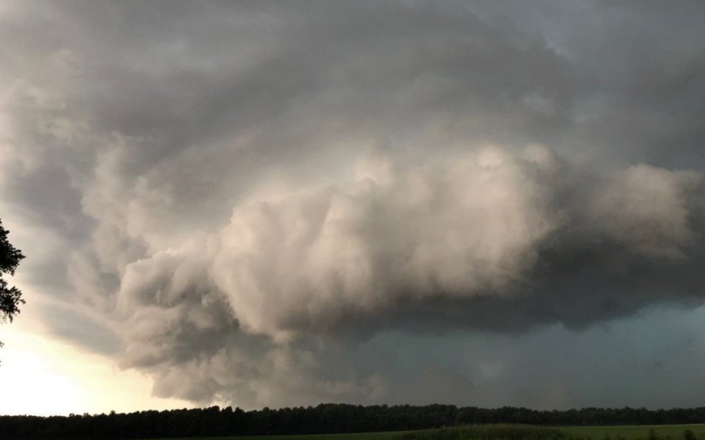
Here is another shot of the same storm a few miles southwest as I was driving.
- 2,802 replies
-
- 6
-
-
- severe
- thunderstorms
- (and 4 more)
-
Damn. At least it wasn't a flood.
-
Total rainfall for the storm here was 0.85". It was going sideways though, so probably more than that fell.
-
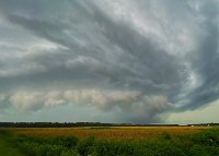
Shot of the storm approaching here from the end of my driveway. The rush of wind was impressive on the front end, and the power went out pretty quick. Just came back on after about an hour. Lots of tree debris and branches down but no major damage. Nice storm.
- 2,802 replies
-
- 15
-
-

-
- severe
- thunderstorms
- (and 4 more)
-
Yeah lots of booming thunder here. Picked up 0.65" of rain.

