
CAPE
-
Posts
36,402 -
Joined
-
Last visited
Content Type
Profiles
Blogs
Forums
American Weather
Media Demo
Store
Gallery
Everything posted by CAPE
-
This one is a banger. Sounds/feels like bombs dropping out there.
-
Hearing more thunder to the west. Lets see what round 2 can do.
-
lol be careful!
-
Yeah it is a different animal. You could hate a typical IPA and love the 120 lol.
-
Looks like a wrap for here. Lots of rumbles and a couple of booms, and 0.30" of rain. After last night's big storm, this is perfectly fine with me. 1.75" since last evening, and no wind impacts.
-
Sounds exactly like what I had last night. Way more fun than today.
-
Barely on the edge of this one. Some impressive lightning and booms of thunder though. Looks like Easton may get it pretty good.
-
Blocking would be lovely, but as we all know, its pretty rare during winter lately. We could see something transient ofc, but if this winter is to feature a colder period, I am inclined to think it will probably require a favorable EPAC for a time, something like Jan of 2018. No one in DC area should expect more than a low end warning event or 2 at best, and hopefully a few 1-2" deals. That would be a major win after the debacle of last winter.
-
QBO won't make much difference. Its impacts are nebulous imo, and even more so in Nina. The AO/NAO is pretty much guaranteed to be positive for the winter months based on persistence and general correlation to Nina. Not to say we wont have a few periods where it is less positive or neutral. Maybe the solar minimum will save the day(winter).
-
The thinking is more linear as it moves eastward towards the coast, and reading the discussion from Mount Holly they think the most likely place for a tornado is in Cecil over into Newcastle in DE up into SE PA. Possibly some interaction with the warm front lying across that area, backing the flow some is my guess. Bigger overall threat will be damaging straight line winds, with fairly strong winds aloft and decent Dcape. Bowing segments generally produce straight line winds but can also produce tornadoes as vorticity sometimes develops on the north/south end of the line. How far north are you?
-
Yeah a CanSIPS Dec followed by a CFS Jan and Feb would be pretty decent. A month from now we can reanalyze.This is fun.
-
Yup. At some point I am just gonna say eff it and let grow what wants to grow. A combo of clover, dandelions, moss, and crabgrass seems like a nice variety of green ground cover. And some pretty little flowers too!
-
Latest discussion from SPC-
-
I hope the heavy rain manages to avoid my yard today. Got plenty last night, and some of the grass I planted a few weeks ago looks a bit meh. With the lowering sun angle there isn't as much sun through the trees to really dry things out.
-
The latest CFS runs now have a torch for December lol, but then a pretty good look for January- similar to above but better- deeper trough and hints of a bit of HL help. Looks pretty similar to h5 back in Jan of 2018 when we had the cold period(and the bomb cyclone). February doesn't look terrible either. All just for fun ofc at this juncture with these climate models.
-
6z 3km NAM suggestive of super cells transitioning to QLCS. Has what appears to be a bowing segment with a cyclonic head developing and moving towards the lower eastern shore.
-
If @JakkelWx gets a super cell over his yard I'll go chase it though.
-
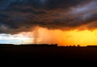
Looks like its over here, No wind, which is fine with me. Impressive deluge and back end electrical storm with the following cell. 1.45" Y'all can have tomorrow.
-
Well the second part has been impressive with frequent thunder and lightning. Looks like the rain should slack up soon per radar. 1.42"
-
Incredible thunder and lighting with this second part. Just unplugged all my high end audio gear.
-
Denton is gonna get clocked.
-
Getting in on the edge of that severe area here now. Booming house rattling thunder.
-
Yes! But the thunder is ominous now. Over an inch of rain so far. Boom! Damn that was close.
-
The sw edge of this line moving through Wye Mills looks potent. I think that will slide south of me, Booming thunder now. 0.92" so far
-
Nothing severe here but absolutely pouring with some T & L.


