

CAPE
-
Posts
36,846 -
Joined
-
Last visited
Content Type
Profiles
Blogs
Forums
American Weather
Media Demo
Store
Gallery
Everything posted by CAPE
-
0.55" so far
-
Looking at radar, it seems to be shifting in this direction. I don't need 2"+ though. Last 2 events combined for 2.5+.
-
One will put you in a good place. That high 'food value' hits different. Drink 2 and sleep well.
-
Fucking hell this is good. Might be the best, most balanced version yet. This one is dry hopped, which gives a fantastic finish to the famous 120 malty-sweet backbone in the middle. Might stock up on this shit and let it age. @stormtracker
-
That persistent enhanced area of rainfall along and west of the bay esp east and south of DC is impressive. Some guidance had that depicted a couple days ago.
-
0.45" here so far. Been mostly light to moderate. Don't really need any heavy rain after the previous 2 events. This area is back to just abnormally dry now, from moderate drought previously. Hopefully the severe drought areas just to the west get dumped on.
-
Just picked up a 4 pack of DFH 120 min IPA that isn't the Utopias version. That's all most places have if they have it at all, and it just alters the flavor too much with the sherry notes. Had enough of that shit at 40 bucks. This is a limited release and the first time I know of it has the ABV prominently displayed on the carton. It varies between 15-20% from batch to batch over the years. Looking forward to popping one open shortly. Grab it while you can!
-
28
-
Glad I put the larvicide down yesterday when my wetland area was largely dry. After today's rain, many places now with a couple inches of water lying. If that comes to fruition, it will become pretty expansive.
-
This. Its early this year with the well above avg temps over the last couple weeks. Just look around.. shit be growing.
-
Because out there it's probably for tonight, thus the warning. Not sure about the growing season comment- that doesnt make sense. Freeze watches up for the MD eastern shore, down into VA and NC for tomorrow night. I bet Sterling will put one in effect overnight or AM tomorrow.
-
I'm not home but based on the Mesonet stations in Ridgley and Goldsboro looks like something in the neighborhood of 1.5".
-
0.14" Still a chance to salvage some decent rain I-95 S&E and esp towards the coast today. The forecast 1-1.5" for my yard likely isnt happening.
-
Houston damn. Great game!
-
High of 70. Now down to 55. The backdoor front/easterly flow changes things quickly this time of year.
-
The seasonal woodland wetland on the back of my property. Usually a foot of water over probably an acre from late Feb into May before the water table drops and it dries up. It's soft in places so a drenching rain sometime in the next week would probably get it going a bit. I only saw one small spot with water lying and sprinkled some larvicide in. Then I decided to lightly "dry seed" the whole area in anticipation of the possibility of significant rains over the next 10 days. A lot easier walking around now when its not a swamp lol.
-
lol true Can you effing believe Harbaugh got a 3 year extension???? UGH
-
It's probably time for Elias to go. He generally refuses to spend to add proven talent to the core young talent even though ownership gave him the go ahead. He gets a lot of credit for changing the fortunes of the franchise through scouting and player development etc, but he seems literally stuck in that mode.
-
Same as it ever was.
-
Not here, but I don't want it. Hope its correct. I wanna keep my seasonal wetland dry. That would be quite the feat this time of year. Maybe I can save 100 bucks on larvicide.
-
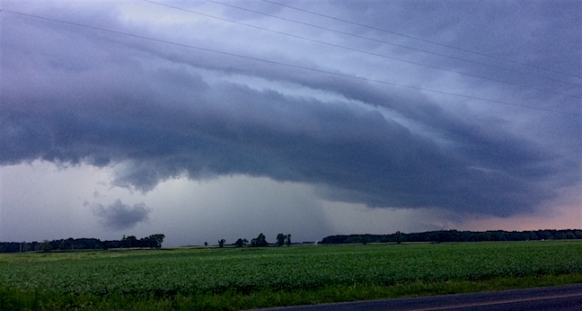
I grabbed it from my attachments. Uploaded on 8-3-17, so probably that day or maybe a day earlier. I have quite a collection of shelfs I have captured in this area over the years. That one was taken standing at the end of my driveway. Unfortunately it had to be cropped for a profile pic. Here is the full photo-
-
Upper 50s again tomorrow, and then a day later effing 80. So effortless to do this in late March/early April. Can't wait for 90s in May!
-
76


