All Activity
- Past hour
-
 wow Newark has even more than Philly....I've seen a tendency towards this in recent years, if we look back at historical summers like 1991 and 1993, EWR usually had around 10 more 90 degree days than NYC did and PHL usually had 5 more 90 degree days than EWR did back then.
 -
be careful of rip currents, 4 people have died this week already
-
1993: The Great Mississippi River Flood continued as flood waters flowing past Tarbert Landing, , MS reached 832,000 cubic feet per second, which is nearly 4 times the normal August flow. (Ref. AccWeather Weather History) wild how consistently hot it was here in 1993 and how the Midwest was consistently flooding 1955 - During the second week of August hurricanes Connie and Diane produced as much as 19 inches of rain in the northeastern U.S. forcing rivers from Virginia to Massachusetts into a high flood. Westfield MA was deluged with 18.15 inches of rain in 24 hours, and at Woonsocket RI the Blackstone River swelled from seventy feet in width to a mile and a half. Connecticut and the Delaware Valley were hardest hit. Total damage in New England was 800 million dollars, and flooding claimed 187 lives. (David Ludlum) 1955: The greatest DAILY precipitation to occur in the month of August or any month in Richmond, Virginia was 8.79 inches from Hurricane Connie. (Ref. Richmond International Airport Records) 1955 had that incredible record breaking heat in July and then in August the hurricanes came. 1936 - The temperature at Seymour, TX, hit 120 degrees to establish a state record. (The Weather Channel) 1936: The temperature at Seymour, TX hit 120° to establish a state record. Altus tied the Oklahoma state temperature record by reaching 120°. The high of 109° tied the record high for the month of August at Dodge City, KS. From the 12th through the 24th, there was a record 13 days on which temperatures reached 100° or more at St. Louis, MO. (Ref. The Weather Channel) (Ref. WxDoctor) incredible endless heat in 1936 continued
-
I think it could be like last fall, but don't see any fall record heat, as it's going to hard to beat 1983 when it comes to September heat.
-
-
Erin has a good circulation, but zero convection near the core. https://www.tropicaltidbits.com/sat/satlooper.php?region=05L&product=ir
-
would that make it hotter or would a recurving hurricane make it hotter here?
-
This is normal as the hottest departures always seem to be to the north. The Arctic has been heating up faster than any other region on the planet. I'm sure eventually, as the years ago by, those departures will reach us. It's like a fire spreading from the roof through the attic and then downwards.
-
In my experience, all these urban locations are much hotter than the suburban places I'm used to. I can tell you about my experiences driving from here to the Poconos, there are two main heat spikes, one is in Queens and the other one is in Eastern NJ. I find both of these places intolerable to walk around outside in more than a few minutes so I didn't unless I was out of gas lol. Once I drove past eastern NJ on I-80 and got past about Morristown, the weather always got much nicer. It's like this every summer, no matter how hot it is, those places are always hot. I can understand why some people have to work in these places, but why would anyone ever want to live there?
-
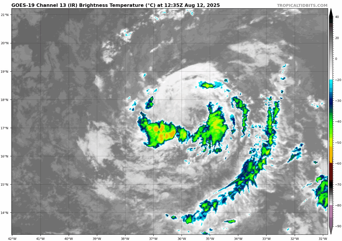
As you posted, the 11AM position dropped from 5AM’s 17.4N to 17.2N. Also, the new track dips down to 16.5N tomorrow vs the prior advisory’s 17.0N: FORECAST POSITIONS AND MAX WINDS INIT 12/1500Z 17.2N 36.3W 40 KT 45 MPH 12H 13/0000Z 16.8N 39.1W 40 KT 45 MPH 24H 13/1200Z 16.5N 42.3W 40 KT 45 MPH
-
Can they give you an estimate on what you will gain or is it a gamble?
-
Sell all . Euro sucks in convection . Trust us
-
is this even a tropical storm right now

-
hispaniola shred?
-
Great Post!!! This is exactly what I was talking about earlier this morning. Erin is going to be ingesting in significant dry air looking at the push NE to SW from Sarhan Africa especially with that well defined broad circulation. I do predict moderate level of keeping in check and its likely to weaken as it moves west bound and possibly redirected west-southwest for a time due to the nature of the flow. That is an absolute brick wall of dry air. Erin's forward speed towards that brick wall is going to play a significant role as to what's going to happen from this very point clear on into the next 3-5 days because it is moving in tandem with this dry air layer from Africa moving west and southwest from Sarhan Africa.
-
Continuing to move south of forecast
-
 Yeah, some of the AIFS members are closer to the Southeast than the EPS. This would be a big modeling coup for AI if it comes to pass. Could affect the whole pattern going forward. A slower development would allow a more southerly track.
 -
 it needs to develop into something first
-
If there were a record for the number of cloudy days during the summer with no rain we would break it easily this year...
-
 Not from that latitude way out east. This recurving near or just west of Bermuda
 -
 Onshore barrage / heavy rain there. We had more like a California first week here dry / onshore.
 -
Still a few around here. But far less Lots of acorns dropping though. Weird
-
 Very upside down month, based on the average highs for the first 11 days of August. Charlotte is nearly 7F colder than Burlington, Vermont, and 6F colder than Buffalo.
 -
For our friends in the Antilles, this is increasingly becoming a little close for comfort. Could be some indirect impacts there that become more direct if the south shift continues. To @40/70 Benchmark’s point earlier, that can muck things up if the ridge also ends up trending stronger or the big ULL in Canada is weaker in the long range. Still a lot to sort out here.