All Activity
- Past hour
-

Pittsburgh PA Fall 2025 Thread
TimB replied to TheClimateChanger's topic in Upstate New York/Pennsylvania
Today will be the 16th below normal day in a row at PIT. By the time this streak ends, it should be the longest streak of below normal since 21 days at this same time of year in 2017. -
Err...you kinda confirmed my point about Lamar's availability on that play by sharing this. Lamar literally said he would've gone for it if jot for the cramp--and Lamar does not lie about stuff. Think of his history and how much of a competitor he is--if he could go you KNOW he woulda been right out there calling for them to go for it. And ya want more evidence? Lamar was absolutely LEVELED by a D-lineman the play before. That is probably what caused it. So your "Lamar is covering for his coach" is pure speculation that doesn't match with his history or character. Now i know you gonna think I'm defending Harbaugh overall but I'm not--so don't misunderstand...I am NOT disagreeing that Harbaugh has issues with game management. But I DO disagree with you saying Lamar could've played. And I also do not believe a 30 second timeout would've been enough to get Lamar back out there. Now...could they have brought in Cooper Rush and just ran Henry right at 'em? I can understand that argument.
-
IMO a ton of cooling has to happen in the northwest PAC over an extended period of time this fall. The cooling pattern has to be sustained over a long time. Let’s see what happens. SSTs that far above normal do feedback into the pattern and alter the global heat budget. If we were talking about anomalies of +2 or +3, then yes, I’d agree that it’s not feeding back, but this incredibly warm? I think the latent and sensible heat release absolutely does alter the global long wave pattern and is a very important factor like @donsutherland1 pointed out
-
must be the method the 3km uses to calculate CAPE but it sometimes seems to be on the higher side versus reality with MUCape.
-
Euro op ran from David’s basement

-

September 2025 OBS-Discussion centered NYC subforum
TheClimateChanger replied to wdrag's topic in New York City Metro
Yeah, but I follow A LOT of places. For the past decades/years, coop sites would routinely own all of the coldest statewide low temperatures. A lot of people referred to it as an "airport heat effect" but I'm seeing lots of airport sites now in the mix for coldest regional/state lows. They are doing WAY better when it comes to radiating heat away with these new sensors. I can see it with my own two eyes. I'm in the middle of the woods and the airport surrounded by concrete is routinely now seeing low temperatures as low as mine when it used to be several degrees hotter. That's not due to drought. -
certainly could see some showers/storms Saturday with that feature, though perhaps favored over the higher terrain? Sunday perhaps better suited for northern Maine.
-
Mm ...don't take that sneaky diving mid/u/a cold pool on Sunday for minimal, necessarily. that looks likes like a gusty outflow hailer producer. We have a west wind at the surface with NW at 700 mb, so we're taking our positive shear and rotating it around the dial, while the heights are rapidly falling at mid levels along with lower glaciation height through mid day with that diving aspect. It's prevalent on the overnight operational runs and is still D5/6 so the notion could vanquish... but that feature's been there in some for or another fairly consistently. so we'll see. 06z gfs lost it but had in the 00z, ranging to the aggressive cmc... Euro's sort of in between.
-

2025-2026 ENSO
40/70 Benchmark replied to 40/70 Benchmark's topic in Weather Forecasting and Discussion
@snowman19You seem to pointing out why 2013 isn't a replica analog rather than why we can't see similar sensible weather adjusted for CC....as far as the former, I agree...no season really is; but I think the latter is entirely feasible. -

Saturday 9/6 Strong/Severe storm potential
HoarfrostHubb replied to Torch Tiger's topic in New England
And they added a 5th. Two in Paxton NOUS41 KBOX 091347 PNSBOX CTZ002>004-MAZ002>024-026-RIZ001>008-100200- Public Information Statement National Weather Service Boston/Norton MA 947 AM EDT Tue Sep 9 2025 ...NWS Damage Survey for 09/06/2025 Tornado Event Update #1... NWS Boston meteorologists conducted a storm survey in central MA regarding the storm damage that occurred on Saturday, September 6th, 2025. The survey team found evidence of brief EF-1 tornadoes in Paxton, Holden, Berlin, and Stow MA. There were 5 separate tornado touchdowns across these areas which are listed in greater detail below. Damage was primarily uprooted trees...soft and hardwood trees with sheared trunks. Some trees fell on or near houses and vehicles, but fortunately, there were no injuries or fatalities reported. Many eyewitnesses got the alerts on their cell phones and heeded the warnings issued. They also recalled the freight train noises and felt the pressure changes in their safe spots when the tornadoes passed through. Special thanks to MEMA and these towns' respective police and fire departments for their assistance and resources used for this survey. .Paxton/Richards Ave... Rating: EF1 Estimated Peak Wind: 100 mph Path Length /statute/: 0.17 miles Path Width /maximum/: 50 yards Fatalities: 0 Injuries: 0 Start Date: 09/06/2025 Start Time: 04:02 PM EDT Start Location: Paxton / Worcester County / MA Start Lat/Lon: 42.317 / -71.9292 End Date: 09/06/2025 End Time: 04:03 PM EDT End Location: Paxton / Worcester County / MA End Lat/Lon: 42.3177 / -71.9261 Survey Summary: Tornado briefly touched down near Arrowhead drive in Paxton, crossing Richards Ave and likely lifting after causing significant tree damage in its path. Several softwood trees snapped at the trunk or uprooted. Survey was partially conducted with drone footage provided by Holden Fire Department, special thanks to them for their assistance. Also special thanks to Paxton Fire Department for bringing the survey team to the damage site. .Paxton/ South Road... Rating: EF1 Estimated Peak Wind: 94 mph Path Length /statute/: 0.13 miles Path Width /maximum/: 100 yards Fatalities: 0 Injuries: 0 Start Date: 09/06/2025 Start Time: 04:06 PM EDT Start Location: 2 ENE Paxton / Worcester County / MA Start Lat/Lon: 42.3216 / -71.8904 End Date: 09/06/2025 End Time: 04:07 PM EDT End Location: 2 ENE Paxton / Worcester County / MA End Lat/Lon: 42.3226 / -71.8883 Survey Summary: Tornado briefly touched down near a section of South Rd in Paxton. Damage was limited to several softwood trees being uprooted. .Holden Tornado... Rating: EF1 Estimated Peak Wind: 104 mph Path Length /statute/: 0.15 miles Path Width /maximum/: 100 yards Fatalities: 0 Injuries: 0 Start Date: 09/06/2025 Start Time: 04:08 PM EDT Start Location: 1 SSW Holden / Worcester County / MA Start Lat/Lon: 42.3332 / -71.8618 End Date: 09/06/2025 End Time: 04:09 PM EDT End Location: 1 S Holden / Worcester County / MA End Lat/Lon: 42.334 / -71.8591 Survey Summary: EF1 tornado briefly touched down over Willow Brook Rd in Holden causing significant tree damage. .Berlin Tornado... Rating: EF1 Estimated Peak Wind: 104 mph Path Length /statute/: 0.60 miles Path Width /maximum/: 150 yards Fatalities: 0 Injuries: 0 Start Date: 09/06/2025 Start Time: 04:25 PM EDT Start Location: 1 W Berlin / Worcester County / MA Start Lat/Lon: 42.3854 / -71.6642 End Date: 09/06/2025 End Time: 04:27 PM EDT End Location: 1 W Berlin / Worcester County / MA End Lat/Lon: 42.3878 / -71.653 Survey Summary: EF1 tornado touched down west of Barnes Hill road in Berlin, MA and traveled ENE crossing Derby road and West street. Many soft or hardwood trees snapped at the trunk or uprooted. Survey was conducted using drone footage supplied by Berlin, Police Department. Special thanks to their team for their assistance. .Stow Tornado... Rating: EF1 Estimated Peak Wind: 104 mph Path Length /statute/: 2.38 miles Path Width /maximum/: 100 yards Fatalities: 0 Injuries: 0 Start Date: 09/06/2025 Start Time: 04:30 PM EDT Start Location: 2 E Bolton / Middlesex County / MA Start Lat/Lon: 42.4298 / -71.551 End Date: 09/06/2025 End Time: 04:34 PM EDT End Location: 1 NW Stow / Middlesex County / MA End Lat/Lon: 42.4425 / -71.5077 Survey Summary: An EF1 tornado touched down in Stow, MA near Maple street and continued ENE over Bose Avenue causing significant tree damage. The tornado lifted somewhere near Harvest Drive and touched down again about 1.25 miles ENE just west of Packard road and continued across Carriage lane before lifting again. This tornado caused significant tree damage with several hard and softwood trees uprooted or snapped at the trunk. && EF Scale: The Enhanced Fujita Scale classifies tornadoes into the following categories: EF0.....65 to 85 mph EF1.....86 to 110 mph EF2.....111 to 135 mph EF3.....136 to 165 mph EF4.....166 to 200 mph EF5.....>200 mph NOTE: The information in this statement is preliminary and subject to change pending final review of the events and publication in NWS Storm Data. $$ -
2025-2026 ENSO
40/70 Benchmark replied to 40/70 Benchmark's topic in Weather Forecasting and Discussion
I think if you want a big winter, the WPO is going to have be less severely positive than it has been....like 2017, for instance...which I believe may be the case. -
yeah MUCAPE looked nonexistent so not sure what the 3k is on.
-
September 2025 General Discussion
TheClimateChanger replied to Geoboy645's topic in Lakes/Ohio Valley
Wow! 23F at Sidney, Ohio yesterday. Also, 32F at Springfield, Ohio. -
2025-2026 ENSO
40/70 Benchmark replied to 40/70 Benchmark's topic in Weather Forecasting and Discussion
First of all, I think the trend concerning the PDO is what is of most relevence with respect to sensible weather, not the absolute value. Secondly, the RONI is nearly dead-nuts on with 2013....and finally, I'm not sure the solar and statosphere differences are really that big of a deal. First of all, that was a very strongly +AO/NAO season, so that wasn't the main hemispheric driver, anyway. Additionally, I have written in great detail about how an easterly QBO near solar max isn't as hostile to episodes of high latitude blocking as some seem to think. We are probably going to see more arctic blocking than we did that year. Replica season? No....western Pacific is less favorable and CC has continued...but I see no reason why it can't be included in varuious seasonal composites, as it has been, and continues to be. -
So basically if we cant cool the western pac down say goodbye to snowy winters in the east?
-
Can't beat that! Enjoy! Now if only we could keep this rolling through December...
-
probably just showers as we don't really have any instability around.
-
A ton has to shift for 13-14 to be a good analog. Besides the anemic Atlantic tropical season, low arctic sea ice and the cold North Atlantic SSTA, I see very little matching up. No -IOD, as you pointed out the PDO is so far from a match it’s not funny, that was a Victoria mode (basically +PDO alignment) back in 2013, it was +QBO, solar/geomag was rising off of a solar minimum, no La Niña back then; cold-neutral, no -PMM. Since the PDO cooling over the last 2 weeks in the northwest PAC was brought up yesterday, yes it cooled, but it started cooling at over staggering +11F SST anomalies there and as has already been stated by @bluewave those record warm anomalies are very deep in the subsurface. Here is the latest OISST, look at how insanely warm the anomalies still are:
-
2025-2026 ENSO
40/70 Benchmark replied to 40/70 Benchmark's topic in Weather Forecasting and Discussion
I can see in a practical sense, conversationally in an effort to convery how you feel the season will evolve, since most weather circles are privy with how each analog season behaved in terms of sensible weather. But as far as issuing a seasonal forecast, I agree 100%...my methodology is to use a composite and attempt to convey the element from each analog season that will be similar to the current season. This is important because one season may be a fantastic analog in one sense, but there are bound to be ways in which it is not..this harkens to what you were saying about the challenge in finding a replica season. Good luck- -
A little late here, but I just added up what we got from that ferocious front (just crazy downpours/wind/thunder for about a half hour), plus rain that evening and next morning: Total is 1.27 inches, if my math is correct. That's pretty good, but it is forecast to be dry, sunny, nice actually, but for next seven days. So...in summary, it's still wicked dry around here. https://droughtmonitor.unl.edu/CurrentMap/StateDroughtMonitor.aspx?Northeast I knew it was drier a little to the North (old neighborhood--Braqttleboro), but anyway, too dry. Edit to add: Wow, way worse farther North. I hadn't seen the summary/graphic yet. Northeast Drought Summary On this week’s map, widespread degradations were made on the map including expansion of areas of drought in West Virginia, Pennsylvania, New Jersey, New York, Vermont, New Hampshire, and Maine. The most severe drought in the region is currently centered on areas of central Maine and northern portions of Vermont and New Hampshire. In these areas, numerous observing stations reported precipitation totals for the past three-month period that were in the top-5 driest on record including Barre, Vermont (-6.76-inch departure from normal; driest on record), Berlin, New Hampshire (-3.95 inches; driest on record), and Portland, Maine (-5.87 inches; 3rd driest on record), according to data from the Southeast Regional Climate Center (SERCC). Moreover, numerous streams and rivers across the region were reporting streamflows that are well below normal levels, according to the U.S. Geological Survey. For the week, much of the region was quite dry; however, some light rainfall accumulations (<2 inches) were observed across isolated areas New York, Connecticut, Massachusetts, New Hampshire, and Vermont. Average temperatures were below normal across most of the region, especially in the southern extent, where temperatures were 8 to 12 degrees F below normal.
-
3k NAM pretty juicy tomorrow morning, thunderstorms?
-
1.42" of rain from stms last night. Much needed. 2.03" for the month (avg 3.53") so a good start.
- Today
-

September 2025 OBS-Discussion centered NYC subforum
psv88 replied to wdrag's topic in New York City Metro
Yes, the wind stays up on the hill a bit. I radiate very quickly after dark but at some point before dawn the wind creeps up -
2025-2026 ENSO
40/70 Benchmark replied to 40/70 Benchmark's topic in Weather Forecasting and Discussion
Mirrors impact on winter storms. As a blogger, I like it....only care to write about big fish. -
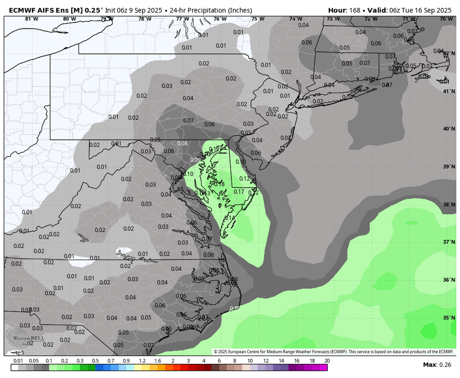
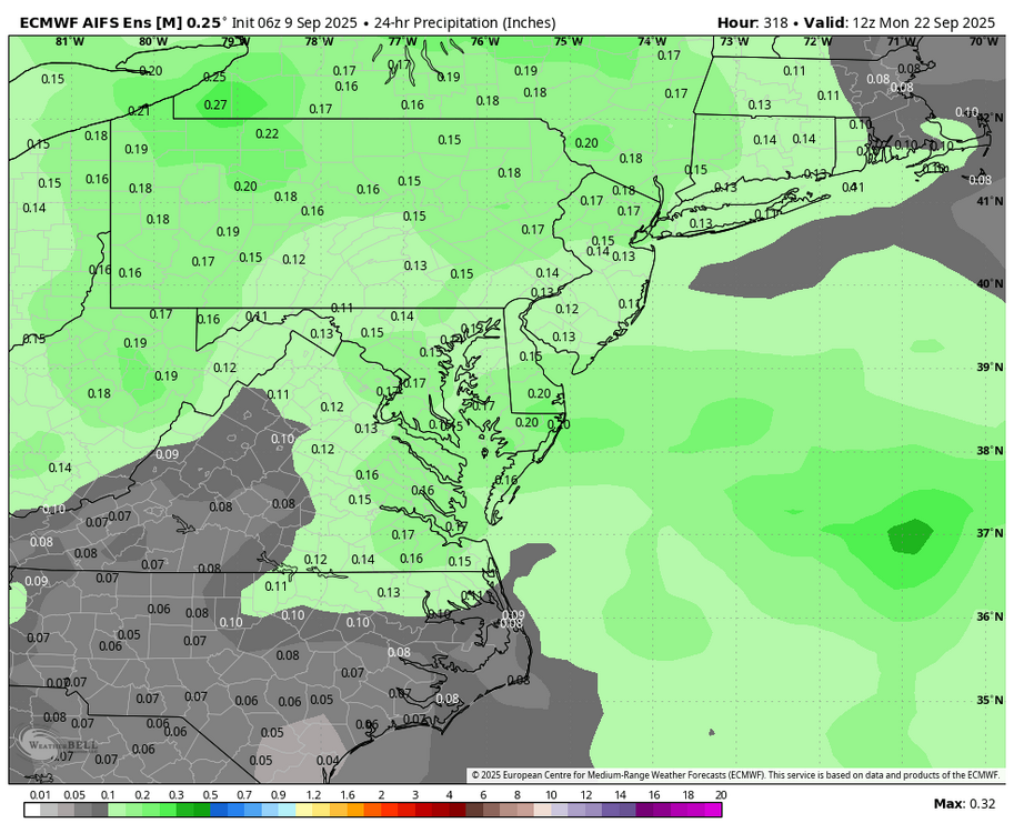
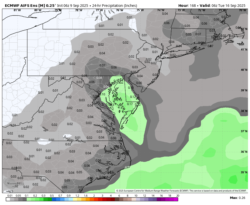
6Z EURO AI: maybe around the 16th or 22nd we see some rain.