All Activity
- Past hour
-

December 2025 Short/Medium Range Forecast Thread
John1122 replied to John1122's topic in Tennessee Valley
The 15z axis is slightly north but bullseyes the Nashville area. -
4 days out public would be pist they didn't know sooner
-
One of the reasons why it's so easy to be pessimistic is because of Jan-Feb 2025 and Dec 2022. Those patterns, observed from a far, would have been a gangbusters wintry weather period in the 2010s. But it just didn't materialize. In fact in December 2022, hardly any of us saw even 1 flake of snow. We've seen numerous good patterns (not just out in model fantasy land, but actually experiencing the good patterns) since winter 2019 that just failed to materialize winter weather events. Sure, those patterns produced cold, and sometimes, serious cold. But almost nothing came of those time periods. If that didn't happen, I think we would all feel more comfortable about this month.
-

December 2025 regional war/obs/disco thread
Cold Miser replied to Torch Tiger's topic in New England
When was the last, truly great, region wide KU? -
December 2025 Short/Medium Range Forecast Thread
John1122 replied to John1122's topic in Tennessee Valley
The 14z HRRR was very similar to the RAP. -
Give this and the 6z euro maybe we watch.
-
Finely chilly too aside from ern Plymouth county to cape but eventually some snow there too.
-

December 2025 regional war/obs/disco thread
weatherwiz replied to Torch Tiger's topic in New England
I don't think the GFS should be totally tossed. Its idea of amplifying that northern stream has validity. Whether there is some phasing is another story but I'd watch this -
I think its 5 in NYC
-
Snow squall warnings currently posted in parts of CNY and NPA. The squalls probably won't hold together as the front slides southward through our area, but there's a small chance.
-
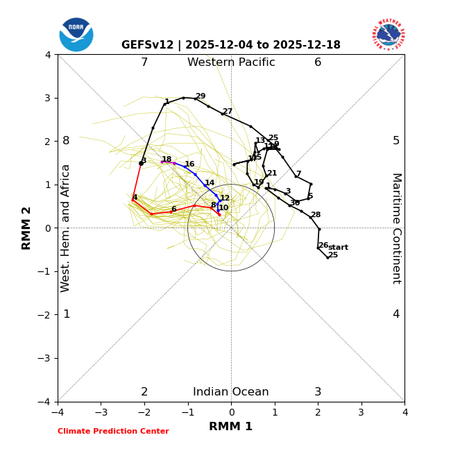
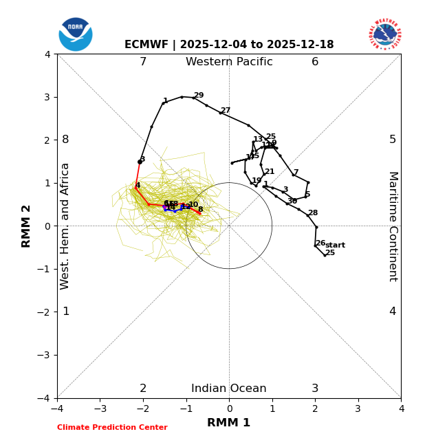
Just like yesterday, the GEFS and EPS disagree on how long the MJO will stay in phase 8: GEFS: only 6 days though it returns for rd 2 on 12/18: But the EPS, which recently has been much steadier and has been verifying better than GEFS since phase 7, once again is going with a very long phase 8 (16+ days, longest in 50 years):
-
Nice hit!
-
GFS not backing down
-
Yeah...Depends on what time we get out of there and how quickly Melina wants to get home. I know I have to stop at Bass Pro/ Cabellas on the way back through as well.
-
GFS is partially phasing the two streams which helps it amplify Sunday night.
-
yea this cold with no legit snow is worst case scenario.
-
Or use it very cautiously. After the 2.4" we had on Nov 16 the snow cover hung around for 7 more days, despite upper 30s maxima and sunny/PC skies. Move those conditions to March 16 and the cover is gone 2 days after the storm. Noting sun angle in December means holding onto the pack.
-

December 2025 regional war/obs/disco thread
TauntonBlizzard2013 replied to Torch Tiger's topic in New England
You’ve been on a heater over the last couple of years. only a 4 hour drive away but might as well be on the moon with the sensible weather differences -
I would make the 13th.
-
December 2025 Short/Medium Range Forecast Thread
Scottie16 replied to John1122's topic in Tennessee Valley
What I like to do is look on wunderground at the different weather stations throughout the valley. It usually is a good indicator on where the rain/snow line could setup during nowcasting. . -
December 2025 regional war/obs/disco thread
weatherwiz replied to Torch Tiger's topic in New England
GFS much sharper with that northern stream s/w sunday night -
Gfs trying for the 8th.
-
3-6” in like 1991 would have half the population storming the grocery stores. I remember back then how massive a 3-6/4-8” storm sounded. Im ok with nickels and dimes over the next week as long as we keep the longer wave pattern advertised. I think we’ll score something bigger at some point. We get a huge -WPO reload too so I don’t think the general cold pattern is going anywhere regardless of whether we relax a touch mid-month or not.
-

December 2025 regional war/obs/disco thread
ma blizzard replied to Torch Tiger's topic in New England
I hear ya man it's been a tough stretch. I'm used to being on the wrong side of the gradient in marginal events over here so I get it. -
I think Dec in the city averages 2 inches of snow in Dec and not much more out here something like 3 inches or so.


