All Activity
- Past hour
-
-

Nov 28-30th Post Turkey Day Wintry Potential
A-L-E-K replied to Chicago Storm's topic in Lakes/Ohio Valley
Looking two or three inches low imby but not terrible, congrats to the qc and ia crew, lots of our regulars should jackpot -

December 2025 regional war/obs/disco thread
Kitz Craver replied to Torch Tiger's topic in New England
-

December 2025 regional war/obs/disco thread
Damage In Tolland replied to Torch Tiger's topic in New England
So nothing here ? Just f’ing great -

Nov 28-30th Post Turkey Day Wintry Potential
jlauderdal replied to Chicago Storm's topic in Lakes/Ohio Valley
I'm in Tampa on a layover, ORD this afternoon and then hunker down. We need Saturday afternoon to deliver an inch an hour to get us 9+. If we can get 3 by noon .5/hr for 6 hours we will be in good shape. -
Do we know exactly what is causing the warmer WPAC ocean temps (as opposed to any other region like CPAC or EPAC)?
-
At least the posts from NYC police cruisers have stopped.
-
Let’s do it
-
Will may be right. SNE is Dec 2007 NYC.
-
Lol at H85 though
-

December 2025 regional war/obs/disco thread
SouthCoastMA replied to Torch Tiger's topic in New England
retreating highs and marginal antecedent airmass is a theme of the last several years. makes it an easy call along the coast at least -

Nov 28-30th Post Turkey Day Wintry Potential
cyclone77 replied to Chicago Storm's topic in Lakes/Ohio Valley
Starting to look like 10+ is looking pretty likely now for the QC. Models that seemed to be backing down to reality a few days ago miraculously reversed course. It's always nice to see CAMs and global models both agreeing on big dog totals on every model cycle. -
Early season and retreating high. A month from now would be different.
-
Small bit of good news - cold is overperforming. For the midwest storm, their forecasters shifted their maps a tick south.
-
Goofus AI looked better
-
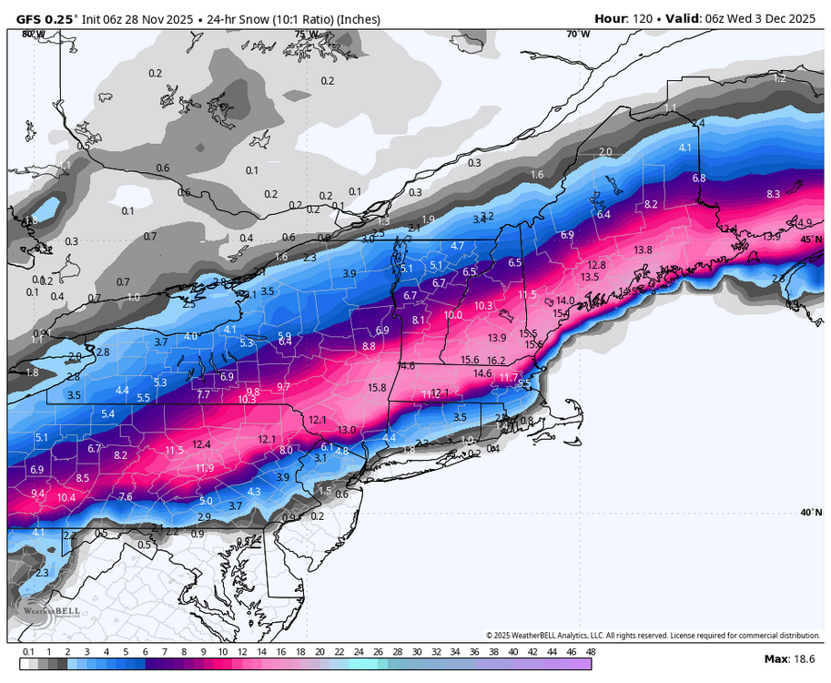
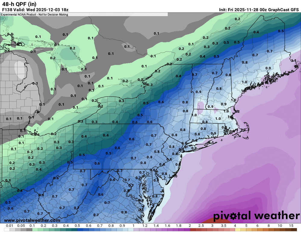
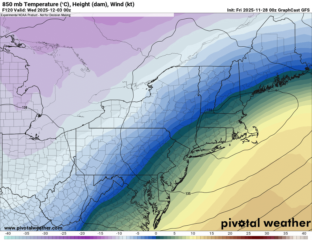
I think interior SNE will get some decent snow. Interior CT in that I-84 stretch might have some issues at 925 but we’ll see how hard that pushes inland. Lot of variation on guidance.
-
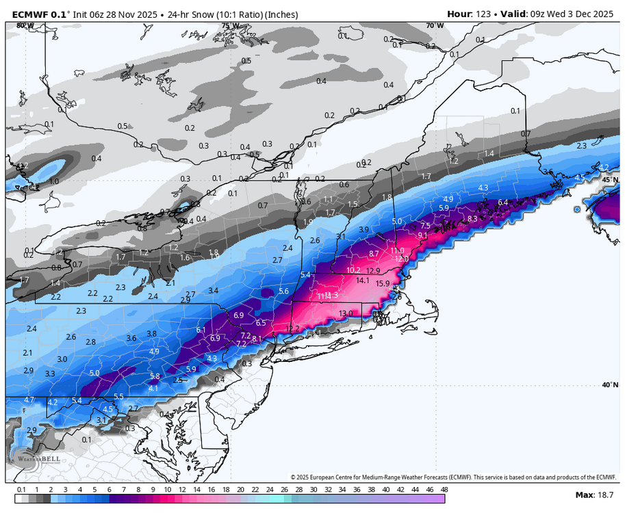
Looks like the mean ticked a bit west of 0z on the EPS.
-
Scoot is already down for the count and I have 0.1”
-
I can’t believe Euro AI is still almost a whiff. What a dumb model.
-
December 2025 regional war/obs/disco thread
Kitz Craver replied to Torch Tiger's topic in New England
Looking at that you’d think we’d all be slapping weenies, damn -

Nov 28-30th Post Turkey Day Wintry Potential
Baum replied to Chicago Storm's topic in Lakes/Ohio Valley
Here’s hoping you’re spot on. I’ll be at Wannemakers in DG first thing this AM getting the Christmas garland. Off the roads tomorrow. -

Central PA Fall Discussions and Obs
Blizzard of 93 replied to ChescoWx's topic in Upstate New York/Pennsylvania
0z Canadian looked decent as well for most of us.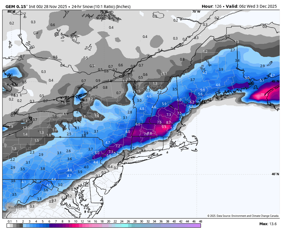
-
More like this. Need violence and anger.
-
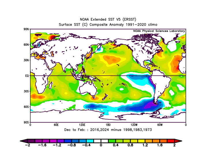
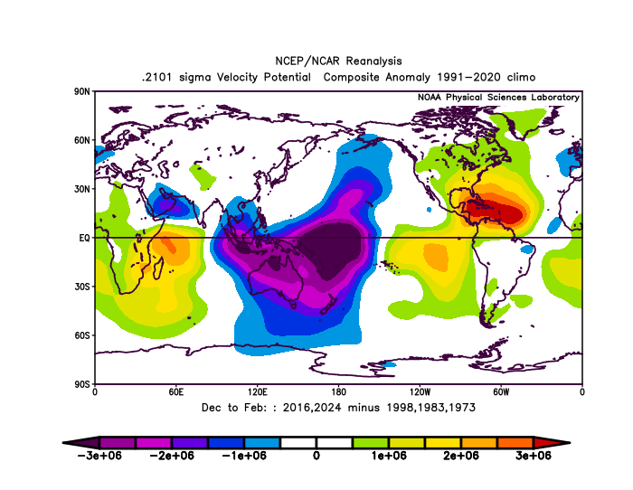
When we subtract the recent strongest El Niños from the era before the warming of the WPAC warm pool, it shows what I have been talking about. The WPAC hasn’t been cooling down like it used to during strong El Niños. So this leads to the forcing shifting further west than it previously did during El Niños. This is why we had Niña-like elements combining with the 2015-2016 and 2023-2024 events. During the weaker 2018-2019 and 2019-2020 events they couldn’t even couple and the La Niña background more completely dominated.
-
Central PA Fall Discussions and Obs
Blizzard of 93 replied to ChescoWx's topic in Upstate New York/Pennsylvania
6z Euro & 6z GFS are keeping CTP very much in the game.