All Activity
- Past hour
-
 .33 and had a nice 45 mph gust just now with fropa
 -
Man let’s Foc’ing go . We wild
-
Yes, just north of Whitman park up New York avenue.
-

E PA/NJ/DE Autumn 2025 Obs/Discussion
Birds~69 replied to PhiEaglesfan712's topic in Philadelphia Region
Not sure who pissed the wind off but 25mph+ wind gust happening out of nowhere, 50F -

Central PA Fall Discussions and Obs
Blizzard of 93 replied to ChescoWx's topic in Upstate New York/Pennsylvania
I’m ready for another year of tracking! Hopefully we are busy tracking storms & rumors of storms in between shoveling ground truth snow! -

November 2025 general discussions and probable topic derailings ...
Torch Tiger replied to Typhoon Tip's topic in New England
oke snow? -
Live near Crestwood. You lived near White Post and Whitman park?
-
 This line blowing through.
 -
November 2025 general discussions and probable topic derailings ...
Torch Tiger replied to Typhoon Tip's topic in New England
I saw lightning rn. -
November 2025 general discussions and probable topic derailings ...
Torch Tiger replied to Typhoon Tip's topic in New England
Too? -

November 2025 general discussions and probable topic derailings ...
CoastalWx replied to Typhoon Tip's topic in New England
Euro is damage Wednesday night too. -
November 2025 general discussions and probable topic derailings ...
Torch Tiger replied to Typhoon Tip's topic in New England
what event -
Central PA Fall Discussions and Obs
Blizzard of 93 replied to ChescoWx's topic in Upstate New York/Pennsylvania
I like the 20 to 30” snow total for Lancaster, which is very close to normal. We haven’t had above normal snow in the LSV since the 20-21 Winter, so I would sign up for this MU forecast. Near normal snow would feel like a blockbuster Winter compared to the last few years. -
This is a fun event
-
 I don’t think we had any here but I wasn’t looking closely. Had an instantaneous rain rate of 6.13”/hr.
 -
November 2025 general discussions and probable topic derailings ...
CoastalWx replied to Typhoon Tip's topic in New England
Beer -

November 2025 general discussions and probable topic derailings ...
powderfreak replied to Typhoon Tip's topic in New England
Your cold fronts after a cutter will be great? lol -

2025-2026 ENSO
donsutherland1 replied to 40/70 Benchmark's topic in Weather Forecasting and Discussion
In other words, things seem to be moving toward a vintage fast start to winter as is often, though not always, the case during La Niña winters. -
November 2025 general discussions and probable topic derailings ...
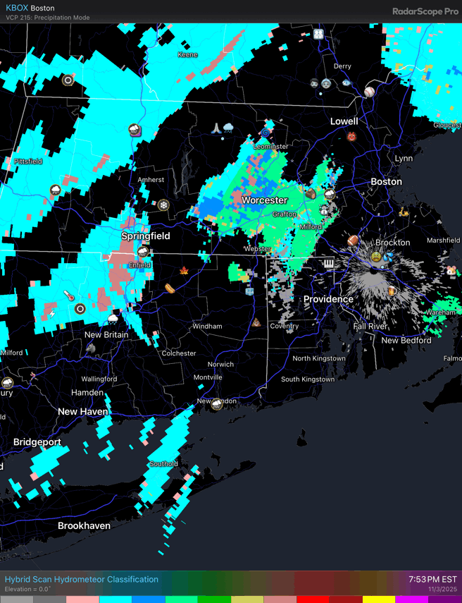
powderfreak replied to Typhoon Tip's topic in New England
Whats the scale on that product? Or is it as simple as the color coding is p-type? -
What does that have to do with winter? Lol
-
Yes, but sharp cold shots are still possible. Below normal months can also occur.
-
A few showers are possible tonight. Tomorrow and Wednesday will be mild days. Highs will reach the upper 50s and lower 60s. A weak cold front could cross the region Wednesday, perhaps touching off a few scattered showers. It will turn increasingly windy following the frontal passage. Highs will then fall back to the lower and middle 50s before milder conditions return for a time next weekend. Afterward, there is the potential for a short but sharp cold shot, possibly preceded by a chilly rain. The ENSO Region 1+2 anomaly was +0.1°C and the Region 3.4 anomaly was -0.6°C for the week centered around October 29. For the past six weeks, the ENSO Region 1+2 anomaly has averaged -0.05°C and the ENSO Region 3.4 anomaly has averaged -0.52°C. La Niña conditions will likely continue through mid-winter. The SOI was +18.96 today. The preliminary Arctic Oscillation (AO) was +1.583 today.
-

November 2025 general discussions and probable topic derailings ...
dendrite replied to Typhoon Tip's topic in New England
Low freezing levels and convection. Many are seeing some graupel make it to the sfc.
-

2025-2026 ENSO
Stormchaserchuck1 replied to 40/70 Benchmark's topic in Weather Forecasting and Discussion
There is a really strong timelag between Stratosphere warming and -NAO at different times of the year: Nov 1-15: +45 days Nov 15-30: +40 days Dec 1-15: +35 days Dec 15-30: +30 days Jan 1-15: +25 days Jan 15-30: +25 days Feb 1-28: +20 days March 1-31: +15 days Cold Stratosphere has a +0-day timelag to corresponding +NAO at all times of the cold season. -
November 2025 general discussions and probable topic derailings ...
CoastalWx replied to Typhoon Tip's topic in New England
Maxed out well SW of you. Settle down.