All Activity
- Past hour
-

2026-2027 Fall/Winter Mountain Thread
Met1985 replied to BlueRidgeFolklore's topic in Southeastern States
Yeah not great. Sent from my SM-G998U using Tapatalk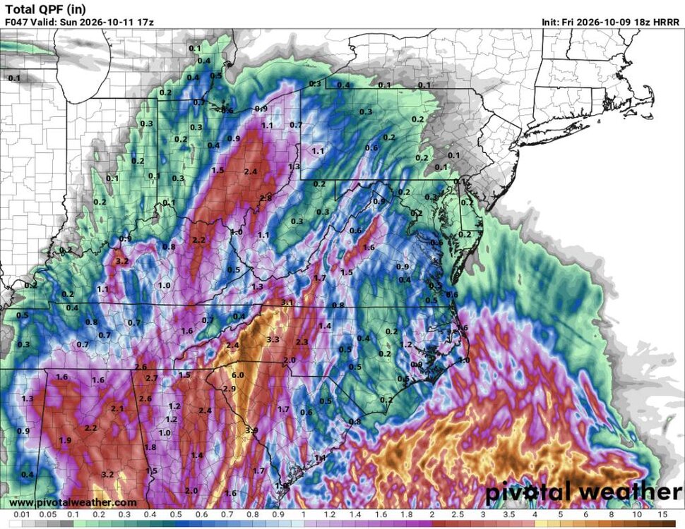
-
Got really lucky here in Gulf Shores that it went way east like the ICON and AI were showing. Hoping those east were able to prepare
-
Those poor people. I had to d 3 go arounds at Boston one time due to fog and that was awful. It was a smooth ride but those people are getting bounced around.
-
That would be awful to be on that flight.
-
Check out this nightmare. Delta flight from ATL to TLH trying to land (and not succeeding). https://www.flightaware.com/live/flight/DAL1984/history/20261009/2110Z/KATL/KTLH
-

2026-2027 Fall/Winter Mountain Thread
BooneWX replied to BlueRidgeFolklore's topic in Southeastern States
That’s putting it mildly too! Very anxious this evening. -
 https://queticarerx.shop/# overseas online pharmacy
 -
It would be interesting to know how much of that is premeditated cut outs to save the grid and make it easier to get back up and running.
-
Really looks like Destin is the spot unless there’s a wobble.
-
2026-2027 Fall/Winter Mountain Thread
Met1985 replied to BlueRidgeFolklore's topic in Southeastern States
Post it -
It looks like the trailing band of storms will stay off the coast for a while and may not even get to Tampa. No delays as of now. I think you are good.
-
140k customers without power in the region and climbing fast (was 100k 15 minutes ago)
-
About to board a flight from San Antonio to Tampa, hope they go far as hell south, want to stay far away from this cane .
-
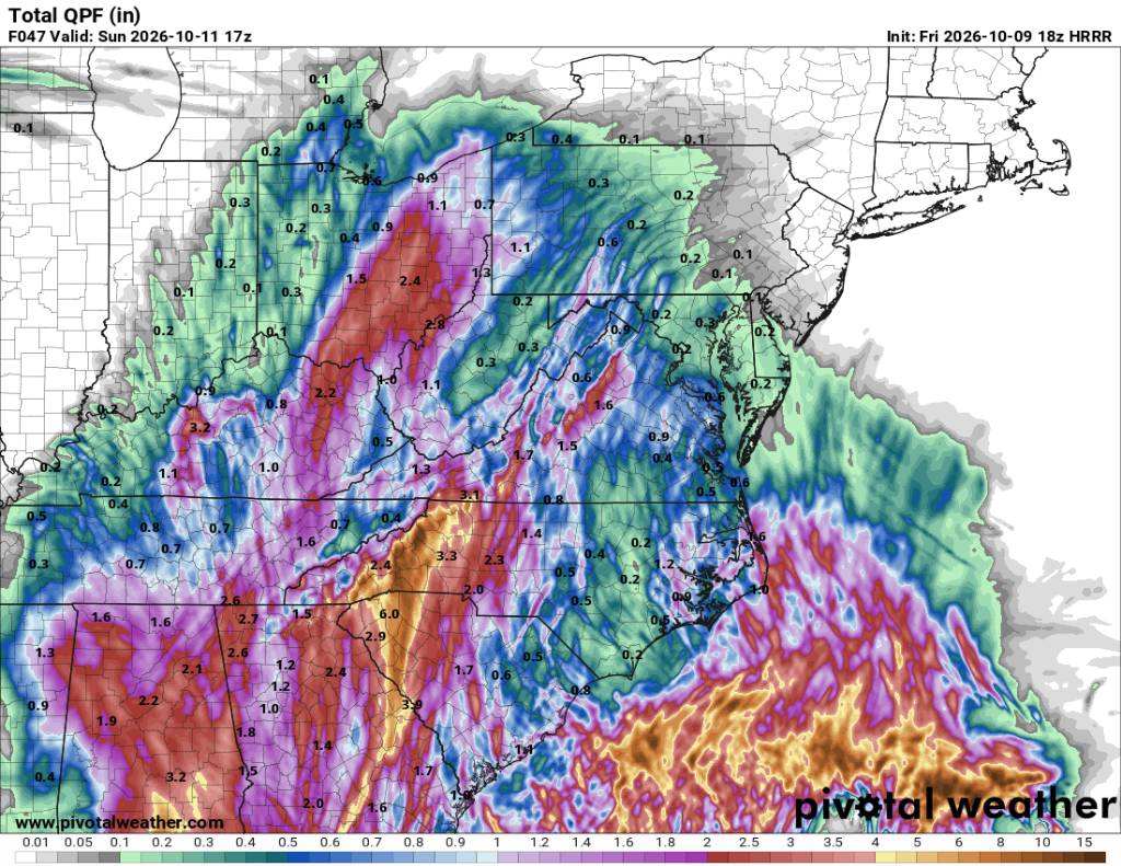
Got some watches in Virginia already Flood Watch National Weather Service Blacksburg VA 143 PM EDT Fri Oct 9 2026 NCZ001>003-018-019-VAZ015>017-032-101000- /O.NEW.KRNK.FA.A.0009.261010T1500Z-261012T0000Z/ /00000.0.ER.000000T0000Z.000000T0000Z.000000T0000Z.OO/ Ashe-Alleghany NC-Surry-Watauga-Wilkes-Grayson-Carroll-Floyd- Patrick- Including the cities of Whitetop, Dobson, Galax, Troutdale, Stuart, West Jefferson, Boone, Floyd, Wilkesboro, Sparta, Independence, and Volney 143 PM EDT Fri Oct 9 2026 ...FLOOD WATCH IN EFFECT FROM SATURDAY MORNING THROUGH SUNDAY EVENING... * WHAT...Flooding caused by excessive rainfall is possible. * WHERE...Portions of North Carolina, including the following areas, Alleghany NC, Ashe, Surry, Watauga and Wilkes and southwest Virginia, including the following areas, Carroll, Floyd, Grayson and Patrick. * WHEN...From Saturday morning through Sunday evening. * IMPACTS...Excessive runoff may result in flooding of rivers, creeks, streams, and other low-lying and flood-prone locations. Creeks and streams may rise out of their banks. Low-water crossings may be flooded. Storm drains and ditches may become clogged with debris. Extensive street flooding and flooding of creeks and rivers are possible. * ADDITIONAL DETAILS... - Upslope rainfall from a rather strong southeasterly Low level jet from the remnants of Isaias will bring increased precipitation along the crest of the southern Blue Ridge from Floyd county extending southwestward towards Watauga county. Widespread rainfall totals of 2-4 inches with locally higher totals in the 5-6 range will be possible, especially for areas like Meadows of Dan, Boone, and Blowing Rock. These higher totals may lead to isolated instances of landslides along slopes that have been modified by humans like embankments or cut slopes. These areas may also see increased rises on local streamflows that may lead to flooding across low-water crossings. - http://www.weather.gov/safety/flood PRECAUTIONARY/PREPAREDNESS ACTIONS... You should monitor later forecasts and be alert for possible Flood Warnings. Those living in areas prone to flooding should be prepared to take action should flooding develop. && $$ EB
-
He’s bored in his backyard
-
CPC has us in below average precip in the 3-4 Week.
-
60mph gusts starting to be reported along the coast.
-

2026-2027 Fall/Winter Mountain Thread
Tyler Penland replied to BlueRidgeFolklore's topic in Southeastern States
18z HRRR is concerning. Sent from my Pixel 10 Pro using Tapatalk -
Congrats on more rain! Dale City tallies shall challenge then surpass our meager amounts, 40.7 for the year. Enjoy this autumn, winter and well on into late spring in 2027. Mid Atlantic is right in the Plume! So is Destin, FL, as they are most assuredly finding out right about now. Some Southeastern communities will eclipse 20 inches easy, especially with training tropical thunderstorms.
-
ATL is favored by 3, but I'm not convinced they have a QB. Last year the Ravens only two wins vs >.500 teams were with Huntley as QB and Minter did do a good job in the preseason calling defensive plays, not ready to give up on that yet.
-
The big tor threat is often the day after landfall, when it becomes a baroclinic system w/ low-level tropical dew points and all you needs is just breaks in the clouds for a little CAPE, and look out! 44 tors in FL from Milton on 10/9/24 This is the largest calendar day tor outbreak on record In October and among the top 5 biggest tor outbreaks in Oct in the U.S. Milton also produced the costliest TC tor on record -- $514M from an EF3 that tracked in St Lucie and Indian River Counties.
-
Hard to find the eye now and most of the worst weather appears to be on the north side. Still going to be a dangerous storm
-
Yes, despite the erosion of the low level inner core, there’s still plenty of deep convection and lightning. This will still be a strong hurricane, as the NHC has said for a while now.
-
Doesn’t matter much now. Eyewall moving onshore
-
My guess is Cat 2 at landfall with numerous gusts over 100mph reported.