All Activity
- Past hour
-
Please post your July 2025 observations as well as other current or recent conditions at any location.
-

E PA/NJ/DE Summer 2025 Obs/Discussion
LVblizzard replied to Hurricane Agnes's topic in Philadelphia Region
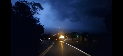
Constant lightning and a steady rumble to the SW. Been awhile since we’ve had a good nighttime show like this. -
Total June rainfall here was at a near normal 6.85”, with 6.8” of that falling June 1-18th. So, the last 12 days have been very dry. The first half of June had a wet 5.35”.
-

E PA/NJ/DE Summer 2025 Obs/Discussion
Joshb32689 replied to Hurricane Agnes's topic in Philadelphia Region
Coatesville area is going to be pushing Manheim totals soon with the way this radar is lining up. -

E PA/NJ/DE Summer 2025 Obs/Discussion
RedSky replied to Hurricane Agnes's topic in Philadelphia Region
Flash city outside with the radar lit up NAM and Hrrr clueless -
E PA/NJ/DE Summer 2025 Obs/Discussion
RedSky replied to Hurricane Agnes's topic in Philadelphia Region
4.80" with today's .40" -

2025-2026 ENSO
so_whats_happening replied to 40/70 Benchmark's topic in Weather Forecasting and Discussion
Just hope we can keep it going. -
Quite the lightning show looking out to my southeast.
-
Thankfully only .48 in Marysville today.
-
Lol, you & @canderson will likely need water delivered by @Voyager while the rest of us pump water out of our basements.
-

Central PA Summer 2025
Mount Joy Snowman replied to Voyager's topic in Upstate New York/Pennsylvania
That’s my fear, that tomorrow could offer a repeat. Although it seems like tomorrow’s storms should move through at a faster pace, hopefully. Weather roulette indeed. -
Decent light show with that storm near Asbury Park from here in Brick.
-
Looks like we get to do this tomorrow as well. Any idea the focus area for tomorrow or is it just a game of weather roulette. I didn't exactly have a super high rain chance for today this morning, only 40%, and this happened Sent from my SM-G970U1 using Tapatalk
-
You've been due for a day like this for how many times storms seemed to just miss you the past couple years. I had my crazy storm day last summer with those tropical remnants setting up a 10-15 mile training band that left with me close to 9". Sent from my SM-G970U1 using Tapatalk
-
Some places between Lancaster and Lebanon are almost at 7" from radar estimates Sent from my SM-G970U1 using Tapatalk
-
Central PA Summer 2025
Mount Joy Snowman replied to Voyager's topic in Upstate New York/Pennsylvania
Well forget sleeping. The whole house is up again. This is some of the most intense and persistent lightning I’ve ever witnessed. Phone keeps buzzing from NWS sending out warnings on an emergency flash flooding event in progress. Can’t get over how the radar just keeps firing in our direction. Very intense night around these parts. I’ll probably have damn near 6” come morning. Aye. -
I'm only at 0.70" for the day. 2 miles south they are all above 1.20". Couple miles north and no one's really above 0.45". So you and I are going to still be probably1.5"- 2" below normal for the year to start July while some of our board brethren will be 5"+ above normal. Heck, a couple of stations less than 5 mi from me have 6" more rain on the year than I do and are at +4" Sent from my SM-G970U1 using Tapatalk
-
The LCL have to be super low with how ridiculous low I see the clouds are during flashes of lightning Sent from my SM-G970U1 using Tapatalk
- Today
-
There is yet another line forming out by Gettysburg. This is nuts…
-
Happy July and Happy Birthday America!
-
 DCA _ NYC _ BOS ___ ORD _ ATL _ IAH ___ DEN _ PHX _ SEA 1.9 1.9 1.9 1.5 1.2 1.3 2.0 2.3 3.2
 -
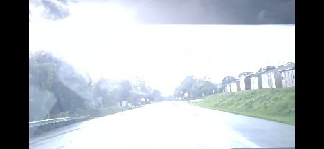
Finally got a tail end of the heavy rain
-
Fed a bunch of the goes satellite gifs and radar gifs from radarscope along with what sounding data i could get from the RAP for Harrisburg, Pittsburgh, Baltimore, Hagerstown and fed it into the custom gpt I've been slowly working on for weather that has plenty of good reference files to use. This is the response to The questions wise is happening and how long will it last The images together diagnose a boundary-anchored convective complex, with deep convection consistently regenerating over the area due to: A stationary mesoscale boundary anchored by terrain and earlier outflows. Sufficient instability and moisture, with storms rooted in the boundary layer. Weak mid- and upper-level winds, allowing for storm anchoring and repeated initiation. GLM confirms high lightning frequency, suggesting mature electrified updrafts. Satellite IR, RGB, and Sandwich images show severe convective indicators like cold U/V tops, ice plumes, and overshoots. [emoji352] Training Storm Duration Forecast – Camp Hill, PA (as of July 1, 2025) Prediction: The storm training over Camp Hill is likely to persist for at least another 90–120 minutes, potentially through midnight local time, with some weakening after that. Here's the expert-level breakdown: --- [emoji680] Why It's Still Ongoing 1. Persistent Boundary Anchoring the Convection Radar, GOES-16 visible (Band 2), and IR (Band 13) imagery show repeated cell development aligned with a quasi-stationary boundary. This boundary is being fed by moist inflow from the south, aided by local terrain (i.e., Blue Mountain convergence). Band 2 shows tight convective towers. Band 13 reveals a consistent overshooting top signal, meaning convection remains deep and strong. 2. GLM Flash Extent Density (FED) GLM data shows high-frequency lightning flash clusters (e.g., >100 flashes per minute locally). This high flash rate correlates with strong, vertically continuous updrafts and storm sustainability. 3. No Synoptic Forcing to Move It Along There's no significant mid- or upper-level jet support to shift the storms eastward. Upper-level winds are weak and the entire convective system is largely terrain-anchored. These are classic ridge-running backbuilders. --- [emoji326] Projected Evolution (Next 2–3 Hours) Time Window Likely Behavior Now–+30 min Persistent intense training over Camp Hill and adjacent downstream zones. New cells forming just upstream. +30–90 min Some signs of weakening begin as storm mergers and outflow contamination reduce instability. Flood threat peaks. +90–150 min Storms begin to decay or shift slightly southeast. Expect residual convection, but lighter and more scattered. --- [emoji3544] What Would End the Training? 1. Cold pool stabilization: If widespread downdrafts from merging cells finally chill the inflow. 2. Low-level exhaustion: Surface-based CAPE drops from rain-cooled air. 3. Nighttime boundary layer stabilization: More likely after 1–2 AM if inflow weakens. --- Sent from my SM-G970U1 using Tapatalk
-
2025-2026 ENSO
Stormchaserchuck1 replied to 40/70 Benchmark's topic in Weather Forecasting and Discussion
Really a great thunderstorm day! There were big lightning bolts for a long time close by, and I lost power for 3 hours. I was going to comment how earlier this morning it felt like Florida outside.. This thunderstorm season has been one of the better ones in several years. Everything turned green here in March and April.. I don't see any sign of drought. I realize we were below average for like 10 months in a row, but that has broken fast this Spring, in my opinion. Follows the trend that we have seen since 2002: Every time a developing drought occurs, we follow it with much above average precip in the eastern 1/2 of the US. -


.thumb.jpg.6a4895b2a43f87359e4e7d04a6fa0d14.jpg)