All Activity
- Past hour
-
Atleast Elias can't use Rodriguez as an excuse now to not sign a front line starting pitcher. I could just imagine Elias saying "we didn't sign anyone because when Grayson is back we'll have a 3 headed monster at the top of the rotation with Rogers and Braddish" Ni excuses now for Elias
-

November 2025 general discussions and probable topic derailings ...
weatherwiz replied to Typhoon Tip's topic in New England
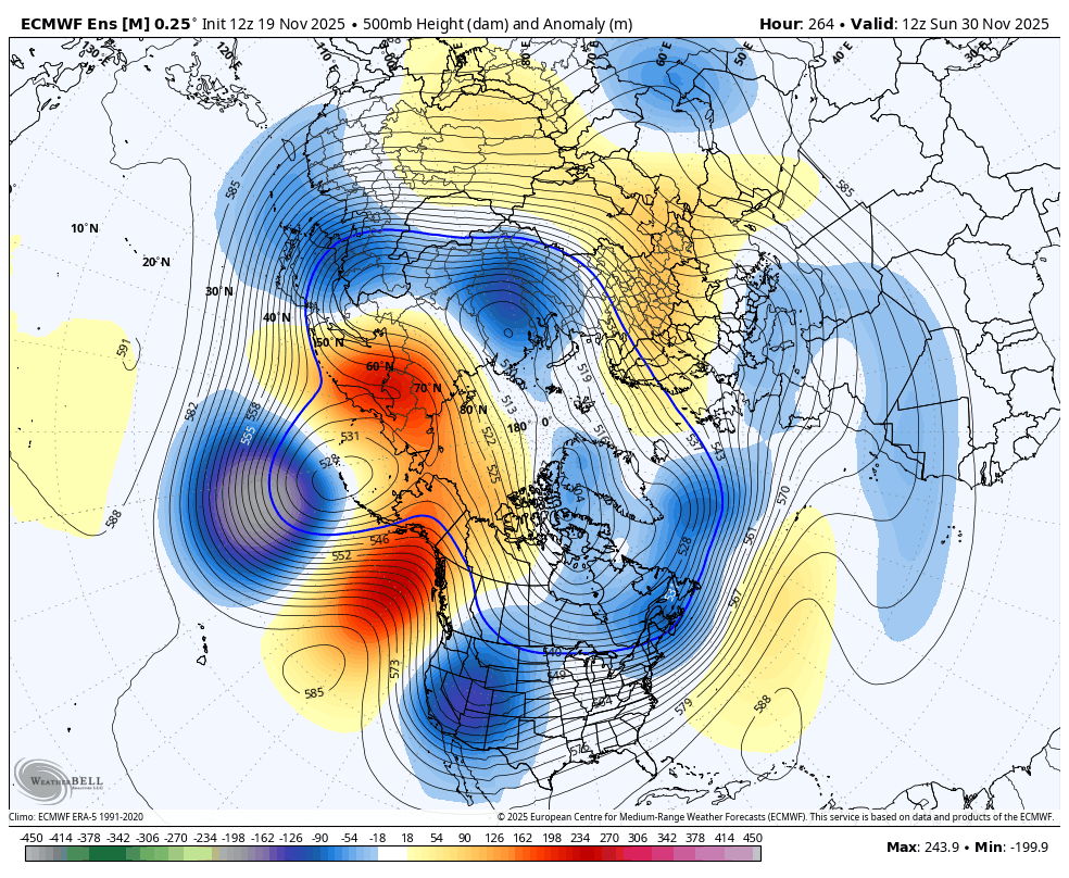
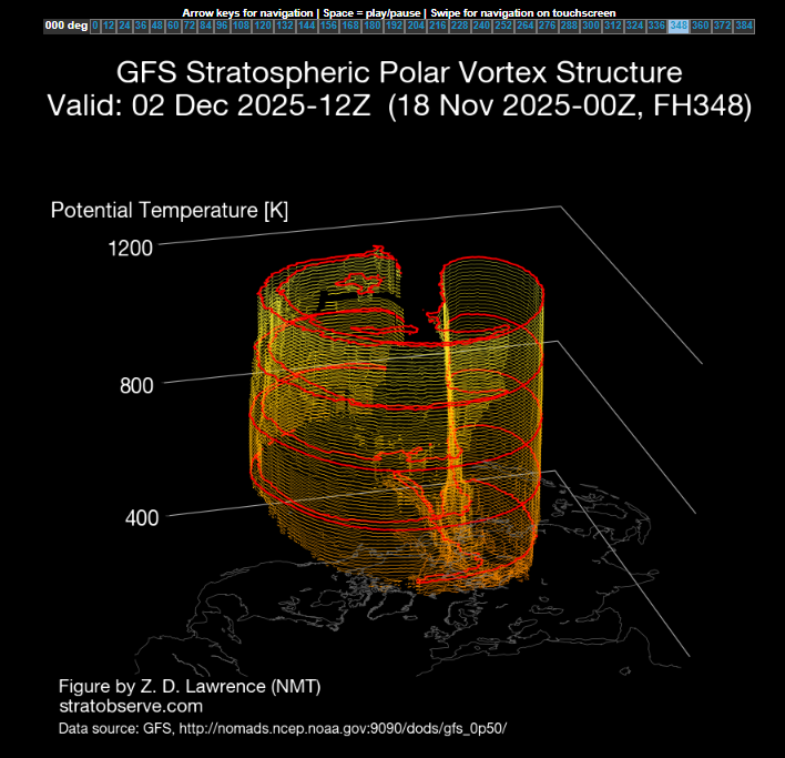
I thought there was a weak signal up around 10 hpa which strengthened down around 30 hpa and especially 50 hpa? But I may have diagnosed incorrectly -
What else will I do at 7am on a Saturday?
-

November 2025 general discussions and probable topic derailings ...
Typhoon Tip replied to Typhoon Tip's topic in New England
I don't like the fact that it isn't (first) emergent in the 10 hpa ... This appear to be up-welling from a very strong constructive interference at mid and upper level troposphere between Asia and the N. Pacific. I'm not sure it matters? ha. I mean, whether it's a SSW --> down-welling in the canonical sense and total behavior, or... some sort of fantastic ridge resonance that's bulging the disk from the bottom, the end result may end up with the same consequence... You get blocking and jet distributions S of normal PV latitudes ...and that in this case (sometimes it affects/offloads in Europe/Eurasia preferentially) modeled to favor our side of the hemisphere for a cold mass delivery/jet. It's an interesting question... but if you look at the GFS's 10hpa, no clue there's a warming event. All SSWs in the monitoring history going back to the late 1970s start between 1 and 10hpa, and then down well. This appears to be a "bulging" event. Similar to what Kevin lacks on his anniversary nights... -
I realize you are propagating out past this, but looking at the raw data presented here, I'll be damned if the Southwest US oriented trof doesn't seem like a recurring background state past several years.
-
ready 2 b buried
-
Nothing wrong with that. That would be ideal with the daily average highs being lower by mid-month. NYC's average high on Dec 1 is still 49 I believe.
-
November 2025 general discussions and probable topic derailings ...
weatherwiz replied to Typhoon Tip's topic in New England
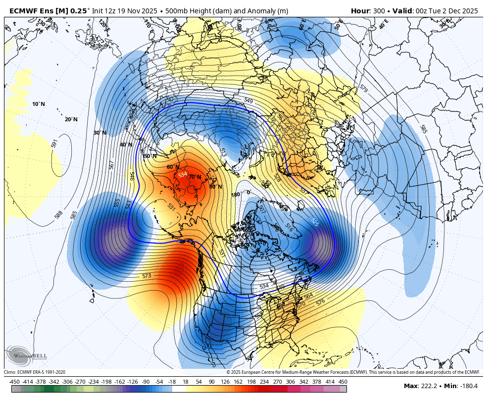
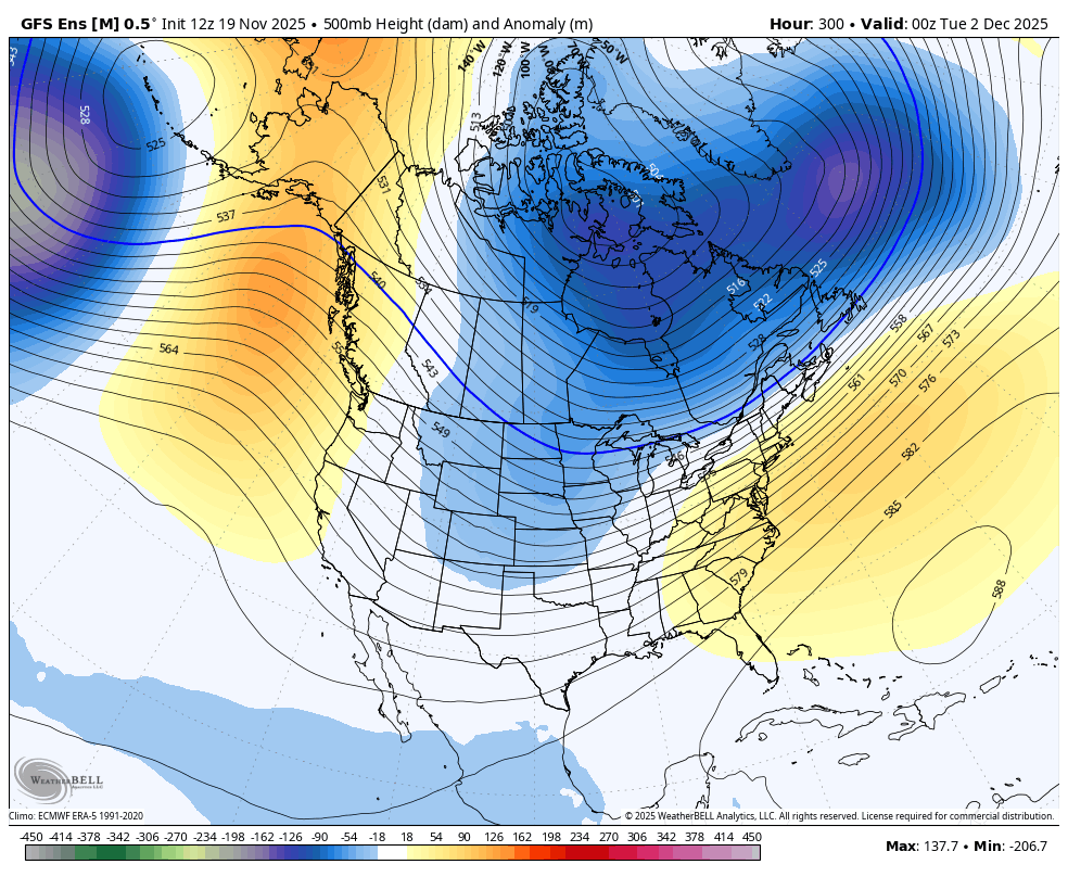
We definitely want to watch the progression of the progression of the stratosphere too. The good news is, we already have a warming event ongoing and across the Canadian Arctic If you were to follow this progression on Dr. Lawrence's site, its a longer duration event too with the peak occurring somewhere in the 300 hr time frame This is important (when the peak occurs) because this would likely result in a PV split, which begins to occur towards the end of the run Getting a PV split will be critical because the main PV looks like it could end up over Europe, but if it splits, then we could get PV displacement onto our side of the hemisphere.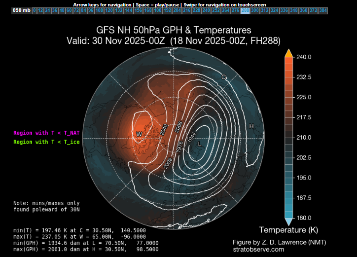
-
This is a good post imho and mirrors my general thinking:
-
November 2025 general discussions and probable topic derailings ...
Typhoon Tip replied to Typhoon Tip's topic in New England
I've noted the two pulse -EPO behavior in the ensembles. The operation Euro is an amplified outlier with the warm-roll back in between those episodes/-EPO bursts. I'm not inclined to believe it is necessarily correct. The other aspect I'd keep in mind that the models (all of them) tend to go a bit too amplified in the mid-sized spatial events. Not sure that dependable bias expresses as coherently at hemispheric scale ... just something to keep an eye on. -

2025-2026 ENSO
brooklynwx99 replied to 40/70 Benchmark's topic in Weather Forecasting and Discussion
can pretty easily see the N ATL trough feeding back on the Scandi ridge, which then increases heights in the NAO region... this elongates and presses the TPV south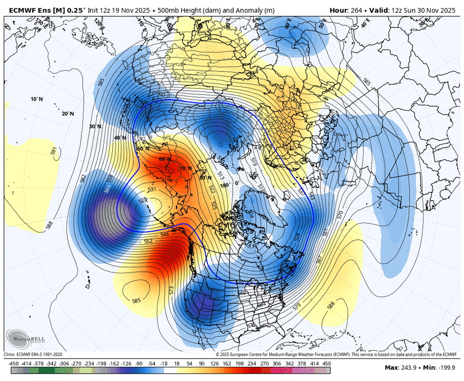
-
November 2025 general discussions and probable topic derailings ...
weatherwiz replied to Typhoon Tip's topic in New England
Let's really, really hope the PAC plays out and evolves like that. But even if it doesn't...if it can at least evolve to a degree where we can continue to further develop that later in the month...that would be a big change. I also wouldn't mind maintaining a stronger SE ridge...coastal peeps may not want that and of course that could be playing Russian Roulette but that would at least help with an active storm track with ejecting shortwaves from the southwest...then we just hope for a perfect trough axis to our west. - Today
-
2025-2026 ENSO
brooklynwx99 replied to 40/70 Benchmark's topic in Weather Forecasting and Discussion
the EPS is just a day or two slower. it gets to the same point with a -NAO developing thanks to Scandi ridging (which is typical of SSW events) -
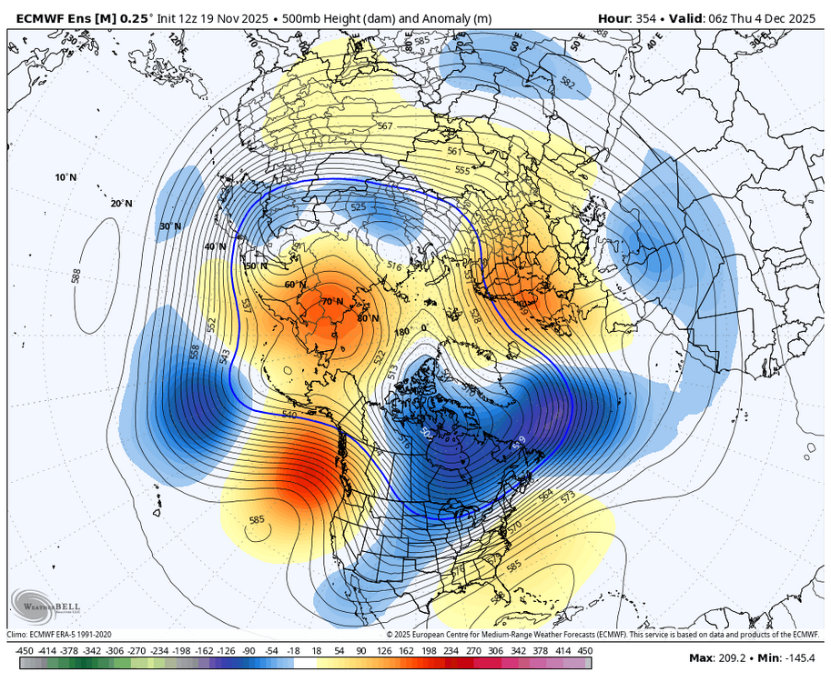
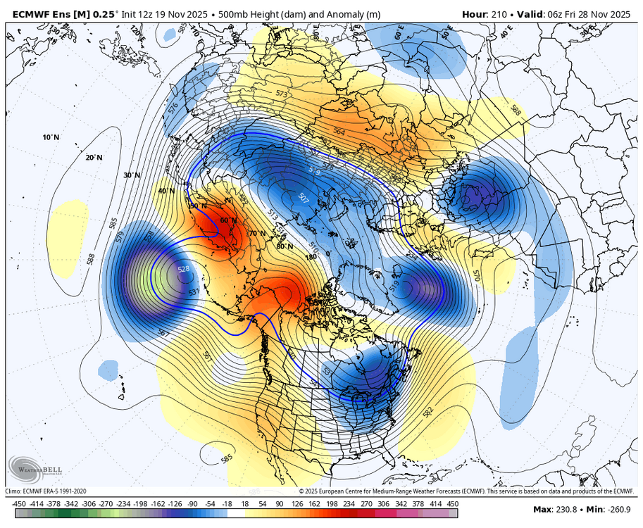
really liking the progression on all the ensembles as we head into the first week of Dec initial equatorward jet extension -> T-day trough establishes cold along with building -EPO/-WPO trough moves into the N ATL and increases Scandi ridging -> second trough dumps cold into the West and Canada second jet extension pushes cold east -> N ATL trough strengthens and starts pushing Scandi ridging into the NAO region


-
really liking the progression on all the ensembles as we head into the first week of Dec initial equatorward jet extension -> T-day trough establishes cold along with building -EPO/-WPO trough moves into the N ATL and increases Scandi ridging -> second trough dumps cold into the West and Canada second jet extension pushes cold east -> N ATL trough strengthens and starts pushing Scandi ridging into the NAO region


-
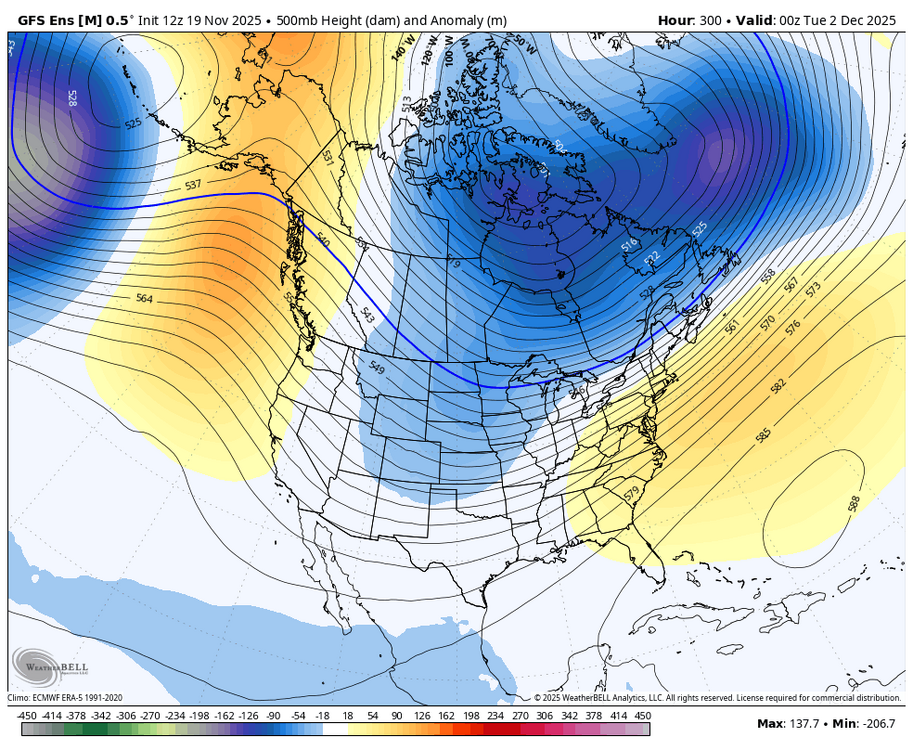
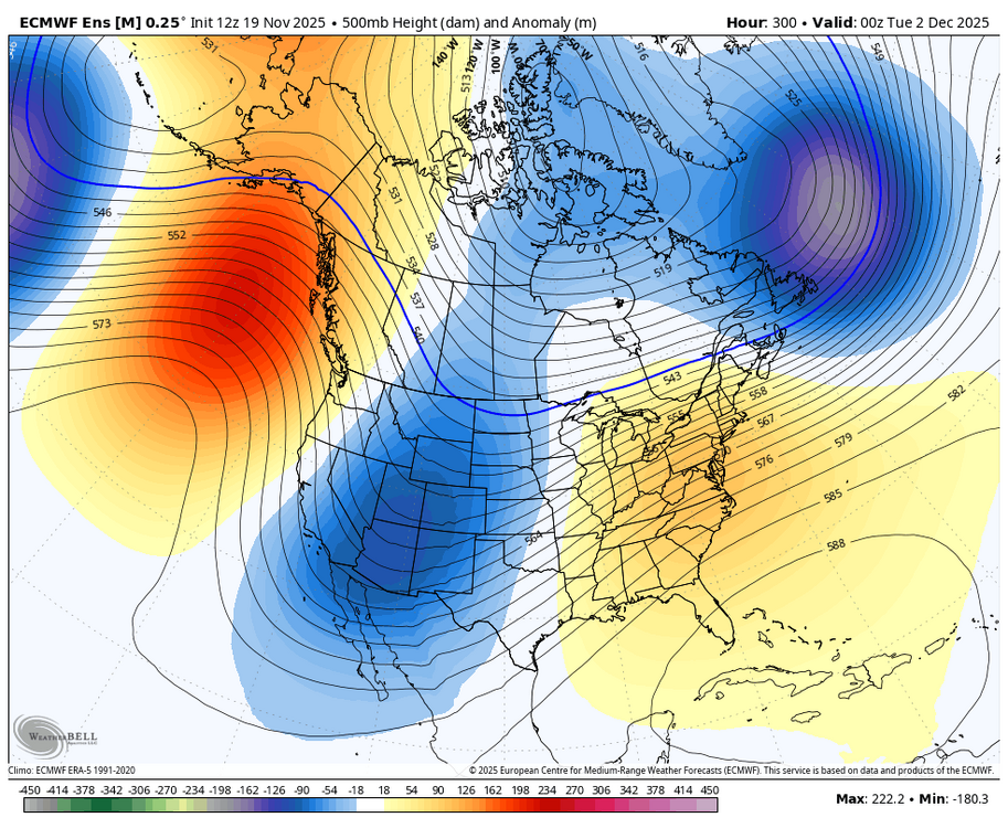
12Z ensemble means at H5 just after the cold shot at the end of Nov: GEFS: EPS: more amplified including much stronger SE ridge than GEFS: We’ll see which verifies more closely. Lately, cold has had the edge.
-

Central PA Fall Discussions and Obs
WmsptWx replied to ChescoWx's topic in Upstate New York/Pennsylvania
I'm glad PennDOT was on the ball somewhere because 453 from Water Street to Tyrone was pure, unadulterated ass this morning. -
November 2025 general discussions and probable topic derailings ...
weatherwiz replied to Typhoon Tip's topic in New England
Yup...we briefly get a shot of cold air behind the post Thanksgiving time frame and then pup heights right back up ahead of the next system. But hopefully we really do start changing things after that front later in the first week of December. Praying we really do start building heights and ridging into the West so we stop with this building heights ahead of systems, then getting a shot of cold air, only to build heights up as the next trough digging into the west translates east. If we can sustained riding in the west...we won't have to completely worry about that...especially if we can then get some Arctic support on our side. -
Central PA Fall Discussions and Obs
WmsptWx replied to ChescoWx's topic in Upstate New York/Pennsylvania
Didn't this happen in one minute via a Chinook? -
Records: Highs: EWR: 70 (1957) NYC: 72 (1921) LGA: 70 (1953) JFK: 64 (1994) Lows: EWR: 19 (1936) NYC: 18 (1936) LGA: 22 (2014) JFK: 23 (2014) Historical: 1921 - The Columbia Gorge ice storm finally came to an end. In Oregon, 54 inches of snow, sleet and glaze blocked the Columbia River Highway at the Dalles. Apart from traffic on the river itself, all transportation between Walla Walla WA and Portland OR came to a halt. Nine trains were stopped as railroads were blocked for several days. (David Ludlum) 1930: A rare, estimated F4 tornado struck the town of Bethany, Oklahoma. Between 9:30 am and 9:58 am CST, it moved north-northeast from 3 miles west of the Oklahoma City limits, and hit the eastern part of Bethany. About 110 homes and 700 other buildings, or about a fourth of the town, were damaged or destroyed. Near the end of the damage path, 3.5 miles northeast of Wiley Post Airfield, the tornado hit the Camel Creek School. Buildings blew apart just as the students were falling to the floor and looking for shelter, and five students and a teacher were killed. A total of 23 people were killed and another 150 injured, with 77 being seriously injured. Damage estimates were listed at $500,000. 1957 - Nineteen inches of snow covered the ground at Cresco, IA, a record November snow depth for the state. (The Weather Channel) 1981 - An unusually early snowstorm struck the Twin Cities of Minnesota, with as much as a foot of snow reported. The weight of the heavy snow caused the newly inflated fabric dome of the Hubert Humphrey Metrodome in downtown Minneapolis to collapse and rip. (The Weather Channel) 1987 - A sharp cold front pushed across the Great Lakes Region and the Mississippi Valley. Northwest winds gusting to 50 mph in Iowa caused some property damage around Ottumwa, and wind chill readings reached 16 degrees below zero at Hibbing MN. Showers and thunder- storms over Florida produced 5.80 inches of rain in six hours at Cocoa Beach. (The National Weather Summary) 1988 - Strong thunderstorms developed during the mid morning hours and produced severe weather across eastern Texas and the Lower Mississippi Valley into the wee hours of the night. Thunderstorms spawned twenty-one tornadoes, including thirteen in Mississippi. One tornado killed two persons and injured eleven others at Nettleton MS, and another tornado injured eight persons at Tuscaloosa AL. Thunderstorms produced baseball size hail in east Texas and northern Louisiana, and Summit MS was deluged with six inches of rain in four hours. (The National Weather Summary) (Storm Data) 1989 - Gale force winds continued to produce squalls in the Lower Great Lakes Region early in the day. Snowfall totals in western New York State reached 24 inches in southern Lewis County, with 21 inches reported at Highmarket. Unseasonably warm weather prevailed across the Northern and Central Plains Region. Eight cities reported record high temperatures for the date, including Denver CO with a reading of 79 degrees. (Storm Data) (The National Weather Summary) 2003 - Flooding affected the central Appalachians and Eastern Seaboard, with some isolated 8-inch rainfall totals across mountainous areas. There were 11 deaths caused by flooding in the region (Associated Press).
-
Pattern changes are often rushed on guidance. That’s just typical? Especially -EPO driven changes. I have been posting (along with lots of better Mets) that guidance has been overdoing mid-long range warmth for us for months now. And I personally don’t want our peak pattern on December 1. Our average high is like 52 still! I’m vey good with Thanksgiving through December 10-15 being a transitional period that builds up cold air and snowcover in our source regions.
-

November 2025 general discussions and probable topic derailings ...
Ginx snewx replied to Typhoon Tip's topic in New England
EPS unleashing some cold.png.0fc7de14c3e592431b0916c84f81c88f.png)
-
46 / 39 cloudy - should start to clear out in later this pm. https://cdn.star.nesdis.noaa.gov/GOES19/ABI/SECTOR/eus/02/GOES19-EUS-02-1000x1000.gif
-
Not this year. Things are looking quite different.