All Activity
- Past hour
-

Early Monday morning 2/16 last minute event OBS/Discussion
Kevin Reilly replied to The Iceman's topic in Philadelphia Region
Any pretty snow maps for next weekend? -
It's snowing and sticking but nothing too interesting
-
Early Monday morning 2/16 last minute event OBS/Discussion
Kevin Reilly replied to The Iceman's topic in Philadelphia Region
Moderate snow finally changed over paved areas beginning to cave. 33f humidity 99% dew point 33f The very definition of marginal Total snow: 0.02” Total Snow for Year: 25.8” -

Late February/Early March 2026 Mid-Long Range
Stormchaserchuck1 replied to WxUSAF's topic in Mid Atlantic
For those interested in the climate indexes discussion: check out 2026-2027 El Nino thread -
Snowing yey
-
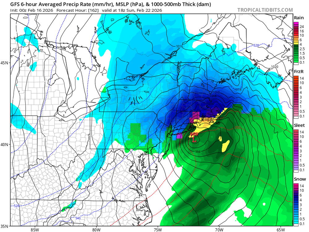
No …zoomed out I saw 946, but that was a jumble of numbers so corrected my post and image below off of ttb actual 989
-
For at least 2 years now, GFS is unreliable outside of 60 hours.
-
Exactly-There's nothing else going on-so great time to learn and discuss.
-
Pretty strong system that has a lot more juice to work with. Might be the best chance since the Jan storm.
-

Is we back? February discussion thread
RUNNAWAYICEBERG replied to mahk_webstah's topic in New England
946 ? -
I decided to look and yeah - thats a world beater. 6.2 days out so not complete lala land. 989 tucked under LI just inside the BM. Got my attention there. Lets do this and then close out Winter.
-
2026-2027 El Nino
Stormchaserchuck1 replied to Stormchaserchuck1's topic in Weather Forecasting and Discussion
I find this to be an good coincidence -- I say coincidence because the QBO is a Stratosphere index. But since the QBO 30mb data started in 1979, every single December (6) in QBO >+5 and ENSO +El Nino -- has had the same anomaly temperature pattern. There is a >80% chance this will be this upcoming December (+QBO/+ENSO). Not only is every map the same, but they are strong anomalies in the Northeast and Great Lakes in every example. Will be interesting to see what happens in December 2026: Following January in +QBO/El Nino: The map skews warmer for El Nino because the +QBO state favors a stronger Stratosphere Polar Vortex. This has correlation with +AO in the +0-day. Not a definite constant, but a higher average in the mean (deep 10mb SPV) -- El nino by itself correlates with more High pressure in the Stratosphere. -
Dusting on dirt, struggling to stick on sidewalks IMBY
-
Cmc also crushes SNE
-

Is we back? February discussion thread
Boston Bulldog replied to mahk_webstah's topic in New England
How is this thread not a 5 alarm fire after the 0z GFS!? -
If the gfs and cmc are right , Boston will have over 60 inches for the winter.
-

Is we back? February discussion thread
40/70 Benchmark replied to mahk_webstah's topic in New England
Yea, def. worth tracking. I hope I'm wrong. -

Early Monday morning 2/16 last minute event OBS/Discussion
RedSky replied to The Iceman's topic in Philadelphia Region
Its easy the old snow is solid vs this fluff -
Wish the NAO was slightly more negative . Anyway every model is on board. Fun week ahead.
-
Is we back? February discussion thread
40/70 Benchmark replied to mahk_webstah's topic in New England
It actually looks more off board to me. I don't doubt it will form....but it looks like OTS is most likely to me....another near-miss/fringe that will bomb the Maritimes. -
Dusting on all surfaces here in Brooklyn
-

Early Monday morning 2/16 last minute event OBS/Discussion
MJO812 replied to The Iceman's topic in Philadelphia Region
All the models are on board for next weekend. Decaying block and brief spike in pna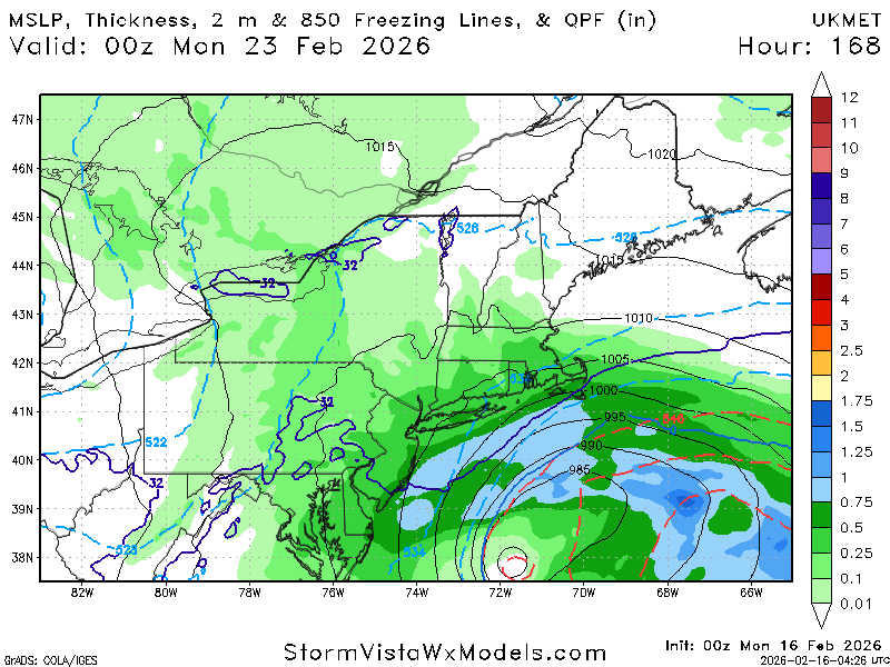
-
Gfs is on its own with that run. Canadian and Icon look like forecasts for different planets. Problem is all 3 of those models stink, so...?
-

Early Monday morning 2/16 last minute event OBS/Discussion
The Iceman replied to The Iceman's topic in Philadelphia Region
Im sure that won’t change maybe a half inch so far? Coating over everything. Pillow flakes -
Ukie is also on board for the 23rd. All the models are on board for a possible coastal storm. We have to watch this closely . Decaying block and brief spike in PNA.


