All Activity
- Past hour
-
 http://menon36.com/# Cialis 20mg price
 -

Septorcher 2026 Discussion - Endless Summer
ineedsnow replied to Damage In Tolland's topic in New England
Euro and ICON are kind of meh! But the GFS, Euro AI, GFS AI , and EPS are all showing it.. it could be a fun storm - Today
-
.thumb.jpg.6a4895b2a43f87359e4e7d04a6fa0d14.jpg)
Central PA Summer 2026 Discussion/Obs Thread
Yardstickgozinya replied to Voyager's topic in Upstate New York/Pennsylvania
https://forecast.weather.gov/product.php?site=CTP&issuedby=CTP&product=AFD&format=CI&version=1&glossary=1&highlight=off -- Highlight Changed Discussion -- 515 FXUS61 KCTP 190506 AFDCTP Area Forecast Discussion National Weather Service State College PA 106 AM EDT Sat Sep 19 2026 .WHAT HAS CHANGED... * No sig changes && .KEY MESSAGES... 1) Becoming noticeably less humid through the day today with cooler air settling in for tonight. 2) Rain returning by Sunday, heavy at times. 3) Rainy pattern continues into much of next week. && .DISCUSSION... KEY MESSAGE 1: Becoming noticeably less humid through the day today with cooler air settling in for tonight. With the cold front now pushing into the southern tier, high clouds are peeling off to the south. However, moisture remains trapped in the boundary layer resulting in widespread stratus and a few areas of fog. Dewpoints range from the upper 60s to the low 70s in these predawn hours. Showers are expected to remain isolated at best. A north breeze with gusts up to 20 mph will advect a cooler and drier air mass, with temps and dewpts in the 40s for central PA by late tonight. Patchy valley fog is possible early Saturday morning. Most, if not all of Saturday will be dry. ------------------------------------------------------------- KEY MESSAGE 2: Rain returning by Sunday, heavy at times. Periods of potentially heavy rainfall are expected Saturday night into Sunday. Both NAEFS and ECMWF SATs show at least 90th percentile PWs returning to the region, which is supportive of at least a marginal excessive rain signal. A surface low expected to track over the Great Lakes will usher in this moisture and more than enough forcing for widespread precipitation. A few to several hundred J/kg of MUCAPE should support some heavier downpours, but little to no CAPE above the -10C level suggests the lightning threat will be limited. Most likely rainfall amounts with the Sunday system are 0.50-1.50". ------------------------------------------------------------- KEY MESSAGE 3: Rainy pattern continues into much of next week. PoPs are progged to drop into the 30-40 pct range on Monday as high pressure wedges in from the north. However, the jet stream will remain active and amplified with Pacific disturbances moving across the nation. By Tuesday, most guidance has a slow moving trough in the Ohio Valley advecting warm air above a wedge of cool sfc air in place from the aforementioned high pressure system. This setup may linger for a few days, with up to several inches of rainfall possible through the week. The cold air damming will also result in high temps only in the 50s to low 60s. && -
Buy Viagra online cheap or Cheap Sildenafil 100mg order viagra http://eu-clearance.satfrance.com/?a[]= Buy Viagra online cheap or https://exhibitioncourthotel4.co.uk/user-2/sjscclddcm/?um_action=edit Order Viagra 50 mg online [url=http://maps.google.com.na/url?q=https://getbelvion.shop]cheap viagra[/url] viagra canada or [url=https://vintage-car.eu/user/vsedcapduf/]best price for viagra 100mg[/url] Cheap Sildenafil 100mg
-
Generic Tadalafil 20mg price: MenOn 36 - Tadalafil price
-
0z Models are back to being wetter for next week. Coastal is closer to the coast.
-
 -42.37 SOI today. 4th consecutive day <-30 September is -23 to date.
 -
http://getbelvion.com/# over the counter sildenafil
-
Buy Cialis online: MenOn36 - Buy Tadalafil 10mg
-

Septorcher 2026 Discussion - Endless Summer
vortex95 replied to Damage In Tolland's topic in New England
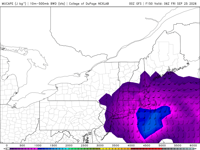
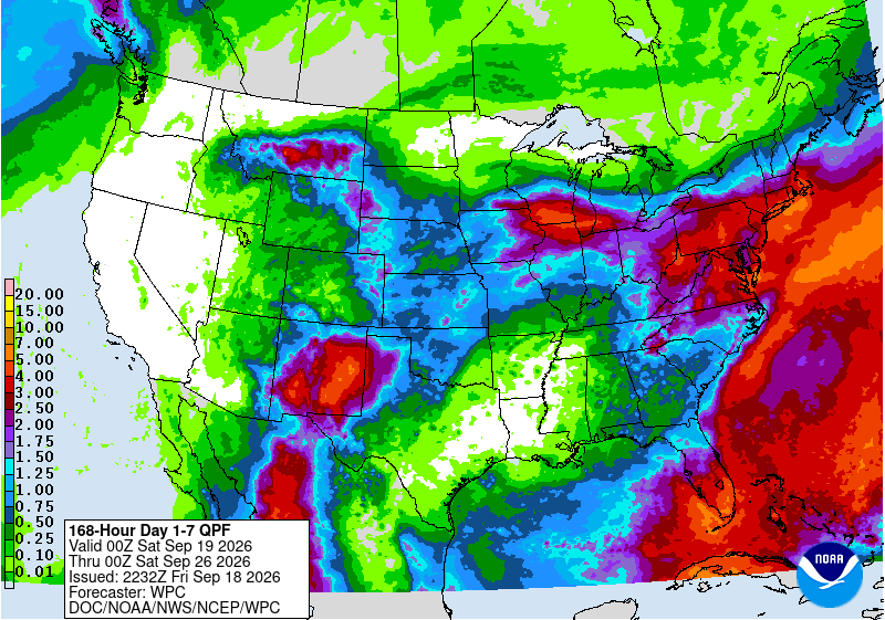
@CoastalWxPT time in Weymouth? 00z GFS all in. WPC in their 7-day pcpn totals likes it! And that's a lot of CAPE for a Nor'easter. Lots of embedded tstms and good mixing down of BL high winds. Why not? It's Sep w/ SSTs highest and there is a sig area 100-150 mi S and E of CC of anomalies up to +4 C! @weatherwiz @ineedsnow getting ready. Sfc low not that deep but when it is 1004, 1033 high in Quebec due N, so outstanding gradient and fetch for a Sep nor'easter. I don't recall anything quite like this in Sep in recent times, but I'll let others chime in on that for historical context! Only thing missing is some isolate pockets of of 0 C at 850 in NNE, but it does get down to +3 C even in MA.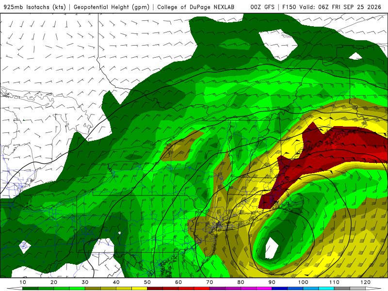
-
Watch off the E coast next week. Here’s a hint of that from 0Z Uk: NEW TROPICAL CYCLONE FORECAST TO DEVELOP AFTER 150 HOURS FORECAST POSITION AT T+150 : 36.1N 70.8W LEAD CENTRAL MAXIMUM WIND VERIFYING TIME TIME POSITION PRESSURE (MB) SPEED (KNOTS) -------------- ---- -------- ------------- ------------- 1200UTC 25.09.2026 156 36.9N 69.7W 1000 47 0000UTC 26.09.2026 168 39.1N 67.9W 997 41
-
Buy Viagra online cheap: GetBelvion - cheapest viagra
-
2026 Atlantic Hurricane Season
vortex95 replied to Stormchaserchuck1's topic in Tropical Headquarters
@WEATHER53, you are not wrong in your observation here. ----- Now, first let me say I don't want what I say below cause a flare-up b/c of the topical item was mentioned in the quoted posts above. I am listing objective, factual statistics below that provide context and perspective only and inform about some things some may not know or realize when it comes to TC records/stats in the Atlantic. ----- After the record 2005 season, things shutdown big time for landfalls in the CONUS, setting a record on the other end of the spectrum. After Wilma's landfall in Oct 2005, the CONUS went 11.5 years w/o a major hurricane landfall, which is the longest period on record going back to 1851. And the period 1995-2016? 3 of 32 hurricanes in the Atlantic had a CONUS major landfall 1995-2003, 7 of 13 2004-2005, and 0 of 29 from 2006-2016. So it was all focused in one big 2-year period, and atypically quiet either side for 20 seasons for CONUS landfalls. We hear plenty of talk on how active things have been recently, and it indeed has, but often I find little context and perspective given in reports, not only from a historical point-of-view, but also records that display atypical inactivity in recent decades. If you are going to talk about trends/changes, all relevant and reasonable information/data should be presented/provided, not cherry-picked. Facts are meaningless w/o context. I would also caution about falling into the recency bias trap when it comes to wx events. It is cognitive shortcut where people give more importance and weight to recent events, experiences, or information than to prior or historical data. Here is a good example: The 10-year period 2015-2024 had 25 CONUS hurricane landfalls. However, the record in a 10-year period is 27 1879-1888. So what has happened recently for CONUS hurricanes landfalls is not unprecedented. And if you look at events that occurred long ago that have no equal in recent decades? * Two category 3 hurricanes (both 110 kt) made landfall 23 hours apart in the U.S. in Sep 1933 (Jupiter FL and Brownsville TX). Nothing else even close to this exists in the record. * There are only 5 known Atlantic hurricanes to occur in May since 1851. Last time there was one was in 1970. The strongest was in 1863, which made landfall as category 2 in the FL Panhandle, making it the earliest landfall CONUS hurricane on record. * The last June CONUS hurricane landfall was in 1986. This is the longest stretch w/o a June CONUS landfall on record. * In June 1886, 3 hurricanes made landfall in the U.S. No other June has had more than 1. * New England had 5 hurricane landfalls in a 23-year period 1938-1960. None have occurred for 35 years 1991-2026, which is the longest period on record for the region. -
Yea, this is what I was getting at....maybe it won't be pretty, but it will be a +PNA.
-
The 0z is the best gfs run yet for a region wide soaking.
-
A very welcomed change!
-
Picked up 0.31” here, brings MTD total to 1.90”
-
Cialis 20mg price in USA: MenOn 36 - п»їcialis generic
-
Cialis 20mg price and Cialis without a doctor prescription Tadalafil Tablet http://gambling-trade.com/cgi-bin/topframe.cgi?url=http://menon36.shop/ Generic Tadalafil 20mg priceor https://brueckrachdorf.de/user/pwslgyixxa/ Generic Tadalafil 20mg price [url=https://images.google.com.fj/url?q=https://menon36.shop]Tadalafil Tablet[/url] Generic Cialis without a doctor prescriptionor [url=https://brueckrachdorf.de/user/wcdtwapkie/]Cialis without a doctor prescription[/url] Cialis 20mg price in USA
-
Where the heck are you in Mt Ulla? Got 0.01" here and 1.27" for the month. I'm here near the elementary school.
-

Septorcher 2026 Discussion - Endless Summer
tiger_deF replied to Damage In Tolland's topic in New England
IF we're looking for interesting weather over the next few weeks, best combination would be the 5 days of moisture train panning out, combined with a subtropical/somewhat tropical development off the SE coast coming north over the next week or two. Other than that we may be kvetching until the first proper nor'easter. -
-
-
CPC's PNA index is a little weird, DJFM 23-24 was 4/4 +PNA months, totaling +2 and the overal H5 for it was a +45dm ridge south of the Aleutian islands... kind of a big difference. In Jan 2025 there was a +200dm ridge and they were saying it was +PNA.
-
Closer to neutral doesn't mean -PNA but there is a tendency in those two months.