All Activity
- Past hour
-
-
Some of these people are nuts. Many area's during the crap stretch have gotten a 4" snowfall or more within a 15 mile radius of NYC. NYC had bad luck during those storms, mostly because of the storm track being a tiny bit off for them. I went over it several times, but some are just too stubborn.
-
ALEET
-

November 2025 general discussions and probable topic derailings ...
WinterWolf replied to Typhoon Tip's topic in New England
I feel the take away is, things are heading in a decent direction it seems, and the chances are now just starting to show up. This is good. -
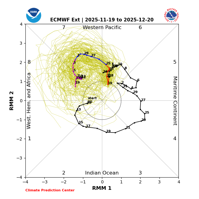
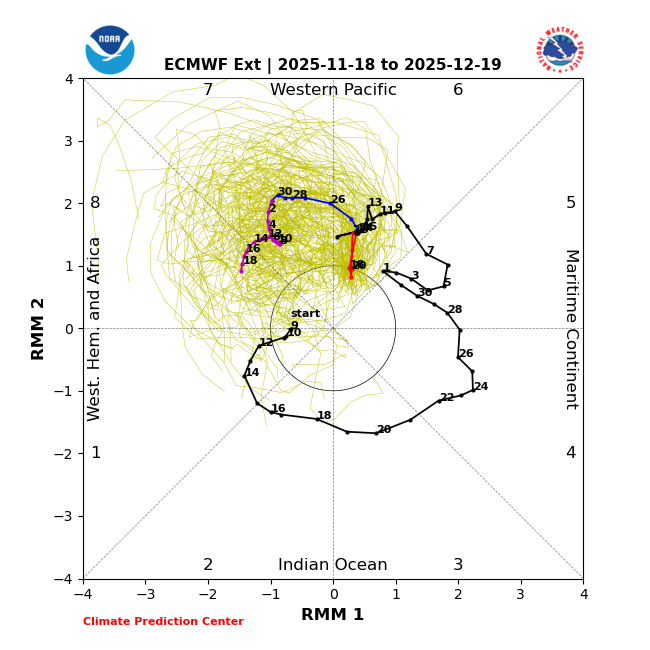
Today’s GEFS gets to phase 7 a day earlier than yesterday’s (11/28 vs 11/29) and three days earlier than the run from 2 days ago. The 11/19/25 Euro-ext gets it to phase 8 ten days earlier (12/5) than the prior run (12/15): Prior run (11/18/25):
-
Warming events don't happen in the Summer. You mean in June in the South Pole?
-

Central PA Fall Discussions and Obs
Jns2183 replied to ChescoWx's topic in Upstate New York/Pennsylvania
Those guys have caused me to spend a few weeks on antibiotics over the years. I now only hike wearing pants and long sleeves Sent from my SM-G970U1 using Tapatalk -

November 2025 general discussions and probable topic derailings ...
CoastalWx replied to Typhoon Tip's topic in New England
With it being early in the season, 2 to 4 inches would be epic. -
You don't need a 500mb -NAO to have 10mb warming. Actually history is full of examples where the two are at odds. It correlates +40dm -NAO at Day+0, but a +100dm -NAO at ~+30 days (+25-35 days), which is the end of December. Let's see if we get a 2nd -NAO period later in Dec.
-
Yeah, you would expect the fall low so far to eventually get down into that range. Not really cold by their standards over the short period of record since 1998. They got much colder in the fall of 2018 down to -21° on 11-23-18. Time Series Summary for SARANAC LAKE ADIRONDACK REGIONAL AP, NY - Sep through Nov Lowest Temperature Click column heading to sort ascending, click again to sort descending. 2025 2 11 2024 13 0 2023 4 0 2022 0 0 2021 -2 0 2020 3 0 2019 -9 0 2018 -21 0 2017 -3 0 2016 18 0 2015 9 0 2014 -3 2 2013 -13 0 2012 -4 0 2011 9 0 2010 2 0 2009 12 0 2008 1 0 2007 1 0 2006 11 1 2005 0 1 2004 3 0 2003 -1 1 2002 -9 0 2001 5 0 2000 -10 1 1999 -3 2 1998 6 Station Thread for Saranac Lake Area, NY Name Period in Thread 1 Saranac Lake Adirondack Regional Apt 06/01/1998 to 12/31/2024 2 Ray Brook 04/01/1978 to 05/31/1998 3 Gabriels 09/01/1966 to 03/31/1978 4 Paul Smiths 07/01/1949 to 08/31/1966 5 Gabriels 09/01/1908 to 09/30/1948 6 Paul Smiths 03/01/1903 to 08/31/1908
-
Did he? It was on models, now they have some pretty good +NAO troughing near Greenland with ridging underneath of it on the east coast. I think we are still below average temps though during the ridge because of -epo/+pna at the time.
-
Lol what an absurd post, my god. 10 inches fell in Florida last winter, you think NYC can no longer get 4 inches in one event? There has been two events at JFK over 4 inches during this crap stretch, one of them being over 6 inches.
-

-
How much difference can there be between ground level and 2 meters? I remember when we had our burst of snow last week in the morning, my thermometer showed 33 degrees but I had a small puddle of water on a garden supplies container frozen.
-
Yeah it looks like it is MJO driven. The good news is the Pacific continues to act more like "Neutral ENSO" than La Nina. CPC PNA has been positive 21 of the last 29 months, and 12 of the last 19 months since the 23-24 El Nino ended. The 23-24 Strong Nino I believe changed something. I've watched it difficult for N. Pacific ridges to establish and sustain all year. ENSO does correlate the highest in Jan-Feb, but this is a pretty good +PNA now on models for the last week of Nov and early Dec... We had 8 straight +AO months earlier this year. We had 7 straight +NAO months until 2 months ago. The Atlantic side is not in a long term -NAO state, and it's decadal fluctuation index, so the consistency is important. That's why a good month of solid -NAO (2nd half of Nov in December) was looking good! Some change! It's kind of the same pattern happening. Maybe the Stratosphere warming will turn the NAO back negative in the 2nd half of December, but that's because of something, not a default state, which I was hoping for. I still think we see -AO tendency this Winter because of low N. Hemisphere 500mb heights in the Summer and Fall.
-
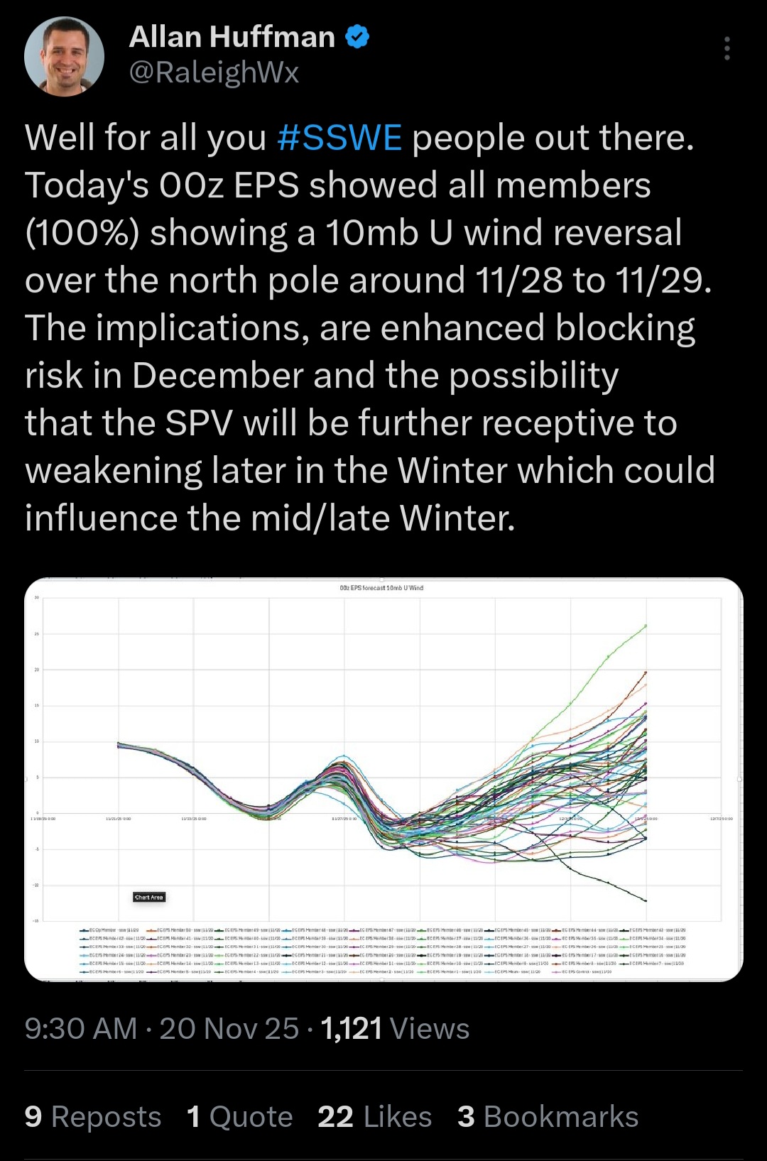
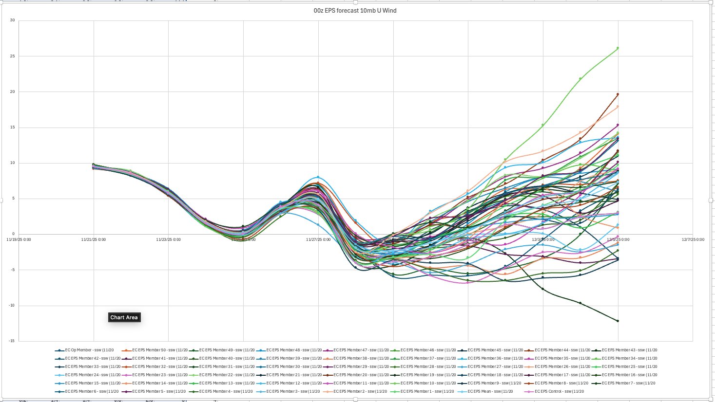
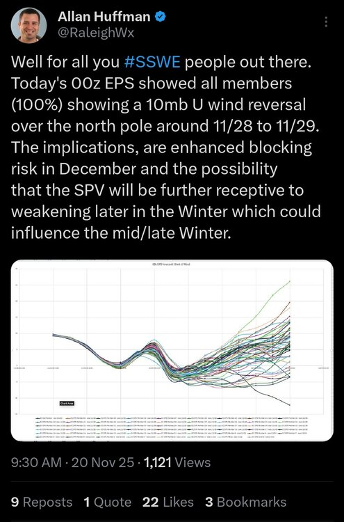
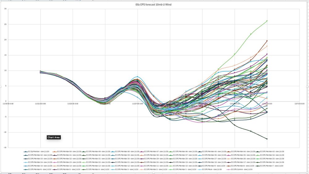
Allan Huffman @RaleighWx 22m Well for all you #SSWE people out there. Today's 00z EPS showed all members (100%) showing a 10mb U wind reversal over the north pole around 11/28 to 11/29. The implications, are enhanced blocking risk in December and the possibility that the SPV will be further receptive to weakening later in the Winter which could influence the mid/late Winter.
-
Do you think the atmosphere is still capable of producing 4" of snow in a single day at locations like New York and Pittsburgh (see below)? I noticed Pittsburgh has obliterated its longest stretch without 4" of snow, and this includes data from the downtown station that was a few hundred feet lower in elevation with a seasonal snowfall average of about ~12 inches less than the airport. So this is completely unprecedented since at least the 1870s. I have to wonder if the 40N parallel is simply too for south to see such heavy snow with the current atmospheric conditions? Maybe NYC will fare a little better being on the coast?
-
Warming events taking place at both the North Pole and the South Pole with assist the MJO in progressing into phase 8 in December.
-
Didn't Webb say the - NAO was going to lock in ?
-
35.6 for the low. currently sitting at 41.2 here in 21057
-
Correct me if I'm wrong, but essentially what you're saying is that we’ll probably still get colder later in December, but the pattern is now looking less “textbook perfect” than it did before; it looks more like a pattern driven mainly by the MJO rather than a more powerful and sustained cold setup from both the Pacific and the Atlantic.
-

Pittsburgh PA Fall 2025 Thread
TheClimateChanger replied to TheClimateChanger's topic in Upstate New York/Pennsylvania
It's been an incredible 1,348 days since the last calendar day with 4" of snow. You have to think eventually that breaks, or do you guys think it is no longer possible to see 4" of snow in a single day at PIT? -
The Pacific looks good with MJO going through Phase 7 and possibly Phase 8.. models are developing and have trended toward a +PNA pattern. The Atlantic was looking blocky earlier in the month and that was exciting because it was associated with a Stratosphere warming to help sustain the pattern until possibly early January. In the last few days a big +NAO appeared in the medium range, and the 10mb warmings doesn't look as strong, although it's still a Strat warming happening. We will probably get colder later in the month, but it kind of has a bad taste when the fundamentals were looking so good, now it's just a MJO-amped pattern and nothing more. By fundamentals I mean holding a -NAO for more than 10 days.
-
Is December looking less and less good (because it seems like the beginning of the month has trended warmer), or is it just models rushing the pattern change like usual?
-

November 2025 general discussions and probable topic derailings ...
tamarack replied to Typhoon Tip's topic in New England
Low here was 14, coldest of the season by 6° but nothing special for November. Median for November's lowest is 8, range is 17 (twice) and -4. Pure blue and no wind this morning.