All Activity
- Past hour
-
Would you say a 2016 level event is still on the table? (Or given ENSO 1996)
-

“Cory’s in LA! Let’s MECS!” Jan. 24-26 Disco
weatherwiz replied to TheSnowman's topic in New England
I see it now...I looked further ahead to Sunday with I guess if you want to call it the second wave -
EPS-AI is wetter than regular EPS now (or maybe also was before and I didn’t notice). Colder too at 850.
-

Pittsburgh/Western PA WINTER ‘25/‘26
Burghblizz replied to Burghblizz's topic in Upstate New York/Pennsylvania
Who was the one having lunch? I think that was probably an intentional exaggeration to highlight he thought it still might be come NW -

Possible Record Breaking Cold + Snow Sunday 1/25 - Tuesday 1/27
NEG NAO replied to TriPol's topic in New York City Metro
who gets 20 ? -
.thumb.jpeg.406ecda2eec9e267302c22b9f128fe3c.jpeg)
“Cory’s in LA! Let’s MECS!” Jan. 24-26 Disco
kazimirkai replied to TheSnowman's topic in New England
Alot of my weather friends from Stony brook and Albany are heading down to AMS this weekend and they're all hoping for ice there to at least see some winter precip out of this huge storm. Pretty tragic situation for them if its all rain -
From 3 to 34 here. Really looking forward to tomorrow's 50F
-

Possible Record Breaking Cold + Snow Sunday 1/25 - Tuesday 1/27
TriPol replied to TriPol's topic in New York City Metro
There is no model showing 6 inches of snow for nyc right now. Nothing. Zero. We can all appreciate your need to stay conservative, but we should also stay reasonable. -
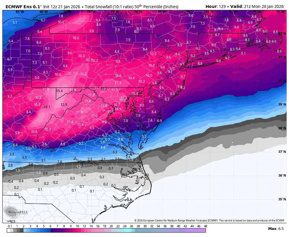
EPS 50% snowfall, this is an under utilized tool. Often when we see high snowfall means the 50% is much lower...indicating totals are skewed by outliers. That is a red flag that the high snowfall outcome is not necessarily the most likely outcome. In this case the 50% is higher than the mean, which is unusual, and a good sign.

-

2025-2026 Fall/Winter Mountain Thread
Maggie Valley Steve replied to Buckethead's topic in Southeastern States
Afternoon update Day 4 Outlook for snow..gif.12766f60d088b3c53d6bac4fbc0b65dd.gif)
-
Euro seems to look solid for the metros.
-

“Cory’s in LA! Let’s MECS!” Jan. 24-26 Disco
WeatherGeek2025 replied to TheSnowman's topic in New England
thanks i got an instagram page u can follow... @nycweathernow -
Just to put it out there, the 18z HRRR is riding on the “slow Baja low” side of the guidance envelope
-

“Cory’s in LA! Let’s MECS!” Jan. 24-26 Disco
The 4 Seasons replied to TheSnowman's topic in New England
They issue winter storm watches when a cold win blows down there -
 On the road and can’t check anything on eps and ai ensembles? Does it show mixing like operational?
 -
“Cory’s in LA! Let’s MECS!” Jan. 24-26 Disco
weatherwiz replied to TheSnowman's topic in New England
Wow I'm shocked to see Winter Storm Watch as far south as Houston (looks like for ice)...I don't see anything indicating they will get icing that far south. I know that far south it takes like 3 drops of frozen liquid but very odd -

Possible Record Breaking Cold + Snow Sunday 1/25 - Tuesday 1/27
eduggs replied to TriPol's topic in New York City Metro
True worst case from 4 days out is almost always 0. A reasonably plausible low low end is probably in the range of 2-4". A baseline target would be 6". -
 Not in a mixing scenario. That happens all the time!
 -

Possible Record Breaking Cold + Snow Sunday 1/25 - Tuesday 1/27
Prue11 replied to TriPol's topic in New York City Metro
Central Park 3” everywhere else 1-2’ lol -
New thread
-
SST's on the bay are already pretty cold from December, and depending on how cold the 1"+ QPF that falls on it is it should start icing up quicker than people would think
-
Pee Dee is a large area and .60 of ice taken verbatim will be an issue. Please do not take any of these clown maps seriously. There are many many factors that these maps don’t take into consideration.
-

“Cory’s in LA! Let’s MECS!” Jan. 24-26 Disco
Henry's Weather replied to TheSnowman's topic in New England
Apart from amount discontinuities and insane totals, decent job on the graphics man -
“Cory’s in LA! Let’s MECS!” Jan. 24-26 Disco
weatherwiz replied to TheSnowman's topic in New England
Right Probably something you'd see in like central Alaska lol -
New thread ahead of 18z runs. A reminder: Keep banter to a bare minimum put at least some effort into explaining your thoughts If your posts keep disappearing, take note. Moderation will be much stricter, but not too restrictive.