All Activity
- Past hour
-
Based on NWS radar loop, it appears to be snowing along the M/D already - although it could be virga. Precip field has really blossomed the last couple of hours.
-

Feb 22nd/23rd "There's no way..." Obs Thread
EHoffman replied to Maestrobjwa's topic in Mid Atlantic
I have zero expectations with this storm. Everything is stacked against a meaningful snow, at least in DC proper. The warning map is fucking sad. Maybe I'll be pleasantly surprised tomorrow, but I doubt it. On that note, it's about to start raining -
Yup don't recall a setup in recent memory where the Warning map nearly encircled DC as it does now. Sad
-

“Cory’s in NYC! Let’s HECS!” Feb. 22-24 Disco
weathafella replied to TheSnowman's topic in New England
Torchy why are you giving me multiple confused? -
“Cory’s in NYC! Let’s HECS!” Feb. 22-24 Disco
weathafella replied to TheSnowman's topic in New England
Are you in a position by location to be deformed? -

“Cory’s in NYC! Let’s HECS!” Feb. 22-24 Disco
40/70 Benchmark replied to TheSnowman's topic in New England
I'm over 1" now....about 1.1" -

Feb 22nd/23rd "There's no way..." Obs Thread
SNOWCREATURE1 replied to Maestrobjwa's topic in Mid Atlantic
One of the finest phrases ever - should be etched in stone! -
“Cory’s in NYC! Let’s HECS!” Feb. 22-24 Disco
weathafella replied to TheSnowman's topic in New England
If you have it now you’ll probably have it then. -
“Cory’s in NYC! Let’s HECS!” Feb. 22-24 Disco
weathafella replied to TheSnowman's topic in New England
Can you translate? Google translate didn’t compute -

Feb 22nd/23rd "There's no way..." Obs Thread
ravensrule replied to Maestrobjwa's topic in Mid Atlantic
This is beyond brutal. URGENT - WINTER WEATHER MESSAGE National Weather Service Baltimore MD/Washington DC 1250 AM EST Sun Feb 22 2026 DCZ001-MDZ013-016-504-VAZ053-054-526-527-221400- /O.CON.KLWX.WW.Y.0011.260222T2200Z-260223T1500Z/ District of Columbia-Prince Georges-Charles-Central and Southeast Montgomery-Fairfax-Arlington/Falls Church/Alexandria-Northwest Prince William-Central and Southeast Prince William/Manassas/Manassas Park- 1250 AM EST Sun Feb 22 2026 ...WINTER WEATHER ADVISORY REMAINS IN EFFECT FROM 5 PM THIS AFTERNOON TO 10 AM EST MONDAY... * WHAT...Snow expected. Total snow accumulations between 2 and 4 inches. Winds gusting as high as 35 mph. * WHERE...Washington DC, and portions of central and southern Maryland, and northern Virginia. * WHEN...From 5 PM this afternoon to 10 AM EST Monday. * IMPACTS...Plan on slippery road conditions. The hazardous conditions could impact the Monday morning commute. -
"I'm playing both sides that way I always end up on top" [emoji23] Sent from my SM-F966U1 using Tapatalk
-

Central PA Winter 25/26 Discussion and Obs
MAG5035 replied to MAG5035's topic in Upstate New York/Pennsylvania
Pretty good start so far… moderate rate and 31ºF. About a half inch on non paved surfaces. -

Feb 22nd/23rd "There's no way..." Obs Thread
stormtracker replied to Maestrobjwa's topic in Mid Atlantic
I’m not even there and i feel sad for my hometown. We’re the only ones in the megalopolis left out and we got the Temu of weather warnings. Shit is legit sad. -
Feb 22nd/23rd "There's no way..." Obs Thread
ravensrule replied to Maestrobjwa's topic in Mid Atlantic
URGENT - WINTER WEATHER MESSAGE National Weather Service Baltimore MD/Washington DC 1250 AM EST Sun Feb 22 2026 MDZ005-006-008-011-014-017-018-505>508-221400- /O.CON.KLWX.WS.W.0003.260222T2000Z-260223T1500Z/ Carroll-Northern Baltimore-Cecil-Southern Baltimore-Anne Arundel- St. Marys-Calvert-Northwest Howard-Central and Southeast Howard- Northwest Harford-Southeast Harford- 1250 AM EST Sun Feb 22 2026 ...WINTER STORM WARNING REMAINS IN EFFECT FROM 3 PM THIS AFTERNOON TO 10 AM EST MONDAY... * WHAT...Heavy snow expected. Total snow accumulations between 5 and 10 inches. Locally higher amounts up to 14 inches are possible in northeast Maryland. Winds gusting as high as 35 mph. * WHERE...Portions of north central, northeast, and southern Maryland. * WHEN...From 3 PM this afternoon to 10 AM EST Monday. * IMPACTS...Travel could be very difficult. The hazardous conditions could impact the Monday morning commute. -

“Cory’s in NYC! Let’s HECS!” Feb. 22-24 Disco
Scott Koziara replied to TheSnowman's topic in New England
When I'm pushing 80 I hope to have your love of life! -
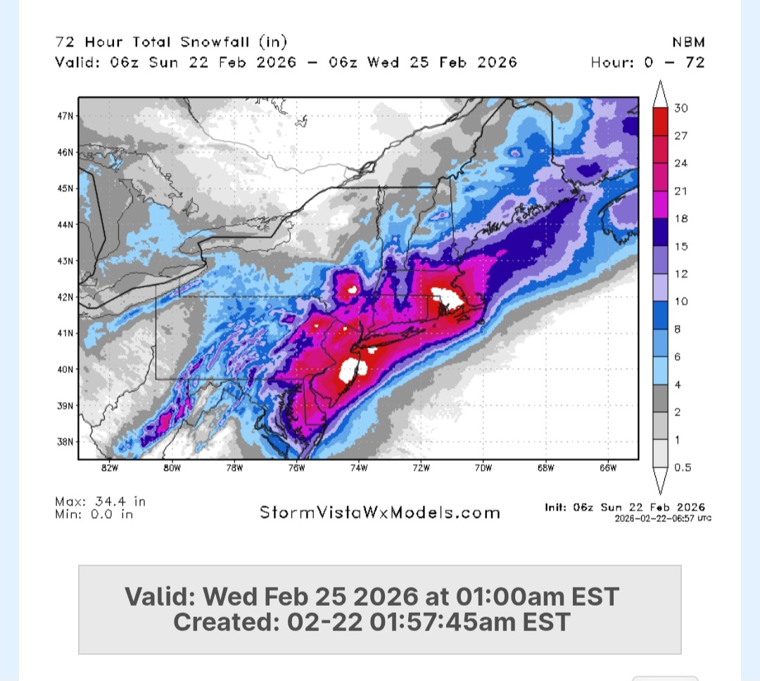
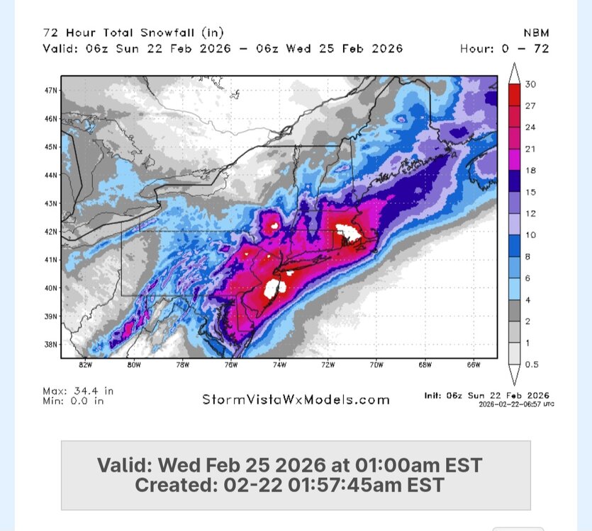
Latest NBM
-

“Cory’s in NYC! Let’s HECS!” Feb. 22-24 Disco
WinterWolf replied to TheSnowman's topic in New England
Juicing up….we juice. -
Idk anyone who thinks this will drop 40 inches but 20"+ is certainly a decent possibility.
-

“Cory’s in NYC! Let’s HECS!” Feb. 22-24 Disco
Torch Tiger replied to TheSnowman's topic in New England
looks mid -
Nam is too aggressive imo
-
“Cory’s in NYC! Let’s HECS!” Feb. 22-24 Disco
weathafella replied to TheSnowman's topic in New England
Home. Lots of snow otg! Tomorrow night through Monday should rock. -

“Cory’s in NYC! Let’s HECS!” Feb. 22-24 Disco
metagraphica replied to TheSnowman's topic in New England
32/30. Light snow/drizzle for the past couple of hours. Some kind of weird low level precip.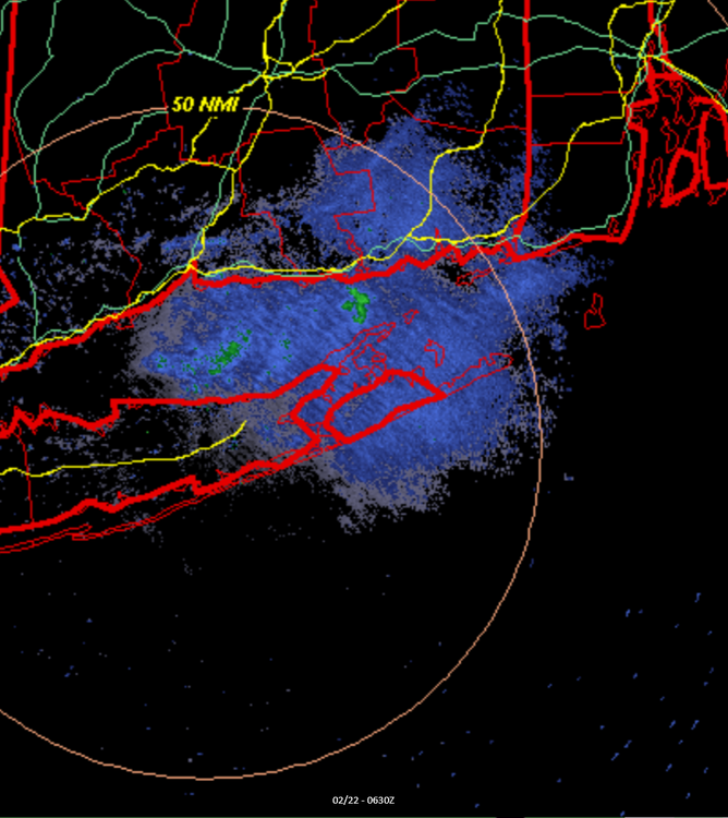
-
much lower in certain areas especially the ocean county coast VS. the NAM
-

“Cory’s in NYC! Let’s HECS!” Feb. 22-24 Disco
WxWatcher007 replied to TheSnowman's topic in New England
Not that it matters at this point but here is the EPS. 12z 00z -
12/30/00 was sure as hell no change to sleet and that must've been 4" per hour when it was the once I heard thundersnow. Was literally blinding heavy snow. The rain line wasn't too far east in Suffolk County, Long Beach lucked out for once that day.