All Activity
- Past hour
-
I'm hoping the recon data the GFS ingested is giving us a more accurate solution
-
This may be the best gfs run we have seen… .
-

January 2026 regional war/obs/disco thread
moneypitmike replied to Baroclinic Zone's topic in New England
I can't believe Mattapoisett will be getting double digits and I'll have nothing here in Maine. We're doing okay overall up here, but it will be painful sitting this one out. Congrats you southerners. -
Out to 90 the 6z GFS keeps NC all snow. Upstate area of SC is also snow but on the edge. GA mainly ZR.
-

January 2026 regional war/obs/disco thread
ineedsnow replied to Baroclinic Zone's topic in New England
6z ICON was looking good -
6z GFS looks better than the Euro out to 84. Front end thump of snow inbound for upstate SC and most of NC.
-
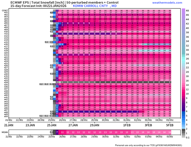
One thing to see that wild. Almost every member shows over 10”.
-

January 2026 regional war/obs/disco thread
Damage In Tolland replied to Baroclinic Zone's topic in New England
1-3 tonight . Feet Sunday/ Monday/ Tuesday -
I see we’ve had a north trend where we flirt with mixing or do mix before the storm ends. I knew it. But still a good front ender.
-

January 25/26 Jimbo Back Surgery Storm
NorthHillsWx replied to Jimbo!'s topic in Southeastern States
@eyewall the 6” snow probability for Raleigh is at 0% on the 0z EPS for Raleigh. We’re totally cooked -
January 25/26 Jimbo Back Surgery Storm
NorthHillsWx replied to Jimbo!'s topic in Southeastern States
ICON much more amped. Big jump north again. Basically no snow in NC even at border. Holds the wedge, crippling ice. -
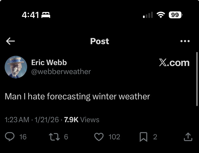
Eric Webb getting served crow via 0z models.
-
Good thump for most of the sub, 8-12” before the lowlanders SE of 95 would have mixing issues. Transfers to a low off VA near the end of the run, but cuts off for most at hour 120. Not at the computer for nice graphics, trying to log into wxmodels site to paste a total QPF/snow, but hasn’t loaded there yet.
-

Central PA Winter 25/26 Discussion and Obs
Voyager replied to MAG5035's topic in Upstate New York/Pennsylvania
Cracked the zero mark sometime overnight. Now sitting at -2.9 in my backyard. At my colder location shop in Andreas, southeast of here it's -9.4 -
Still can’t believe some of us went from two feet of snow to a cold rain in 12 hours.
-

January 2026 regional war/obs/disco thread
Modfan2 replied to Baroclinic Zone's topic in New England
Down to -3 in E CT, hard to believe it will be in the 30’s today. -
I know why we failed: we believed in snow maps actually showing snow in the NC foothills. That should have been the first red flag models were out to lunch
-

January 2026 regional war/obs/disco thread
mahk_webstah replied to Baroclinic Zone's topic in New England
When I woke up to pee and saw all the pages I knew. WPC is a little skeptical though Mirage? So how confident are we in this trend, and will it continue or revert back to earlier runs, is the big question. Given the nearly unanimous trend in this direction, and at least a couple model runs in a row showing such a trend, it does seem like this shift has some merit. However, overall run to run consistency has shown pretty large swings with the exact handling of both the southern and northern stream energy. Suspect that the exact details of these features is far from settled upon...especially the northern stream energy which is currently strung out across much of western Canada into the arctic. Thus tend to think that the unanimous model trend could be a slight mirage and suggests more confidence in a solution than there actually is at this point. Either way, it should be stressed that in just about every outcome we get a widespread and major winter storm with many areas getting significant impacts regardless of these exact details. These details are, however, important for exactly where the maximum snow and ice totals occur. The current WPC QPF and temperatures were derived before much of this 00z guidance was available, and thus is a bit south of the new consensus. As described above, no guarantee we dont see a shift back south in later models...but assuming some persistence in the 06z/12z models then the WPC update today would likely shift north to at least some extent. -

January 25-26 Winter Storm Potential
susqushawn replied to Ralph Wiggum's topic in Philadelphia Region
Icon liking the more amped solution at 6z.thumb.gif.17b7afbeec2feefefeae7c579ad2fc89.gif)
-
And show HAS to be falling
-
After what just transpired for this weekend I don’t even know why tracking from more than 3 days out is even worthwhile
-
Wait until February 2nd before starting one.
-
We can start it on January 31st. Thats the minimum now. .
-
Anyone wanna start a thread for the February 2 storm??
-
Honestly, I hope this system continues trending north and just goes completely away. I want 70 and sunny if it’s not gonna snow.


