All Activity
- Past hour
-
Through the first 2/3 of Jun. Should average +5 over the last 10 days of the month to get the area solidly above normal for Junde despite that days of clouds and near or sub 70. Departures thru 6/20 (pcp0 JFK: + 0.7 (2.23) EWR: +0.3 (2.13) NYC: -1.0 (2.24) LGA: -1.5 (2.32)
-
Records: Highs: EWR: 100 (2024) NYC: 97 (1988) LGA: 98 (2012) JFK: 97 (2012) Lows: EWR: 46 (1940) NYC: 49 (1897) LGA: 53 (1940) JFK: 56 (1968) Historical: 1886: TA destructive hurricane hit the Apalachicola – Tallahassee area of Florida on the summer solstice. Extensive damage was done in Florida and throughout the southeast by this storm. Damage was due mainly to extremely high tides. (Ref. Wilson Wx. History) 1893 - On the first day of summer the temperature at Dodge City, KS, soared to 106 degrees during the midst of a blistering heat wave. The heat wave initiated a severe three year drought in the Central Plains Region. Ironically, at about the same time, heavy rains in the Mississippi Valley were causing the river to swell to its highest level of record at New Orleans, LA. (David Ludlum) (The Weather Channel) 1919 - Seven heavy coach cars of a moving train were picked up and thrown from the tracks by tornado winds. A baggage car was set down thirty feet away from the rest of the train. (The Weather Channel) 1923: The island of Nantucket off Cape Cod had its earliest 90 degree reading and the only one ever in June. (Ref. Wilson Wx. History) 1954 - A severe hailstorm struck Wichita KS and vicinity causing nine million dollars damage. (The Weather Channel) 1968: A line of severe thunderstorms raced across the state of South Dakota at 60 mph with winds that exceeded 100 mph in some areas with winds over 60 mph quite common. Many areas also received extensive hail damage with dime to golf ball size hail common and even a few areas were pounded with baseball size hail. At least, nine tornadoes and 11 separate funnel clouds were reported, although more likely occurred...they were probably obscured by darkness in the east and by blowing dust in the west. To that point in the state's history, the night's storms were likely the most damaging on record as they resulted in $10 to $15 million dollars in damage. (Ref. Wilson Wx. History) 1972 - Phoenix, AZ, was drenched with 1.64 inches of rain late on the 21st and early on the 22nd to easily surpass their previous June rainfall record of 0.95 inches. The total for the month was 1.70 inches. (The Weather Channel) 1972: When Hurricane Agnes dropped 16 inches of rain over central Virginia in 1972, the James River flooded Richmond. Flood waters in the river reached 6.5 feet higher than the historical 200-year-old record. Richmond, VA experienced its worst flood of record as rains from Hurricane Agnes pushed the water level at the city locks to a height of 36.5 feet, easily topping the previous record of thirty feet set in 1771. Thirteen years later, a multi-million dollar floodwall was erected to prevent the rising waters of the river from overflowing again. Agnes gave DC. 7.19 inches rain in 24 hrs. an all-time rec. 11 inches n. suburbs, 15.00 in Herndon, 16 in Chantilly, VA. 1987 - A tornado destroyed 57 mobile homes at the Chateam Estates trailer park northwest of Detroit, MI, killing one person and injuring six others. Total damage was estimated at 1.7 million dollars. Thunderstorms over Lower Michigan also drenched the Saginaw Valley with up to 4.5 inches of rain in less than six hours. (The National Weather Summary) (Storm Data) 1988 - The first full day of summer was a torrid one, with afternoon highs of 100 degrees or above reported from the Northern and Central Plains to the Ohio Valley. Sixty-nine cities in the north central U.S. reported record high temperatures for the date. The high of 110 degrees at Sioux Falls, SD, was an all-time record for that location. Highs of 103 degrees at Des Moines, IA, 102 degrees at Fort Wayne, IN, 109 degrees at Huron, SD, 108 degrees at Sioux City, IA, and 101 degrees at South Bend IN were records for June. (The National Weather Summary) 1989 - The first day of summer heralded snow in the northern and central Rockies. In Colorado, 15 inches of snow was reported at the summit of Mount Evans and, in Wyoming, 18 inches was reported at Dickensen Park, west of Lander. Heavy rain continued in the eastern U.S. Huntsville, AL, reported a record 11.65 inches for the month, compared to the 0.17 inch rainfall total in June 1988. (The National Weather Summary) (Storm Data) 2005 - A slow-moving thunderstorm dumped up to a foot of hail in southeastern portions of Colorado Springs, Colorado. Snowplows had to be used to clear a route through a major thoroughfare in the city. Heavy rainfall from the storm left up to 4 feet of water in city streets, trapping dozens of motorists (Associated Press).
-
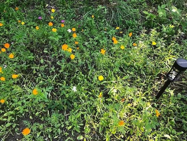
Unfortunately that process has already begun. It's inevitable. I'm going to try white clover and wildflowers in that area for next year. Everywhere else is pretty much mossed over. In the Spring I planted a patch of wildflowers in the back along the edge of the woods and they are doing pretty well.
-
77 / 62 the heat is on. Ridge building in to 594 DM with 850 MB temps spiking to >21C Mon - Wed. Partly cloudy 90 for the hotter spots today, otherwise upper 80s. Mid - upper 90s tomorrow, outside chance of century mark in the hottest spots. Only clouds / seasbreaze woudl hinder 100s in the hot spots inland Monday, with Tuesday the hottest day with widespread 100s . Wed a chance at the tri century if clouds / storms dont get in the way. T hu/ FRi deal with more storms as ridge wanes and we ride the periphery with storms and some stonger onshore. The weekend sees ridge re build with more heat in the 6/28 - 7/2 peeiod. Beyond there overall warm - hot / humid and wetter with storm chances. J uly 4th forecast to begin as in long range 336 hours forecast range. 6/21 - 6/25 : Hot - mainly dry heatwave 6/26 - 6/27 : Storms reduce or break heat 6/28 - 7/2 : heat builds back more 90s, storm chances 7/3 - Beyond : Warm - Hot, Humid overall - wettter storms
-
You really hate to see it and feel for these poor souls.
-
Remember when Ineedsnow said no big heat and meh and it was all staying to our SW? He said his hottest temp this summer would be 82 and he was forecasting with his long range Accuwx inside information.
-
This is what these trolls want. Some sick fucks. Good luck tracking the daylight loss on your calendar while your privates sweat off your body.
-
Holding onto losing daylight Because what’s more exciting in late June than the nostalgia of darkness at 4pm and breathlessly waiting for the Euro to show snowstorms in Pensacola and the GFS hammering us with perfect track rainers. The adrenaline rush of watching previously unmodeled scooter streaks blow apart a D5 blizzard. The overwhelming joy of watching lows deamplifying on guidance every 6 hours. Sorry, I forgot the daily 1.5” of upslope in Raccoon Rabies, Vermont. How wonderful.
-
I really don’t like even looking at winter at this point in time, that said, at this extremely early stage, I think we can assume a few things going into fall at least…. -PDO, -ENSO (either cold-neutral or weak La Niña; possibly a Modoki, central-based event?, -IOD, -PMM, +AMO, -QBO, still active sun; high solar/geomag, but descending from the solar max peak of last winter, *possible* average to below average Atlantic hurricane season; along with either average to below average ACE, very likely below to well below average arctic sea ice again. Other than that, I wouldn’t venture into guessing the possible oscillation (PNA, EPO, WPO, AO, NAO) states until we are into fall
-
-
We have months of heat and dews awaiting despite those holding on to losing daylight lol.
-
Count this down
-
Monday Sunny and hot, with a high near 104. Calm wind becoming northwest around 6 mph in the afternoon. Monday Night Mostly clear, with a low around 84. that’s the point and click for Baltimore
-
The summers really shifted to much warmer back in 2010. We haven’t had a single cool summer by long term averages since 2009. Our only below average summers for temperatures have been 2014, 2017, and 2023. And even those summers were slightly cooler only due to the rising 30 year means. They would have been pretty average summers for temperatures in past 30 year climate eras. So we have had a remarkable 12 out of the last 15 summers warmer to record warm. Plus the 70° and 75° dew point days have reached record levels also. From 2010 to 2013 we had a strong focus of 100° heat mostly in July. This was when the all-time summer high of 108° was set in several locations. But during the 2020s we have already seen local all-time highs for the month of June. This will be the 3rd year this decade with 100° heat in June. But July 2022 set the record for consecutive 100° day at 5 in Newark. So this coming record heatwave is following the same 2020s pattern of 100°+ heat in June. This reminds me of monsoon climates around the world which experience their greatest summer heat in June before the summer monsoon arrives. It will be something to monitor going forward. Since each June in the 2020s that reached 100° was followed by 10”+ rain in a few hours to days like last summer and 2021 at some later point.
-
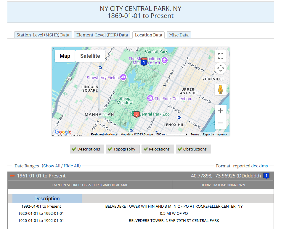
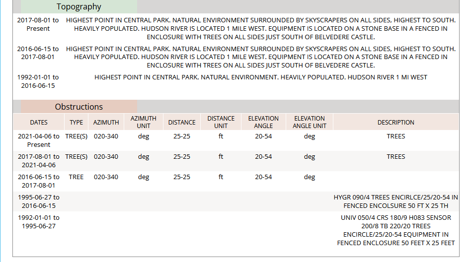
NOAA has noted the obstruction of the trees.

-
Our watch was upped to a warning at around 2AM starting 11AM Sunday. https://forecast.weather.gov/showsigwx.php?warnzone=MAZ004&warncounty=MAC027&firewxzone=MAZ004&local_place1=Hubbardston MA&product1=Extreme+Heat+Warning&lat=42.4804&lon=-71.993
- Today
-
Oh I just meant with sun and heat . I don’t think there’s any chance SNE sees the MCS. We don’t get those or anything exciting whatsoever . So just ruling it out
-
Extreme Heat Watch hoisted Hazardous Weather Conditions Heat Advisory in effect from June 22, 11:00 AM EDT until June 22, 08:00 PM EDT Extreme Heat Watch in effect from June 23, 11:00 AM EDT until June 24, 08:00 PM EDT
-
Tomorrow we start the countdown to December 21st, lose 3 minutes of daylight the next week
-
It's amazing what a difference low dewpoints make.
-
What an amazing evening last night. Needed to cut the grass before this scorching heat made it impossible to do. Nice cool breeze afterwards. 67 and sunny now.
-
I think even if NYC recorded a high of 75 you would somehow try to spin that shit as valid
-
Probably splits with Maine and NY/VT getting it.
-
The importance of an offshore wind at JFK cannot be overstated. The ultimate June example: June 27, 1966 highs: Central Park: 101; JFK Airport: 82.
-
West is best Sunday