
All Activity
- Past hour
-
At least the smoke is at higher altitudes today than close to the surface back in 2023. It will be interesting to see if it can prevent the 100°+ that was forecast for tomorrow at the usual warm spots across the region. These HRRR smoke plume forecasts seem to shift from run to run.
-
 Well before my time, so I don't know. But Canadians have dual-pol as well, so TDSs are possible to observe. I'm pretty sure I've seen a couple outside my forecast area.
 -

2026-2027 Super El Nino
snowman19 replied to Stormchaserchuck1's topic in Weather Forecasting and Discussion
All one has to do is look at these current anomalies and sea surface heights/thermocline and there should be no question that this is going to be an all-time historic Nino event -
92/78.
-
 All the hail that has fallen on our yard in 28 years (going on 29) would fit in a 2-pound coffee can. I was sad to have missed the 2007 storm, but happy that I still had a garden.
 -
 Yeah ...ensembles means are not likely to be as deep as operational versions at this range. It's just logic. If you have a pool of members, there's apt to be some that are always less - that weighting skews the mean... duh. So when the operational are that deep, the ensembles look like this, below - which is consistent with their summer +PNA during that time range. Which is still cold for warm enthusiasts unfortunately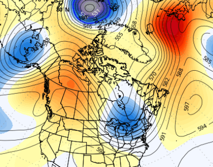
-
 Having the Doppler radars now in Canada really helps for NNE radar coverage, esp. since CXX is practically useless ern semicircle. It still amazes me that the NWS was not allowed to put the CXX radar on a mountain top when it was installed in the late 90s. This action thumbs its nose at protection of lives and property, and should override anything else in this case. Was that due to VT State Regulations about towers on mountain tops? It wasn't always that way, right? Mt Mansfield has communication towers.
 -
Correct me if i'm wrong, but wouldn't this be like "block out the sun for a few hours" kind of stuff in Michigan?
-
Wow, great reports! "Leaf salad," LOL. It is amazing how efficient large hail is shreding trees very quickly!
-
 Ya its nasty looking.. tomorrow doesnt look any better now.. NWS Boston @NWSBoston · 10m Another plume of wildfire smoke is likely to shift southward into the region in larger concentrations Weds, some of it detectable at the surface. This will again limit temperatures while also bringing hazy skies and a hint of a smoky smell in the air tomorrow.
 -
I wouldn't be surprised if we get severe elevated hail overnight given those morning soundings to our west. Plenty of support for that.
-
We'll see. We have yet to really see an uptick in TDS/tornado verification in our area. And our radar is well sited to capture stuff to our northwest. Now if it's some moose fart north of the mountains our radar won't see that lofted debris anyway. We do catch "lost" tornadoes sometimes with satellite passes. Like sometime after 2017 a tornado track appeared in the Pemi Wilderness. No idea when it happened, but it's there.
-
That event caused near-total defoliation of the trees along Rt 302 in Naples, and probably elsewhere that I didn't view. The only other significant defoliating storm was 5-10 miles SE from home, in Rome and New Sharon, on August 30, 2007. Next morning I found 1-2 miles on Rt 27 on the Rome end of Mile Hill as a 2-track thru 6" of leaf salad. Folks there reported up to 4" deep hail in places away from where water flow gathered the ice. Perhaps 2,000 acres were stripped and when the Maine Forest Service forester examined things there, she found considerable debarking, especially in Aspen. Some stripped hemlock did, pines refoliated in the spring, and ash became like bottle-brushes as scores of lateral buds sprouted. Some 2" chunks were reported but along Rt 27 I found only dimes/nickels/few quarters (at 5 PM 24 hours after the storm).
-
 HRRR tries to bring New Hampshire into the game overnight.
 -
Yes to downsloping.
-
Still waiting on the real show around 22z though.
-

July 2026 General Discussion
TheClimateChanger replied to Chicago Storm's topic in Lakes/Ohio Valley
Looks legit by the way, maybe a tad warm. Checked PWS stations around there and most were in the 100-103F range, even right to the shore. -
 Not their ensembles
 -
 The NWS removed the 30% for thunderstorms late tonight or tomorrow locally so that kinda sucks
 -
July 2026 General Discussion
TheClimateChanger replied to Chicago Storm's topic in Lakes/Ohio Valley
Wow! 104F now. Really mixing well there - downsloping effects? Dews are cratering with gusty west winds. -
July 2026 General Discussion
TheClimateChanger replied to Chicago Storm's topic in Lakes/Ohio Valley
Up to 102F at Oscoda, Michigan. Toronto, Ont. was up to 97F at the top of the hour. -
WxWiz will do his best to apply "english" to the risk areas to nudge them closer to CT!
-
The smoke has moved here. Sun tried and failed to work about noon, and by 1:30 we had that same dingy yellow/brown that dendrite posted. The only thicker smoke I can recall was when I was working at a forest fire. No 90s here; possibly not even 80s.
-
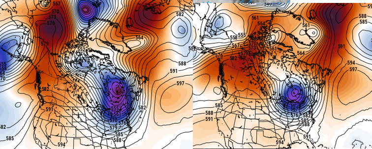
12z Euro/GFS both pushing the bounds of credibility with that (apparently) unconstrained trough depth around the 21s/22nd ... The indexes have an unusually amplified +PNA numerically signaled in that time range, so some sort of anomaly is okay but ... egads! doesn't have to -3.5 SD, either. I guess in order to balance the hemisphere for all that French rage the models have to hang their asses over somewhere to make the world fair.. lol
-
The watch now would not be for the big stuff later I think. Marginal svr is psbl this aftn in cntrl/nrn ME. The tor box would be later for far nrn VT/NH, and NW ME.







