All Activity
- Past hour
-
It’s a very interesting setup. Still very unclear what’ll happen.
-

September 2025 OBS-Discussion centered NYC subforum
doncat replied to wdrag's topic in New York City Metro
0.17" here, was expecting more like 1.50"... Been keeping records for nearly 50 years, have never seen a pattern like this which has been going on for a year now . -
I updated the map. There are more members with heavier rain!
-
Watch the long range though. Remnants get picked up by a trough eventually.
-
Showed up again at 18z and especially at 00z. Again, fantasy range and speculative but maybe worth watching as the ridge breaks down and a trough scoops up whatever remnants there are. Humberto is and was always gone.
-
.thumb.jpg.6a4895b2a43f87359e4e7d04a6fa0d14.jpg)
Central PA Banter (Banter Less?) Thread
Yardstickgozinya replied to Itstrainingtime's topic in Upstate New York/Pennsylvania
I'm really looking forward to Sunday. I've been dreaming a lot lately about Barbers Interception, return in the 2002 championship game. I'm more than ready to see Eagle fans cry and go poo poo again. The city and fans have only got a whole lot smellier since 2002. I would have been an eagles fan, but at a young age I got tired of having to smell the city and the Eagles, Schuylkill river bathing fans. -
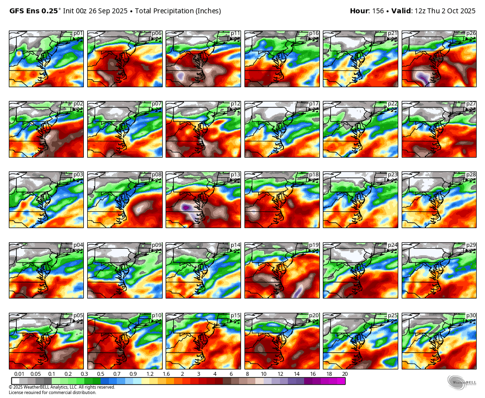
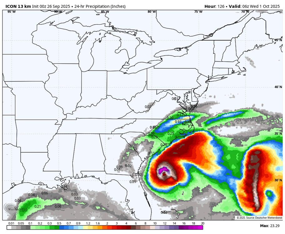
WB 0Z GEFS still lot of uncertainty on Imelda to be location and intensity. There are a few members that bring heavy rain to DMV.(some of the rain shown is from the weekend)
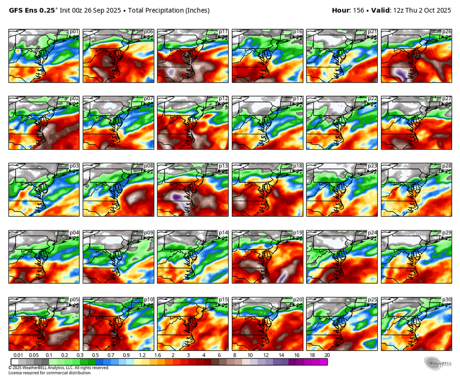
-
Tomorrow (today technically) looks like the best weather day. Gonna be humid.
-
 We have seen tropical storms go from nothing to a cat 4 in a day lately under the right conditions. I would not be surprised.
 -
Yeah that didn't count, just a few hundredths.
-
0Z Can is also a miss. Rain does not even get to Norfolk....
-
What a ridge on the GFS
-

Invest 94L—80% 2 day and 90% seven day odds of development
RU848789 replied to WxWatcher007's topic in Tropical Headquarters
borders? Tabloid would be a step up for that rag. -
This pattern reeks of surprises and changes to come in the models. So many moving parts but the big high over the top gives opportunities
- Today
-

September 2025 OBS-Discussion centered NYC subforum
winterwx21 replied to wdrag's topic in New York City Metro
All the humidity this week and we couldn't even get a quarter inch of rain out of it. Frustrating. I'm sure the moderate drought will be expanding across the area over the next couple weeks. Hopefully it won't get as bad as it was last fall. -
The timing of that meant I relied on it so much for it to cancel at least one day of school and the weekend/week aftereffects where it fell apart was probably my worst week of high school. God, the fact that it just went the wrong way for 8 runs in a row when I just needed 2 inches was devastating.
-
Seattle is now 3-1 with Mike MacDonald as HC.. they were 10-7 last year with Geno Smith QB. Baltimore may have missed an opportunity when they didn't upgrade him to HC after the defense was #1, 2 years ago.
-
Looks like a nascent eye was trying to develop as of a few hours ago.
-
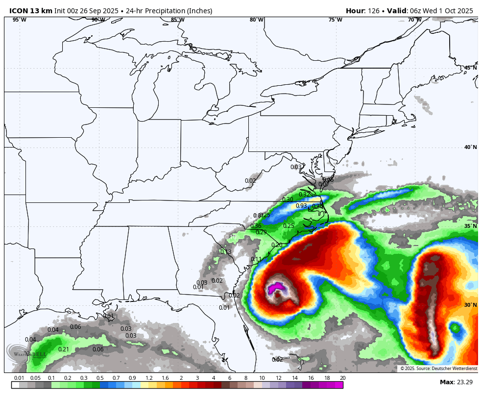
WB OZ ICON has Imelda Jo be approach SC coast but then spins out to sea. Rain only makes it into SE VA.
-

September 2025 OBS-Discussion centered NYC subforum
LibertyBell replied to wdrag's topic in New York City Metro
on air mets said the *improvements* happened because we got more sunshine than expected this afternoon lol -
September 2025 OBS-Discussion centered NYC subforum
LibertyBell replied to wdrag's topic in New York City Metro
we had mostly sunny skies for awhile really nice -
September 2025 OBS-Discussion centered NYC subforum
LibertyBell replied to wdrag's topic in New York City Metro
we're also due for a 1983 like summer where you can be 95-100 from June through September -
 Speculative at this point but I think anything from a TS to C3 are possible. I agree with the odds of a 4 being very low. I've said this elsewhere but we have to remember that major hurricane strikes along the east coast are actually pretty rare. Since 1990 there have only been three. Andrew '92, Fran '96, and Jeanne '04. Here, there's a window where this will likely intensify, but near the coast future Imelda may have to deal with the effects of southerly shear and dry air being imparted into the circulation. Along with cooler temperatures near the coast. That said, the Euro has intensification near landfall, probably because there should be a strong outflow channel to the north. Right now there is a robust mid-level circulation apparent on satellite. We really need to see how that translates as it reaches the high SST/OHC environment near the Bahamas tomorrow. Given its current appearance and how Humberto was able to more quickly develop and intensify in its environment, I do think it's on the board that this has an impressive appearance tomorrow if shear relents some.
 -
September 2025 OBS-Discussion centered NYC subforum
LibertyBell replied to wdrag's topic in New York City Metro
Yep, we have to make our own forecasts now, the way they used to do it -
 ET phone home?