All Activity
- Past hour
-
63 / 55 - warmest day since May 17th or May 2nd for many. Mid - upper 80s, stray chance one of the hot spots in C/NE/N-NJ could touch 90. Some haze / smoke could reduce a degree. Tomorrow first 90s for many in NJ / NJ/NYC metro areas and some of the boroughs. Friday would get there too but clouds and scattered showers / storms look likely. Another cloudy weekend with storms and showers, although the latest forecasts have less focus of rain still think 1 inch is likely. Sunday could clear later in the day but other data has gone to the slower frontal passage the ECM has had most week, cloudy but warmer than the last 2 weekends. Next week 6/9 - 6/13 - near / above normal still rain chances with trough west of us into the GL/MW. Overall warmer look - wetter look into mid month. Heights rise later and pieces of the western heat building over the top and expanding east. GFS continues to try and get some tropical activity in the Gulf. Next shot at 90 degree temps would be in the 6/14-6/17 range.
-
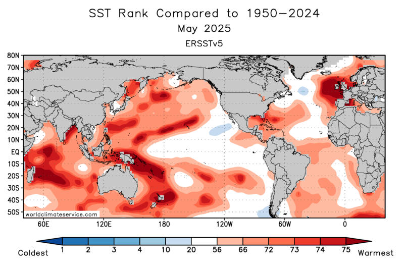
My guess is that the duration of this current -PDO interval, which emerged around 18-19, will linger as long as the WPAC stays this warm. May had multiple areas west of the Dateline ranking near the warmest on record. We probably would have continued the +PDO which emerged around 13-14 right into the 2020s if it wasn’t for that rapid increase in WPAC 500mb heights which warmed the WPAC leading to the -PDO. Hopefully, the changes in the WPAC at 500mb and the surface don’t permanently load the dice for more -PDOs with only intermittent +PDOs. In the old days, the -PDO defined more by the cold pool off the West Coast. Now, the warm pool and 2nd EOF of the PDO in the WPAC are running the show. It would be nice to get monthly real time 2nd EOF updates. But the the ranking charts below can be used in place of the formal 2nd EOF numbers. 2014 to 2018 +PDO 2019 to present -PDO

-
no shit... how much is smoking claiming temps - ooh!
-

-
lol what clowns we are. Whatever it’s Wednesday and weather is boring as hell.
-
One of his better songs . Thanks for clarifying your error
-
You think it’s a fucking game??
-
yeah, was asking about this yesterday .. with the HRRR stuff etc ... So far we're ahead of yesterday in T recovery by 4 ( 64 vs 60) by hour::minute. We didn't bottom out quite as deep. 54 here. I realize others came in at or just under 50 but by and large these readings were above the previous night's lows. The higher launch may be skewing/hiding if there is any smoke-induced lag so hard to quantify -
-
He was still listening to RUN DIT in the 90s
-
He fail
-
Still some smoke but bluer sky than yesterday
-
Wrong song. What’s my name
-
Yeah, NJ has done a good job of keeping the heat during the 2020s. The enhanced onshore flow has lead to quite a 90° gradient. The last 5 seasons have averaged 41 days reaching 90 west of the sea breeze front in NJ. Here along the CT Shore we have only been around 12 days. Monthly Number of Days Max Temperature >= 90 for HIGHTSTOWN 2 W, NJ Click column heading to sort ascending, click again to sort descending. Mean 0 1 6 19 12 2 0 41 2024 1 1 11 17 11 0 0 41 2023 0 0 2 18 5 6 0 31 2022 0 3 3 22 19 2 0 49 2021 0 3 10 14 13 1 0 41 2020 0 0 5 23 13 1 0 42 Monthly Number of Days Max Temperature >= 90 for NEW HAVEN TWEED AP, CT Click column heading to sort ascending, click again to sort descending. Mean 0 0 2 5 4 1 0 12 2024 0 0 2 3 4 0 0 9 2023 0 0 0 4 0 4 0 8 2022 0 1 1 6 9 0 0 17 2021 0 0 4 3 5 0 0 12 2020 0 0 1 7 4 0 0 12
-
God, I love June weather dialogue....
-
It’s not one of his better ones.
-
I wish we could get a stretch like New England had in 1780 with the Dark Day
-
I wonder how many people know that song lol.
-
You think it’s gonna rain??? You think it’s gonna fucking rain??? Come on…..
-
Another 0.60" overnight brings the total up to 1.80". Still quite a few people in the IL portion of the QC without power early this morning.
-
D-I-T You want him we got him come and get him he weenie getting weather facts from twitter baby
-
50 was the low here.
-
If the smoke is the cause of the ozone wouldn't that make the ozone in our case elevated?
-

2025 Atlantic Hurricane Season
LongBeachSurfFreak replied to BarryStantonGBP's topic in Tropical Headquarters
Unfortunately Florida would be my favored area for another Major. It’s only a matter of time before we see another Andrew into south Florida. I would never favor the NE for a hit as it’s a low probability year over year but it’s the most “due”. Water temps in the home grown area for the north east are the most anomalous in the entire basin. A Bob or Carol track would almost certainly lead to a major hit for eastern New England. Something that hasn’t happened since 1938. Obviously no one will feel sorry if the Hamptons are destroyed. Having spent time out there, there are middle to lower income communities were workers live. And these people would be the most impacted.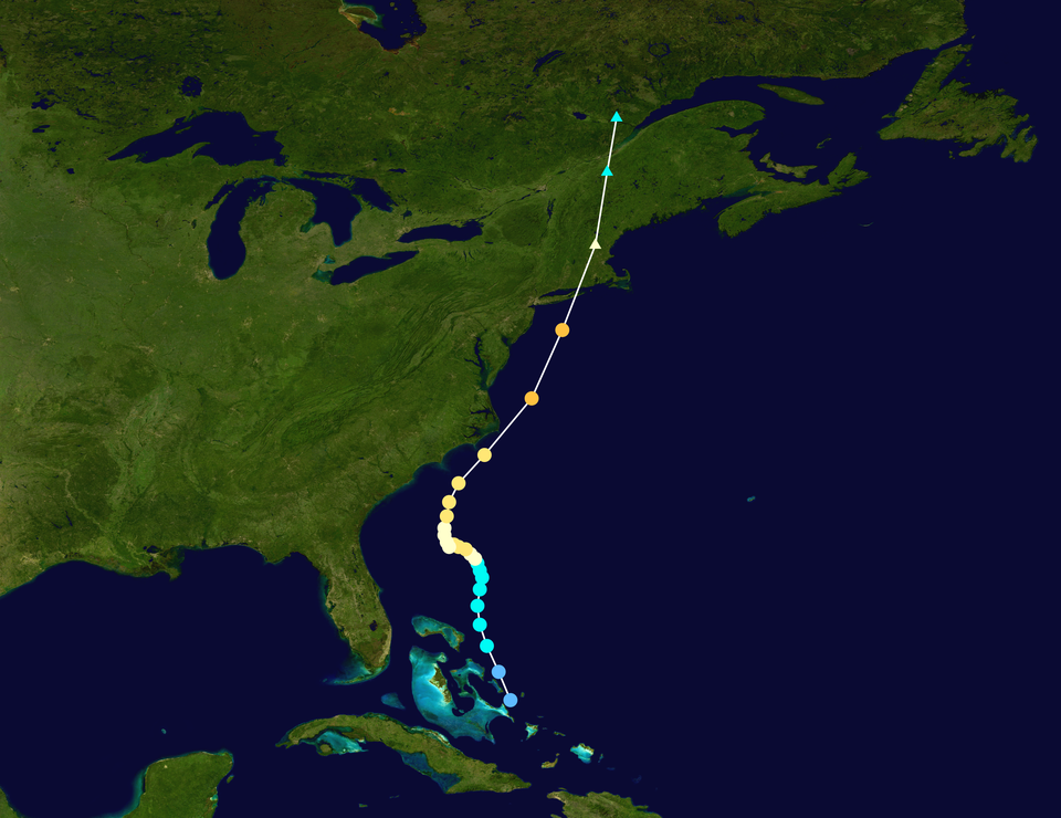
-
I think this diagram answers my own question. It seems wildfires can contribute to ozone formation?
- Today
-
Very good point. I heard the same in the car this morning driving to work. I heard the air quality alert and assumed it was for the smoke. Then he said it was for ozone and I'm like what?


