All Activity
- Past hour
-
Looks to me like the GFS and CMC at 12z are quicker w/ the energy over the GL. The Euro slows it down and drops it into the backside of the trough. That might be an error by that model as it tends to hold energy back. I'd feel better if the GFS had it. I need to check the ensembles. But...if that were legit, that is a lot of energy to crank to our SE. The sigma maps on Weatherbell are impressive at 500.
-
Not many other models are showing this much development, but man....that will leave a mark. Partial phase, but doesn't get neutral in time for us. There are some nice upslope snows for those in the best spots.
-
 lock it in.
 -

Overnight Wednesday, November 5, 2025 Wind Event
CoastalWx replied to weatherwiz's topic in New England
I know but things like orientation of the low when the LLJ swings by matter. 50-55 at 925 vs 65kts is bigly difference. Hopefully 00z is damaging. -

Best Mid-Atlantic winter storm of the last 40 years
PrinceFrederickWx replied to PrinceFrederickWx's topic in Mid Atlantic
‘96 and Snowmageddon 1 were tied before I bumped this. Now Snowmageddon 1’s taken the lead. -
We really need to start looking at a way to archive these threads and save them as an online library. It would be a huge loss to lose these. This forum is probably the best library of weather events dating back to 2014 for the Tenn Valley.
-
Seems the EPS/GEFS today may have killed it more too. I'm not sure if that is why today we've seen a trend towards less ridging in the E after D10 somewhat. A less potent run through 6 late and 7 might result in that.
-
Fountain, if you go to the Oct 24th or 25th(2014 thread above) post by @tnweathernut, there is some good discussion by John, 1234, and tnweathernut. I have no idea what I was doing during that timeframe! I didn't post until a bit closer to the event which is unusual. Anyway, 1234 posted some maps of the event from about a week out. That was a fun one to track. Pretty sure there was snow in the Williams-Bryce Stadium stands in Columbia, SC, for that game.
-

November 2025 general discussions and probable topic derailings ...
vortex95 replied to Typhoon Tip's topic in New England
I'm not advocating the bad impacts, just pointing out the meteorology of the event and its potential. Pattern recognition plays a big role in this case. -
 Hopefully this over performs and see hundreds of thousands outages and trees down. You should post this in the thread for it
 -
JFC my social media feed is filled of the most blatant not even mildly clever or “we don’t actually mean it that way” overt disgusting anti Muslim bigotry over the NYC mayor race. And it’s not just randos. Congressman. News anchors. Fucking Fortune 500 CEOs posting stuff that would get me fired! And no one is saying anything. WTF is going on. When did I miss the “we can just be bigots and not even pretend anymore” memo?
-
Here are our threads: Tennessee fans had trouble getting to the game in South Carolina. This was part of a string of early season snows around that time frame. Pretty sure we were the bullseye, and it shifts SE. There are some good maps and discussion in our threads. The Capitol Weather Gang has some maps as well. Indeed, there are some photos of Erwin in our observations thread. Crazy storm.
-
Sorry I made my position clear. I can live with what I’m doing. Do what you think is right.
-
November 2025 general discussions and probable topic derailings ...
vortex95 replied to Typhoon Tip's topic in New England
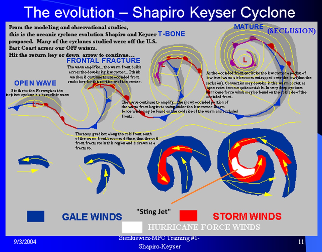
The late Wed/early Thu event looks very impressive. Low pressure 998 mb over Lake Huron noon EST Wed, and rapidly deepens to 979 mb just E of EPM by 6am EST Thu. Interesting and unexpected things can happen in such a case. W/ most low pressures that RI, there is often a "sweet spot" location that takes full advantage of this RI, meaning you can get absolutely crushed above expectations. The way the pattern is currently, New England is in this sweet spot. So wild precip and wind is possible. Perhaps the most impressive example of this was the Bliz of '78. The mean trough position has been very good for the E Coast events for over a month now. Best lead into winter for a pattern I have seen in some time. One thing about these kind of situations, the "surprise factor" is higher than typical. Given the mean trough position is excellent for the NEUS (we saw what happened last night -- overperfomed), why not? When its "good," it can be *really* "good." meaning sometimes you can get in to patterns that are relentless, everything goes right, and so nuts that even CoastalWx will forget his pain from the lack of snow he dealt w/ in the 80s (no 4-8" backlash, instead sunny when he got up in the morning), and the pitiful winters in the 2020s so far! Jan-Feb 2015 was such one period. Entire winters like 1992-93 and 1995-96 were like this. CoastalWx also needs to keep in mind Dec 9, 2005 in mind when it comes to wind w/ these type of storms. Sting jet! He'll be looking for the PVU anomaly and tropospheric fold I bet. LOL.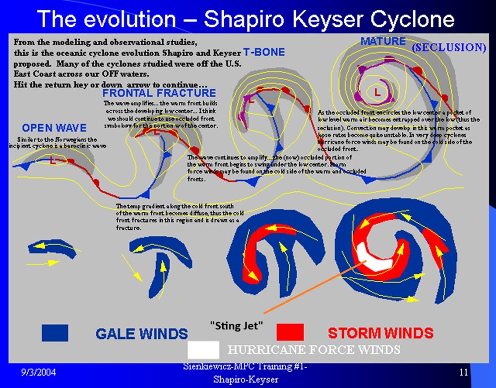
-
I’ve got plenty of other shit going on my life than your principled stand in a weather forum. If you want to leave, stop posting.
-
 Not looking forward to this. Veterans Day Mostly sunny, with a high near 43.
 -
I made my choice. Do what you have to do. The weather doesn’t mean that much to me compared to what’s going on.
-
Can we not do this martyr thing again?
-
https://www.washingtonpost.com/news/capital-weather-gang/wp/2014/11/01/incredible-early-season-snow-slams-the-southeast-impacts-felt-across-eastern-u-s/
-
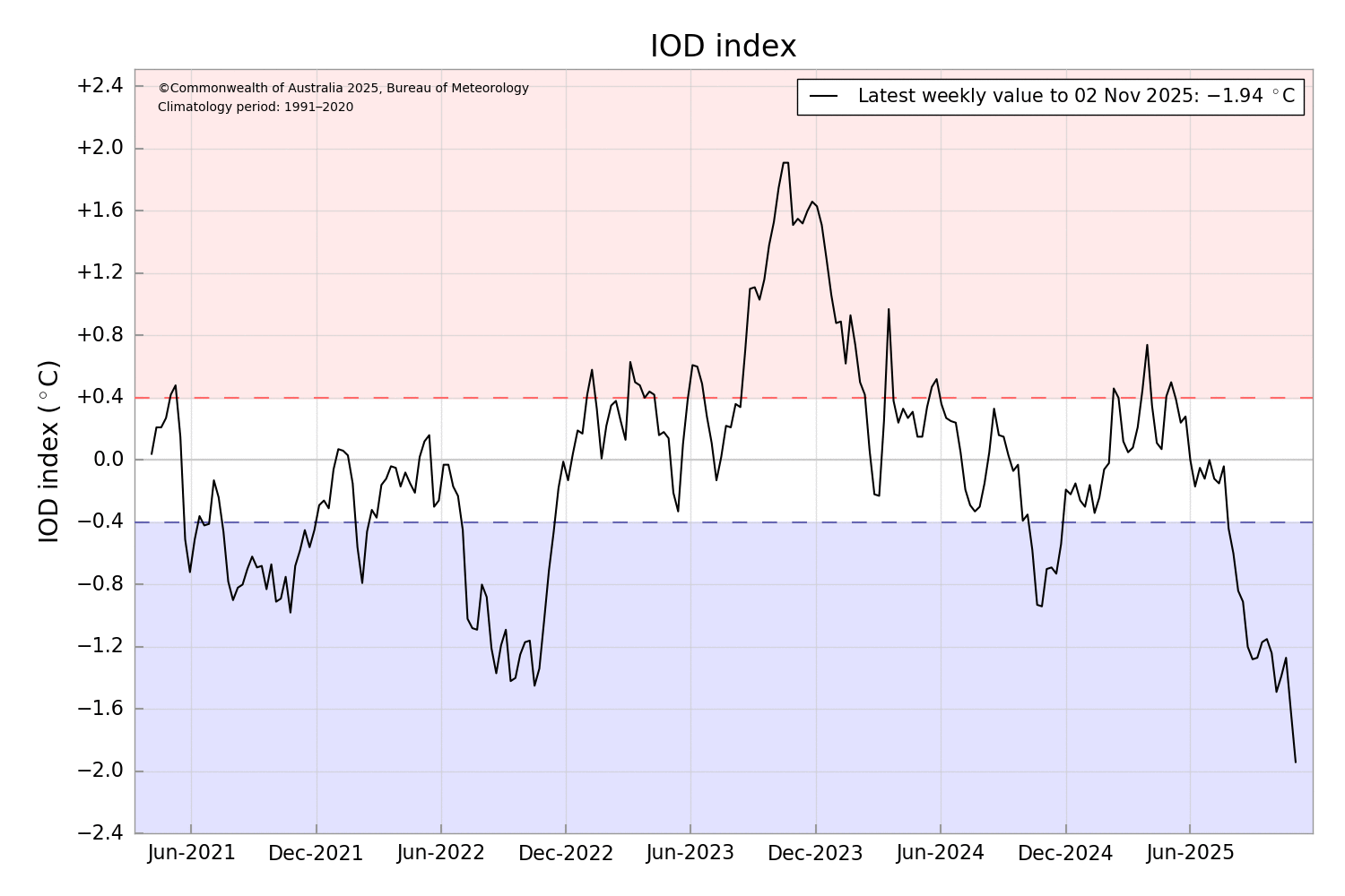
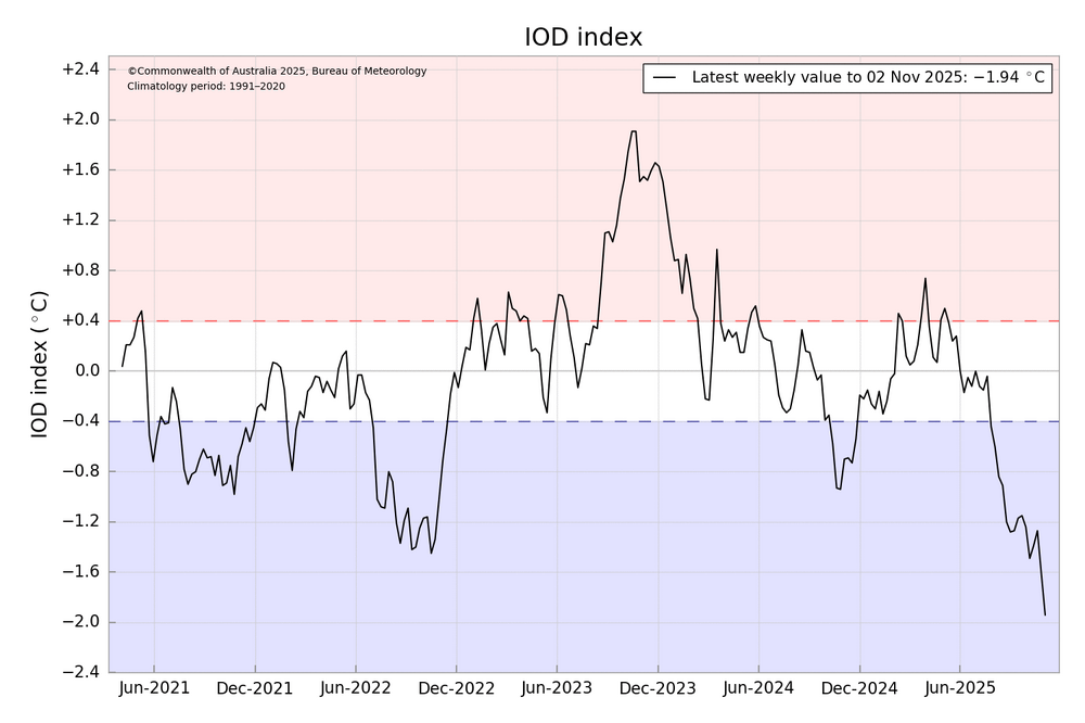
The last big -IOD and rebound a few months later actually enhanced the storm track pattern back in late 2022 rather than changing it.
-
I forget which winter it was recently, I’m sure you remember, but the models kept incorrectly showing high amplitude MJO waves barreling right through phases 8-1-2 over and over all winter long (EPS in particular), in the long-range which never actually happened. They also kept showing phantom SSWEs and record weakening of the SPV, which also never happened. It was brutal, everyone kept falling for it….
-
Sorry you’re gonna have to ban me. Permanently. I’m on my hill and I’m willing to die on it.
-
Ok that’s all of that
-
 37. My sensor is only 20' from the water so it won't reflect what's actually happening.
 -
Yes, I was using it for another thermometer, but that one doesn't have an app, so it was annoying. The sensor/device is the size of like a dry erase board eraser.