All Activity
- Past hour
-
 @dmillz25 @Stormchaserchuck1 @Rjay
 -

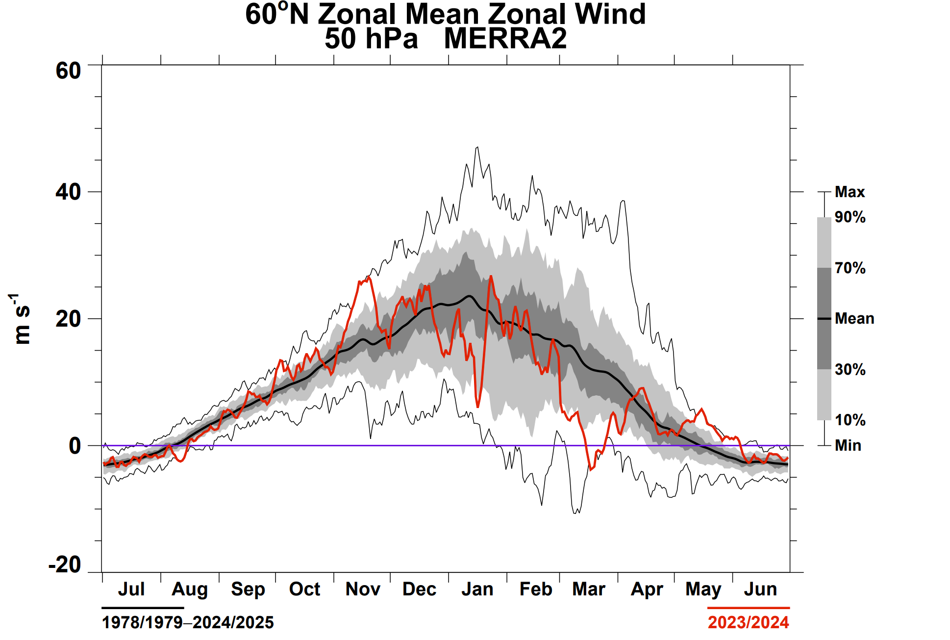
2026-2027 Strong El Nino
michsnowfreak replied to Stormchaserchuck1's topic in Weather Forecasting and Discussion
January 2024 actually was a decent winter month here. It was shockingly (for a strong nino) the wettest january on record at Detroit. Which jives with what you mentioned about strong ninos being wetter. There was a big cold snap mid month and the Plains actually finished the month colder than avg. It was the warm and very low snow December and February that made it such a bummer winter. PRELIMINARY LOCAL CLIMATOLOGICAL DATA (WS FORM: F-6) STATION: DETROIT MI MONTH: JANUARY YEAR: 2024 LATITUDE: 42 13 N LONGITUDE: 83 20 W TEMPERATURE IN F: :PCPN: SNOW: WIND :SUNSHINE: SKY :PK WND ================================================================================ 1 2 3 4 5 6A 6B 7 8 9 10 11 12 13 14 15 16 17 18 12Z AVG MX 2MIN DY MAX MIN AVG DEP HDD CDD WTR SNW DPTH SPD SPD DIR MIN PSBL S-S WX SPD DR ================================================================================ 1 36 31 34 6 31 0 T T 0 9.2 18 20 M M 10 1 27 20 2 33 30 32 5 33 0 0.00 0.0 0 14.0 22 260 M M 10 28 260 3 35 32 34 7 31 0 0.04 0.2 0 8.9 17 360 M M 10 16 24 350 4 32 19 26 -1 39 0 T T T 8.0 18 360 M M 7 25 350 5 32 19 26 -1 39 0 0.00 0.0 0 6.1 14 210 M M 9 17 200 6 37 28 33 6 32 0 0.03 0.2 0 6.9 13 70 M M 10 1 19 70 7 36 30 33 7 32 0 0.06 0.6 T 5.6 13 290 M M 10 1 18 290 8 36 32 34 8 31 0 0.00 0.0 0 7.3 13 160 M M 10 18 18 170 9 44 33 39 13 26 0 0.86 T 0 12.1 33 230 M M 10 1 43 230 10 40 33 37 11 28 0 0.01 T T 16.1 31 240 M M 10 1 41 240 11 37 31 34 8 31 0 0.09 1.5 1 10.3 21 230 M M 10 18 26 240 12 38 30 34 8 31 0 1.04 4.6 0 11.2 29 220 M M 10 128 37 240 13 37 17 27 1 38 0 0.04 0.9 3 24.3 38 230 M M 10 19 52 230 14 17 -2 8 -18 57 0 0.02 0.6 4 20.8 30 240 M M 7 89 39 240 15 9 -3 3 -23 62 0 0.00 0.0 4 12.4 17 230 M M 6 22 230 16 12 3 8 -17 57 0 0.03 0.6 4 14.7 22 240 M M 7 1 28 230 17 18 2 10 -15 55 0 T T 4 17.0 28 230 M M 7 35 230 18 25 18 22 -3 43 0 0.12 2.5 5 8.2 15 220 M M 10 1 20 230 19 23 8 16 -9 49 0 0.11 2.0 6 8.8 21 10 M M 8 19 28 10 20 19 2 11 -14 54 0 T T 7 8.7 22 320 M M 5 29 330 21 25 7 16 -9 49 0 0.01 0.1 6 9.1 22 220 M M 6 27 230 22 33 9 21 -4 44 0 0.05 T 6 11.6 21 220 M M 9 146 26 230 23 34 32 33 8 32 0 0.45 T 5 3.9 9 150 M M 10 126 14 120 24 39 33 36 11 29 0 0.35 0.0 4 1.8 9 40 M M 10 12 11 40 25 40 36 38 13 27 0 0.17 0.0 2 5.8 14 50 M M 10 12 21 40 26 41 32 37 12 28 0 1.07 0.0 T 4.9 16 30 M M 10 12 25 30 27 41 35 38 13 27 0 0.01 0.0 T 4.6 13 40 M M 10 18 18 50 28 39 33 36 11 29 0 0.41 0.8 0 12.4 22 20 M M 10 1 32 20 29 37 32 35 10 30 0 T T 0 8.6 20 200 M M 10 23 200 30 34 31 33 8 32 0 0.28 2.4 0 7.3 17 200 M M 10 12 24 220 31 39 33 36 11 29 0 0.00 0.0 2 8.4 23 230 M M 10 1 30 240 ================================================================================ SM 998 706 1155 0 5.25 17.0 309.0 -

E PA/NJ/DE Spring 2026 Obs/Discussion
KamuSnow replied to PhiEaglesfan712's topic in Philadelphia Region
We have a shagbark hickory tree that is kind of half leafing out, the other half not so much. It's unusual enough to concern me. The 1st noticeable casualty was a wisteria that was leafing out and had flowers, and it got fried. All the leaves are brown (and the sky is gray) and falling off. Hoping for full recovery! -
2026-2027 Strong El Nino
michsnowfreak replied to Stormchaserchuck1's topic in Weather Forecasting and Discussion
Thats the way to run a strong nino. Cansips has been hellbent on a 3rd straight cold winter in the Great Lakes. -
much rather cad than coast
-

Central PA Spring 2026 Discussion/Obs Thread
Blizzard of 93 replied to Voyager's topic in Upstate New York/Pennsylvania
Let’s go Sixers! Great team effort! -
The NW flow will have to let up which is just starting...
-

E PA/NJ/DE Spring 2026 Obs/Discussion
Chief83 replied to PhiEaglesfan712's topic in Philadelphia Region
Been reading the issue of the late cold snap having negative effects on the fruit trees and vineyards and wonder if anyone else has concerns about the lack of new leaves on some of the trees. We have several well established older trees that I'm pretty sure startled showing new green leaves a few weeks ago. Now all that new growth ( it was pretty limited) appears to be dead and no new green is seen. Did the new growth freeze?. It could be these trees are a variety of naturally late getting leaves, but now it is May and they look like a leafless January tree. I don't think they are dead, but I do wonder if or when they will show signs of life. As I drive around I see other trees in the same condition. -
April ends about avg. temp wise here but definitely pretty dry. Picked up 0.39 today, which is the most daily precip we've had all month. Looking forward to some active weather coming up.
-
Models went way south for a lot of NC. Next.
-
2026-2027 Strong El Nino
so_whats_happening replied to Stormchaserchuck1's topic in Weather Forecasting and Discussion
That is why it is important for the 500mb to react in the proper manner so things do actually connect. Just because a precursor occurs to create this Strat warming/+GPH pattern but nothing actually sticks at 500mb than you just get warming aloft and nothing connecting. In my mind 23-24 had all the right things going for it but the 500mb atmospheric pattern was flat out wonky given the upper atmospheric pattern taking shape. -

2026-2027 Strong El Nino
Stormchaserchuck1 replied to Stormchaserchuck1's topic in Weather Forecasting and Discussion
They must calculate in different areas.. Dec 2025 had a >+300dm anomaly which is extreme, only rivaling years like Dec 2021 so the exact coordinates of calculation makes a big difference in the reading since the ridge/block was "on the edge". -
Fire that damn bus up.
-

2026-2027 Strong El Nino
GaWx replied to Stormchaserchuck1's topic in Weather Forecasting and Discussion
Monthly “WP” table has this for D, J, and F 2025-6: 2025 Dec 0.08 2026 Jan 0.07 Feb 0.23 https://psl.noaa.gov/data/correlation/wp.data Daily WPO has one of the most negative WPO Decembers on record with every day <0. There’s no way that a monthly of +0.08 has anything to do with the actual WPOs of Dec 2025. It looks like a major malfunction: https://downloads.psl.noaa.gov/Public/map/teleconnections/wpo.reanalysis.t10trunc.1948-present.txt -
2026-2027 Strong El Nino
so_whats_happening replied to Stormchaserchuck1's topic in Weather Forecasting and Discussion
This is why it is important to get a solid Wave 2 attack on the SPV like we would typically like to see for that winter potential is you need to have the pacific pattern also in conjunction with the developing -NAO. As I see above the talk about the NAO and the lack there of, at least with consistency, is a huge factor in just continuing with the large scale wave 1 patterns attacking the SPV. The 500mb pattern is important in that regard not necessarily the overall warming/+GPH that takes place in the Strat.
-
2026-2027 Strong El Nino
Stormchaserchuck1 replied to Stormchaserchuck1's topic in Weather Forecasting and Discussion
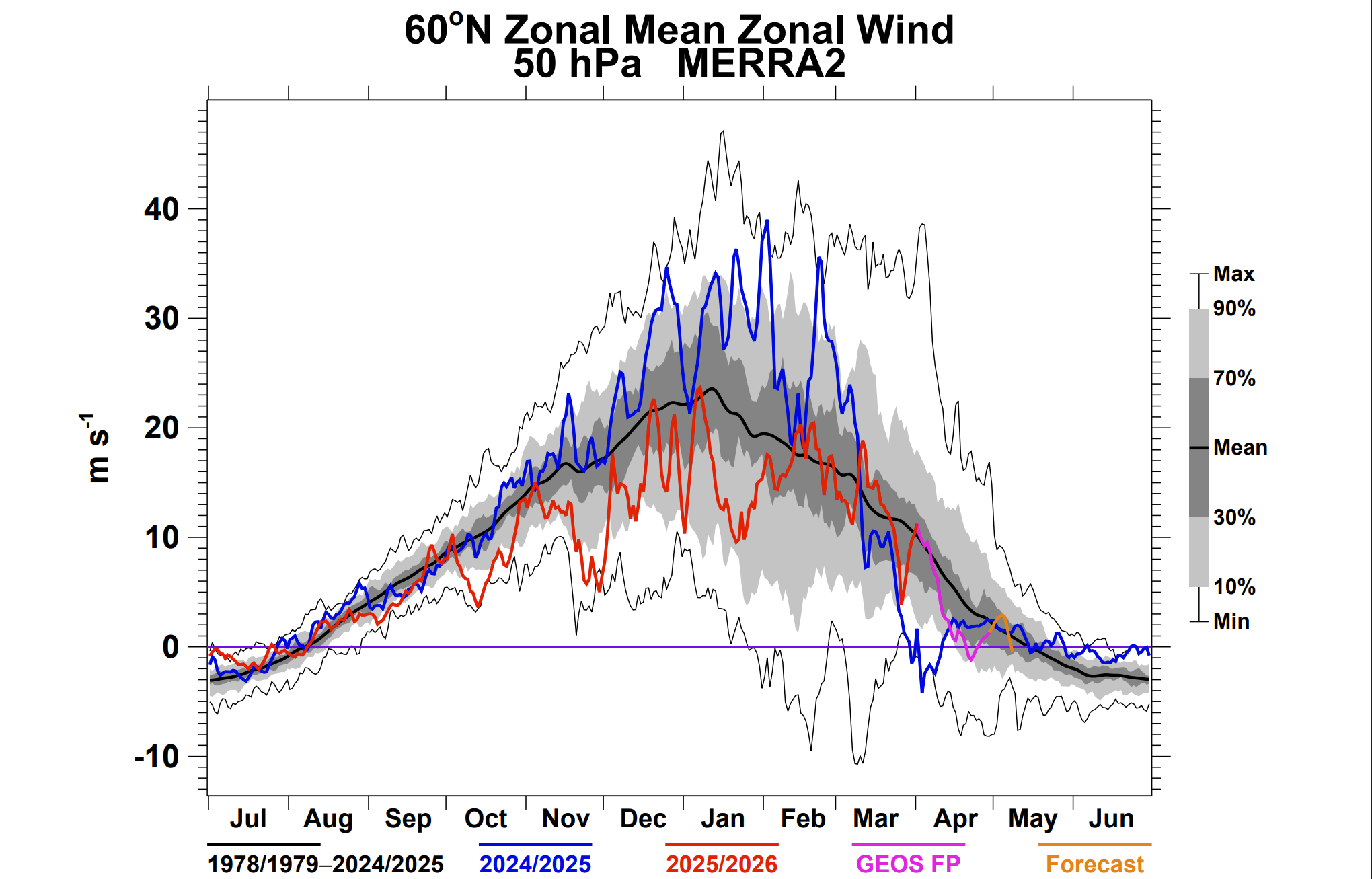
23-24 wasn't always connecting with 50mb as there was some disconnect between the upper and lower atmosphere but the mean for the Winter was pretty warm at 10mb Nov didn't have the warming like 2025 -
2026-2027 Strong El Nino
so_whats_happening replied to Stormchaserchuck1's topic in Weather Forecasting and Discussion
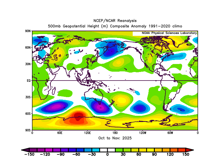
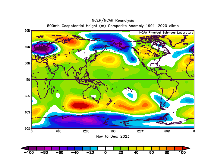
It did not the SPV was stronger to start than this past year but had a very similar large wave 1 like this past year about a month apart from each other. 25-26 November while 23-24 had it in December. Look at the difference leading into both SSW events at 500mb. 23-24 had an atmospheric pattern at 500mb not conducive to sustain the ridging like we would want to see. 25-26 set it up and finally connected in the Nov-Dec 500mb pattern which is exactly what we would want to see occur. Both had very similar Stratospheric ridging patterns but very different 500mb patterns existed thus leading to different results. Both years were in deeply negative PDO territory rising as we got to winter, this past year was some lowest numbers recorded. Both years had a -QBO state at 30mb and were descending (2023 was a tad bit later but still negative during these times). You could make the argument that this past year had more of an El Nino kick to the atmosphere than the year where we had a strong/super Nino.
-
2026-2027 Strong El Nino
Stormchaserchuck1 replied to Stormchaserchuck1's topic in Weather Forecasting and Discussion
January 2024 had a -NAO and some cold. The -NAO kept linking up with SE ridge 2018- March 2023, then in Jan 2024 it started to occur with more of an East coast trough, and the same -NAO/EC trough pattern has happened 24-25 and 25-26. -
2026-2027 Strong El Nino
Stormchaserchuck1 replied to Stormchaserchuck1's topic in Weather Forecasting and Discussion
Actually recently Stratosphere warmings have been the anti-thesis: 23-24 had 4 separate Stratosphere warmings and a warm 10mb for the Winter and was the warmest winter on record for CONUS. March 2026 had a Stratosphere warming in the first half of the month, and that was the most extreme warm air temp anomaly month ever recorded for CONUS. The Nov 2025 Stratosphere warming preceding cold is actually the counter trend to what we've seen in the last 3 years, although I know Gawx posted some interesting things when it happened like 9/9 following January's are colder than average. Cold Winter Stratosphere's have correlated with more +AO's in the last 5-6 years, so that part is working.. but March 2025 and March 2026 did not have SSW impacts at all on the NAO. -
2026-2027 Strong El Nino
GaWx replied to Stormchaserchuck1's topic in Weather Forecasting and Discussion
Is “WP” (monthly table) the same as “WPO” (dailies, which we know were negative most of the winter)? That table has positives in each of D, J, and F! Can’t be the same thing! It has +.08, +.07, and +0.23 lmao. -

2026-2027 Strong El Nino
40/70 Benchmark replied to Stormchaserchuck1's topic in Weather Forecasting and Discussion
Chuck, I think I do recall some blocking during 2023-2024 now.....I remember Chris going on about how the se ridge was adjoining the NAO blocks that season, which is what killed us....likely a byproduct of the cool ENSO residue that persisted that season (RONI lagging ONI). -
2026-2027 Strong El Nino
40/70 Benchmark replied to Stormchaserchuck1's topic in Weather Forecasting and Discussion
Just harkens back to my point about the monthly tabular readings not providing an accurate portray all of the time.....you need to view the dailies because there were significant -WPO intervals this season, which is why it was so cold with more snow. -
2026-2027 Strong El Nino
GaWx replied to Stormchaserchuck1's topic in Weather Forecasting and Discussion
Dec daily WPO: every day was negative and yet that table has +0.08. So, that table is looking at something else. The monthly table url has “wp” in it. Is “wp” the same as “WPO”? 2025 12 01 -163.44 2025 12 02 -139.59 2025 12 03 -103.12 2025 12 04 -115.00 2025 12 05 -37.98 2025 12 06 -31.37 2025 12 07 -48.33 2025 12 08 -84.47 2025 12 09 -106.99 2025 12 10 -130.04 2025 12 11 -192.25 2025 12 12 -316.04 2025 12 13 -347.69 2025 12 14 -304.25 2025 12 15 -259.07 2025 12 16 -205.71 2025 12 17 -191.49 2025 12 18 -190.96 2025 12 19 -200.61 2025 12 20 -183.89 2025 12 21 -135.08 2025 12 22 -127.59 2025 12 23 -138.14 2025 12 24 -130.99 2025 12 25 -113.55 2025 12 26 -107.01 2025 12 27 -95.19 2025 12 28 -71.08 2025 12 29 -82.61 2025 12 30 -127.57 2025 12 31 -123.82 https://downloads.psl.noaa.gov/Public/map/teleconnections/wpo.reanalysis.t10trunc.1948-present.txt -
2026-2027 Strong El Nino
GaWx replied to Stormchaserchuck1's topic in Weather Forecasting and Discussion
Well, I’ll put it this way. That table of monthlies isn’t even close to what the avg of the dailies comes out to. Dec was -WPO every day. Also, Jan and Feb averaged -WPO. I crunched the numbers. link to daily WPO: https://downloads.psl.noaa.gov/Public/map/teleconnections/wpo.reanalysis.t10trunc.1948-present.txt -
2026-2027 Strong El Nino
Stormchaserchuck1 replied to Stormchaserchuck1's topic in Weather Forecasting and Discussion
Actually I can see it after going over the maps.. the slight + reading was correct because of further SW
.thumb.gif.f92b16c631a1d15d405ed77b33f0710d.gif)