All Activity
- Past hour
-
Perfection! Detailed Forecast Today Partly sunny, with a high near 80. South wind 9 to 11 mph. Tonight A chance of showers, mainly after 2am. Mostly cloudy, with a low around 60. South wind 3 to 7 mph. Chance of precipitation is 30%. Monday A chance of showers, with thunderstorms also possible after 11am. Patchy fog before noon. Otherwise, mostly cloudy, with a high near 78. Light and variable wind becoming southwest 5 to 7 mph in the morning. Chance of precipitation is 40%. New rainfall amounts of less than a tenth of an inch, except higher amounts possible in thunderstorms. Monday Night A slight chance of showers before 10pm. Mostly clear, with a low around 52. West wind 3 to 5 mph. Chance of precipitation is 20%. Tuesday Sunny, with a high near 73. West wind 6 to 10 mph, with gusts as high as 20 mph. Tuesday Night Mostly clear, with a low around 48. West wind around 6 mph becoming calm in the evening. Wednesday Sunny, with a high near 71. Calm wind becoming west 5 to 8 mph in the morning. Wednesday Night Mostly clear, with a low around 47. Light west wind. Thursday Sunny, with a high near 74. Calm wind becoming west 5 to 8 mph in the morning. Thursday Night Partly cloudy, with a low around 51. West wind around 5 mph becoming calm in the evening. Friday Mostly sunny, with a high near 72. Calm wind becoming west around 6 mph in the afternoon. Friday Night Mostly clear, with a low around 47. Light northwest wind. Saturday Sunny, with a high near 72. Calm wind becoming northwest around 6 mph in the afternoon.
-
Yeah. I will at least keep my bedroom one in until the end of September, maybe early Dew-tober
-
I keep mine in until late September or October for the random hot days but still can put a fan in or open the other windows..The heat is done and it looks like the dews are gone.. enjoy it!
-

Central PA Summer 2025
Mount Joy Snowman replied to Voyager's topic in Upstate New York/Pennsylvania
Low of 66. Had a nice camp fire last night. Rain chances looking pretty minimal for today, then quite dry moving forward. Cool nights and morning dew should keep the grass decent though. -
A few GEFS members starting to get interesting. Hopefully 12z is better
-
Meh. It’s over man. Maybe we get a dewy day or two in September, but the warmth should be manageable. I don’t like it either. I want the dews and rain chances right into Halloween, but this has been one of those 10% chance, odd ball summer stretches that the COC lovers enjoy.
-
-
I'll change them according to the models. If the model determines i'll have a crappy day, then yes i'll change them.
-
You don't change your underwear every day?
-
Hazardous Weather Outlook National Weather Service State College PA 457 AM EDT Sun Aug 24 2025 PAZ006-012-018-019-026>028-035>037-041-042-045-046-049>053-056>058- 063-250900- Potter-Northern Clinton-Northern Centre-Southern Centre-Huntingdon- Mifflin-Juniata-Fulton-Franklin-Tioga-Northern Lycoming-Sullivan- Southern Clinton-Southern Lycoming-Union-Snyder-Montour- Northumberland-Columbia-Perry-Dauphin-Schuylkill-Cumberland- 457 AM EDT Sun Aug 24 2025 This Hazardous Weather Outlook is for central Pennsylvania. .DAY ONE...Today and tonight. Strong to severe thunderstorms with gusty winds and small hail are possible late this afternoon into early tonight. Thunderstorms with very heavy rain are possible as well. .DAYS TWO THROUGH SEVEN...Monday through Saturday. The probability for widespread hazardous weather is low. .SPOTTER INFORMATION STATEMENT... Spotter activation is not expected at this time. $$
-
Why would anyone take out AC in Augdewst? All that work un and then installing again as it gets hot next month
-
Yes they change more than I change my underwear. We'll have to wait to see what happens. And tally it up to see if it verified.
-

Mid to long range discussion- 2025
WinstonSalemArlington replied to wncsnow's topic in Southeastern States
-
Probably a piss weak gabs then innit
-
Yeah she was a daredevil nonce innit
-
And this is before the Big Beautiful Front comes through tomorrow! This morning, GSO is at 64 with a 62 dewpoint, after a high of 79 yesterday. This is going to be a wonderful last week of August!
- Today
-
And save money on A/C. Pull them out of the windows and open up.
-
Just Stein and droughts and burning and wells drying, . Take dews away.. take rain away
-
Keep in mind that those probability maps don't predict actual temps, just the likelihood of above or below normal. The Euro weeklies, of course, do...for what they're worth since they change every day. Lol https://charts.ecmwf.int/products/extended-anomaly-2t?base_time=202508230000&projection=opencharts_north_america&valid_time=202509010000
-
COC k s on fire
-
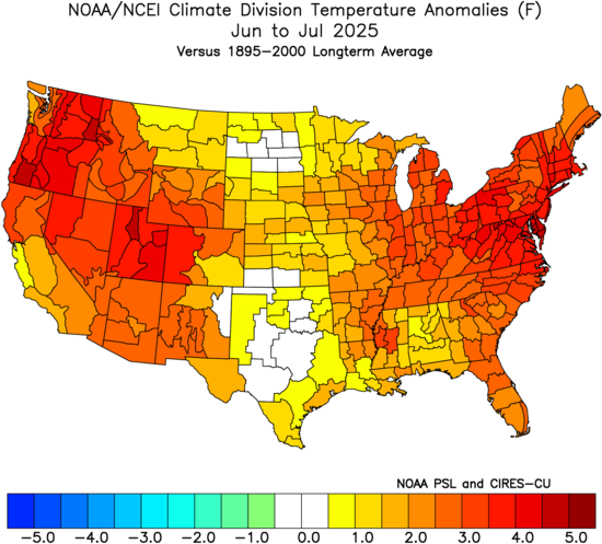
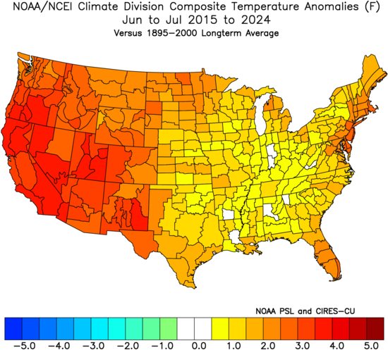
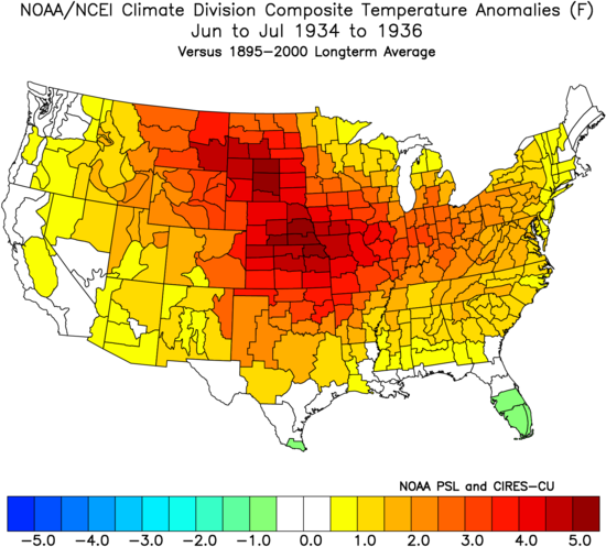
Yeah, this has been the opposite of the Dust Bowl pattern over the last decade. Record summer warmth in the West and East with less warm over the middle section of the CONUS. The Dust Bowl pattern had the record summer heat in the middle and cooler along both coasts.
-
Consistently more humid up near Hudson Bay than New England.
-
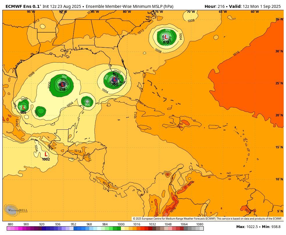
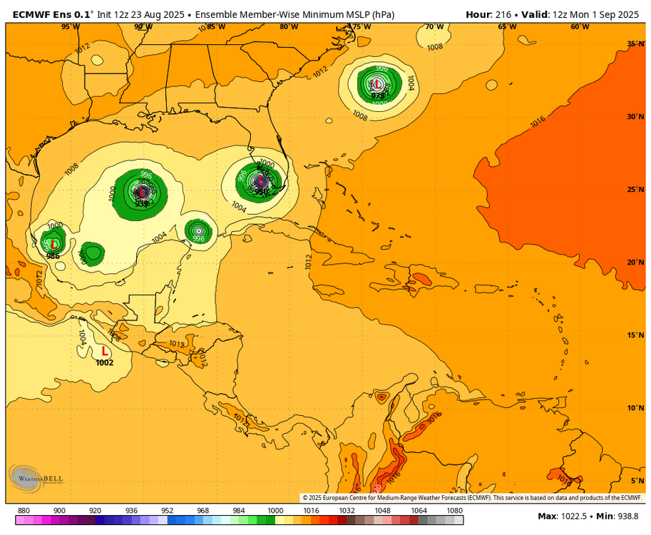
However, the 0Z Euro ens wasn’t nearly as active as the 12Z EE. The 6Z GEFS by my eyeballing has 5 (17%) TS+ members. So, not dead by any means but not all that active either.
-
Literally no one talking about 99L. Lol
-
Shut your mouth. lol Yes, we will pay[emoji3517] .