All Activity
- Past hour
-
Translation: Trends are unfavorable, but F**K it....lets obsess, anyway, given the notable absence of a social life-
-
tossed 3km nam has consistently done better for convection here so far this year
-
Anyway, Paul, you have known me long enough to understand I'm just teasing. I do appreciate your entusiasm for weather...savor that because you will probably never witness me admit it again.
-
This seems like a nowcast day. Models are all over the place on both initiation and coverage of convection.
-
You are usging this logic on the wrong person.
-
 DCA: 103 IAD: 101 BWI: 102 RIC: 100
 -
Just hit 80 / 73 here
-

2025-2026 ENSO
40/70 Benchmark replied to 40/70 Benchmark's topic in Weather Forecasting and Discussion
Obviously its ridiculously early, but there is some major work to do for us to see anything other than an east-based cool ENSO event take shape (assuming it is cool ENSO) given the evolution of the subsurface this spring. -
I am not sure what to think of with the HRRR...it really struggled in the midwest leading up to yesterday and even during the day.
-
What interesting SNE wx actually produces these days? We’re a poor man’s San Diego.
-
ehhh this is where people get super confused. Not every convective event is about severe weather. I'm a weather enthusiast, I enjoy thunderstorms and I enjoy snow. But I think it often gets misunderstood that whenever I talk about convection or say we have a chance for severe weather that it automatically means widespread severe weather, that is not the case. 99% of our convective events result in localized severe weather. Even in the Great Plains and midwest not every convective event is a widespread high-end event. Sure they get them wayyyy more frequently than we do. I get excited for thunderstorms...whether that comes with the chance for a 40 mph wind gust, pea hail, or just some heavy downpours with lightning. People get excited for 2-3 inches of snow in winter, don't they? or get excited just to see snow falling? It's the same concept, only difference is the scale of the two phenomena.
-
HRRR says SW CT may have some decent storms. But initiation is sort of varied on models.
-
We gain 0.05 seconds of daylight tomorrow to make the longest day of the year at 15H:06M
-
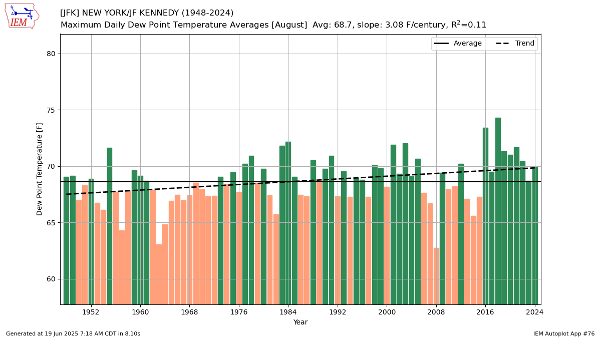
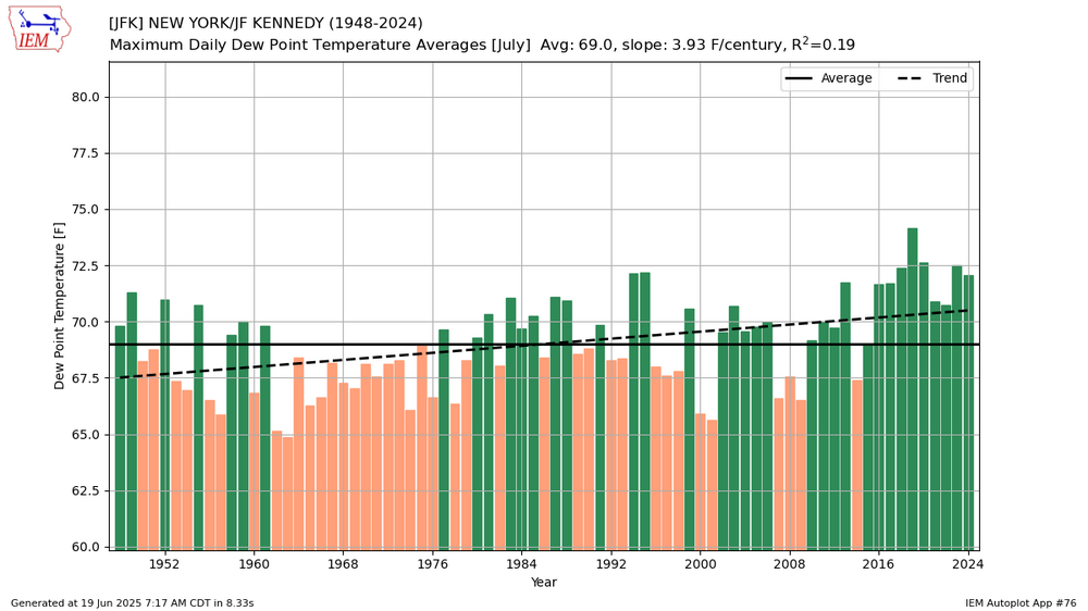
Yeah, spots like JFK have more subtropical dew points during the summers now which are similar to those experienced over the Delmarva 30 years ago. So the subtropical zones have been shifting north. We have seen this shift with winter snowfall and temperatures also.

-
That blessed stretch where Oak St beach might as well be Waikiki.
-
Have I ever told you how much of a POS the GFS is?
-
Are you suggesting that a SNE severe event maybe in peril?? Never could have foreseen that...
-
Major flooding in PA/NY state. https://nyheritage.org/exhibits/agnes-flood
-
Two days here next wk of maybe 90. I'm shaking in my boots
-
were you living down here back then? I remember you said you lived on Long Island growing up I think.
-
You could be a Nats fan right now too
-
so similar to 1993 but of a somewhat lower magnitude? That was one of those summers that was hotter the further west you went unlike 1993 which was hot throughout everywhere, my favorite summer before 2010. 1994 was more like 1988.
-
Agreed, this looks much worse than I was hoping to see this morning. Looks like dynamics aren't as strong as modeled and looking at the lapse rates was a big blow to the gut. The steep lapse rates (~ 7 C/KM) IMO were a big driver in the potential today. But who knows...maybe instead of widespread storms forming into a line we see more discrete stuff with the pre-frontal.
-
I remember Agnes. She messed up the end of my first grade school year.
-
1994 continued hot in July at EWR 16 90 degree days (99,98) 4 89 degree days Overall +3.6 for the month Aug was near normal