All Activity
- Past hour
-
1055mb High? Seriously?
-
Hope 06z euro come closer to gfs
-

Possible Record Breaking Cold + Snow 1/25 - 1/26
Franklin0529 replied to TriPol's topic in New York City Metro
Yea GFS went south a little. I'm not worried about that much though. Models are gonna move around. Just happy to see an intense storm still there -
We won't leave our houses for a week they will be using dump trucks with make shift plows and still won't keep up.
-
Kutchera I’d like 12-17 lol
-

January 24-25: Miracle or Mirage
SomeguyfromTakomaPark replied to stormtracker's topic in Mid Atlantic
Kuchera is 16.5 for dc, you would think we could actually get some decent ratios here on the northern side of this. -

2025-2026 Fall/Winter Mountain Thread
buckeyefan1 replied to Buckethead's topic in Southeastern States
The 6z gfs says mby will have 3.5” of snow, 6” of sleet and a little glaze to really lock it in. Good thing I have plenty of pto -
Check please!
-
TT maps look like 8-10 for dc.
-
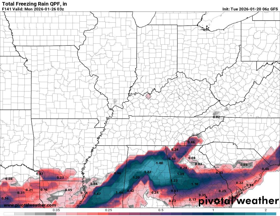
For the ice folks

-

Possible Record Breaking Cold + Snow 1/25 - 1/26
MJO812 replied to TriPol's topic in New York City Metro
Its great to see the Euro now on board. -
ZOINKS! .
-
And that was 10:1 ratio!!
-
1040mb High in NY state when the precip starts. Here's the potential we're looking at.. it counts sleet as snow depth, but a shift north would look like this
-
Ice?
-
Think you are looking at the wrong timestamp. GFS is only out to hour 132
-
Over a foot
-
Wow
.thumb.png.a69de9315794a143c20d5c8e6b7563bb.png)
-
We are witnessing diary of a madman in the storm thread
-
This may be the most absurd run the gfs has spit out… 15 inches… then sleet then back to snow in the foothills. .
-

E PA/NJ/DE Winter 2025-26 Obs/Discussion
Duca892 replied to LVblizzard's topic in Philadelphia Region
Think it might have been a slight small step back? But overall pretty identical to 0z -
Everything looks more backed up west
-
Still snowing on back side at 132 gonna be bigger then the blizzard.
-
It looks like it wants to come north. Juiced up
-
GFS has snow starting late Friday night and it’s still currently snowing on Tuesday. .


.png.782d0c3982b06c2b3bdc392309cf0525.png)

