All Activity
- Past hour
-
MPO has been fairly warm for September so far at +3.3°. The warm minimums are driving the departures there like in other places. The min departure is +4.0° and the max +2.7. You guys have only dropped to 47° by 9-8 which is the 2nd warmest low on record by September 8th. NYC is actually doing a little better than you guys by falling to 61° which is 3rd warmest. So this isn’t a UHI issue since all locations are experiencing warm minimums regardless of rural or urban settings. Time Series Summary for Mount Pocono Area, PA (ThreadEx) Warmest minimum temperature through 9-8 Click column heading to sort ascending, click again to sort descending. 1 2018-09-08 48 0 - 2002-09-08 48 0 2 2026-09-08 47 0 - 2015-09-08 47 0 - 2005-09-08 47 0 - 1996-09-08 47 0 Time Series Summary for NY CITY CENTRAL PARK, NY Warmest minimum temperature by September 8th Click column heading to sort ascending, click again to sort descending. 1 2015-09-08 63 0 - 1980-09-08 63 0 2 2022-09-08 62 0 - 2020-09-08 62 0 - 2005-09-08 62 0 - 1995-09-08 62 0 3 2026-09-08 61 0 - 2023-09-08 61 0 - 2018-09-08 61 0 - 2016-09-08 61 0 - 2014-09-08 61 0 - 2012-09-08 61 0 - 1996-09-08 61 0 - 1966-09-08 61 0 - 1959-09-08 61 0
-
They are also our "real winters". Long stretches of cold air, frozen lakes, long duration snowcover, ect. I love winter. Not just snow one day and 70 the next day. I'll take a Nina any winter. They also produce huge snowpacks east of Ontario where I'm moving during winters.
-

2026-2027 Record-breaking El Nino
EasternLI replied to Stormchaserchuck1's topic in Weather Forecasting and Discussion
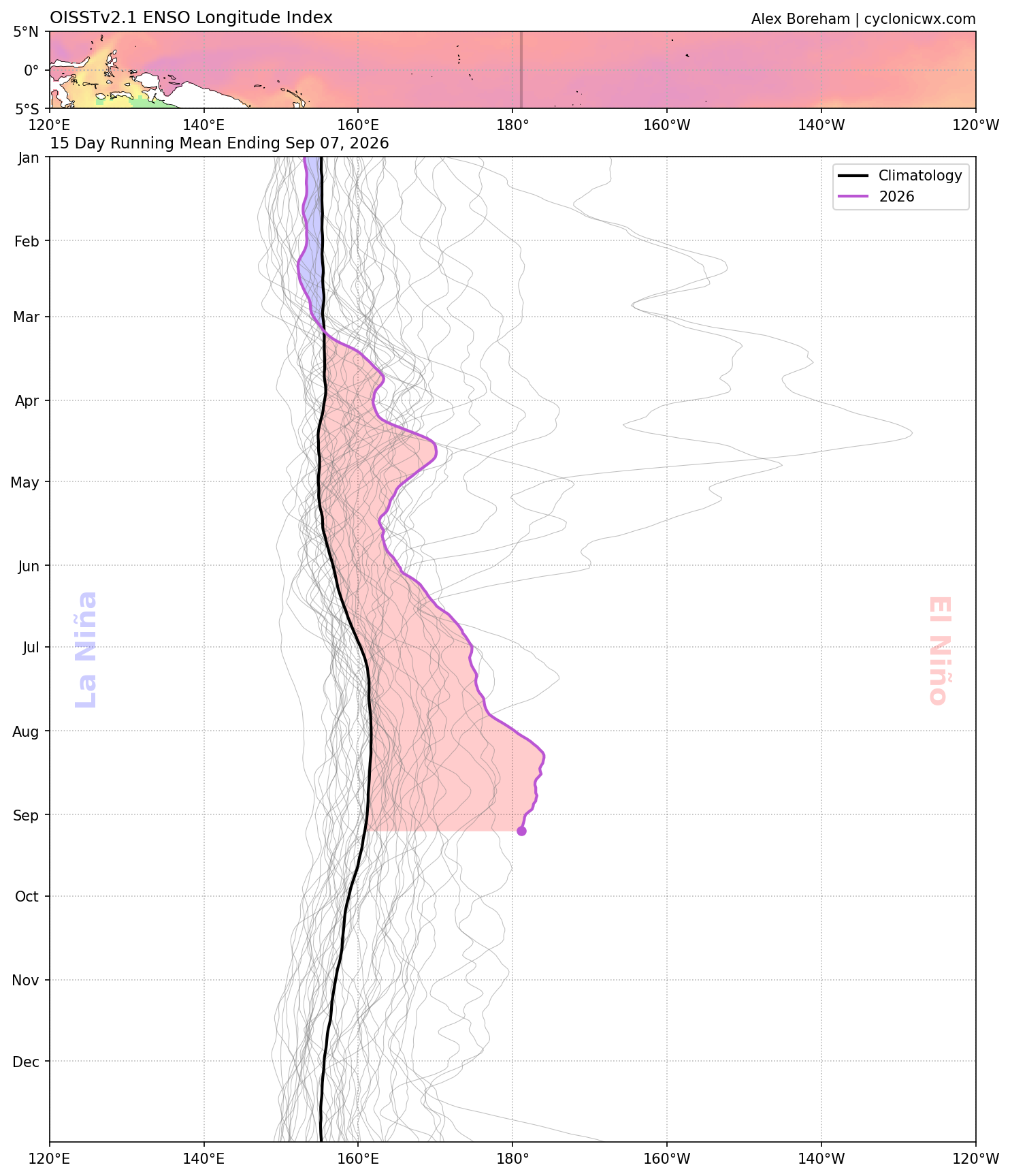
Current WWB verifying a tick stronger vs what models had advertised. Same thing happened with the last one too. -
However most of our recent shut out torch fests been during niñas.
-

Central PA Summer 2026 Discussion/Obs Thread
Mount Joy Snowman replied to Voyager's topic in Upstate New York/Pennsylvania
64 when I left, 61 through the rurals with some valley fog. Dews on the rise for a couple days. Onward. -

2026-2027 Record-breaking El Nino
bluewave replied to Stormchaserchuck1's topic in Weather Forecasting and Discussion
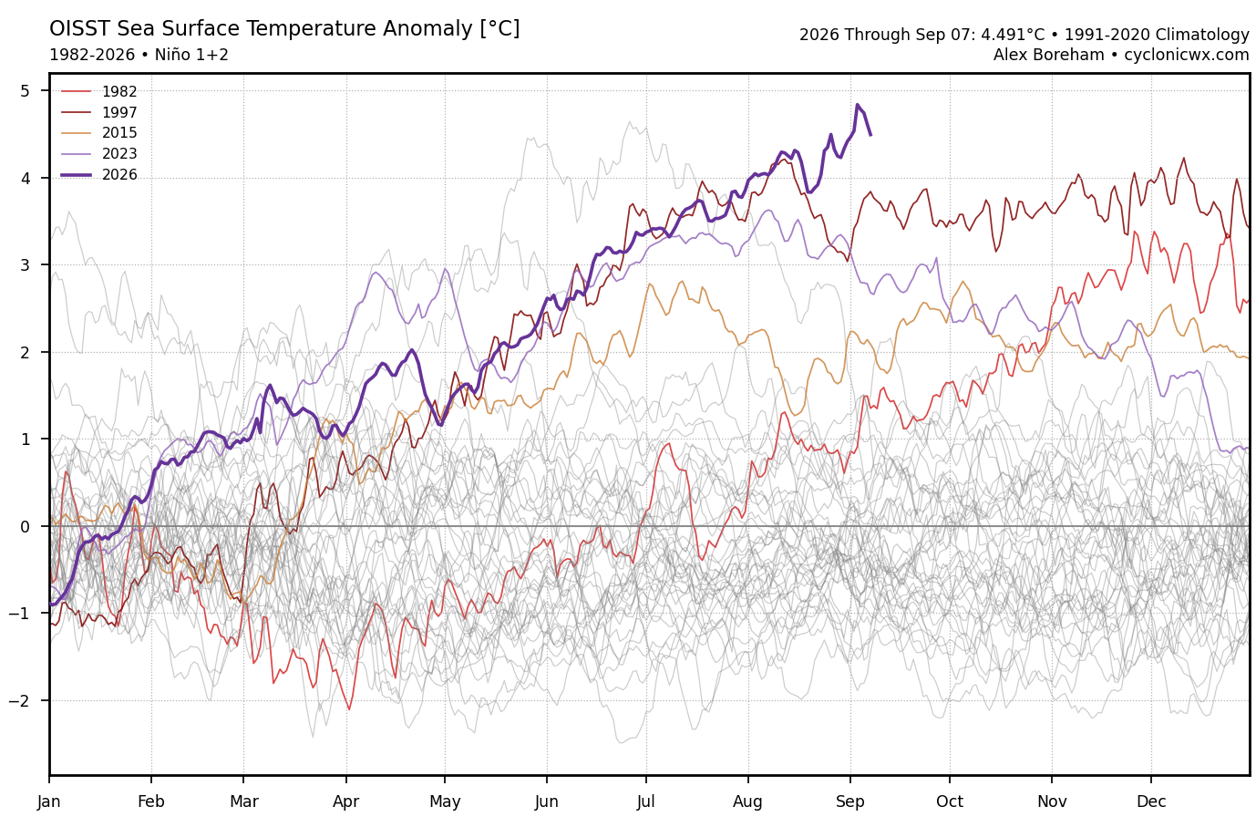
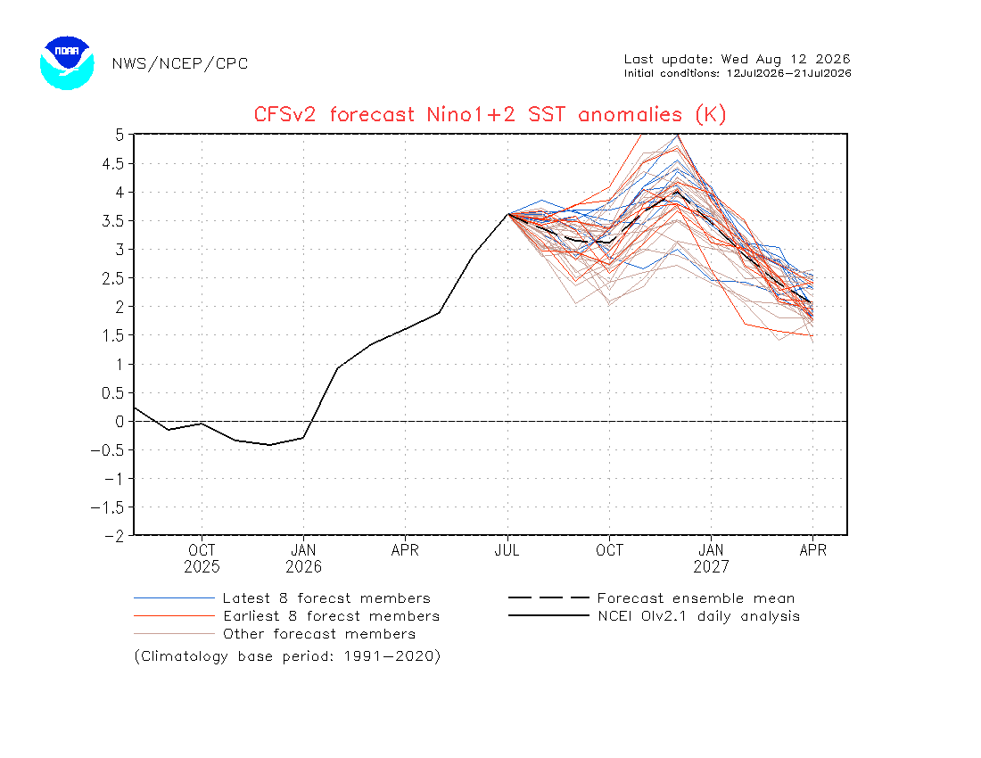
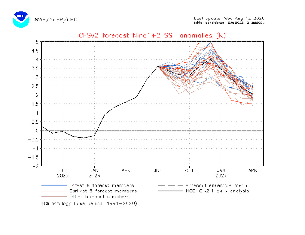
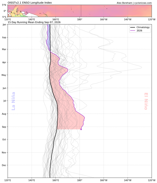
The CFS really missed how east based this event has become. The most recent update for this week is a record breaking +4.6 in Nino 1+2. The forecast for early September was only around +3.3.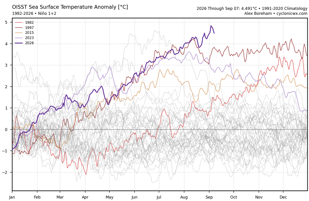
-

Septorcher 2026 Discussion - Endless Summer
Brewbeer replied to Damage In Tolland's topic in New England
man, what a night last night, another with windows open and a fan on low, great for sleep (if you can) currently 60/60, will we need the house ACs later today for one more day this season ? - Today
-
.thumb.jpg.6a4895b2a43f87359e4e7d04a6fa0d14.jpg)
Central PA Summer 2026 Discussion/Obs Thread
Yardstickgozinya replied to Voyager's topic in Upstate New York/Pennsylvania
All I need is some distant lightning and rumbles of thunder to enhance my evening but I wonder if I will even get that. Area Forecast Discussion National Weather Service State College PA 416 AM EDT Wed Sep 9 2026 .WHAT HAS CHANGED... * WPC added a MRGL Risk (level 1 of 4) for excessive rain on Saturday across Southern PA. && .KEY MESSAGES... 1) Heat and humidity will peak today. 2) Showers and scattered strong to potentially severe thunderstorms, with the threat for localized gusty to damaging winds for late today and early tonight, mainly across the NW third of PA. && .DISCUSSION... KEY MESSAGE 1: Heat and humidity will peak today. Increasingly southwesterly flow at the surface and aloft will carry warm and humid air into the region today, well in advance of a cold front moving southeast across the Upper Great Lakes. A gradually narrowing SW-NE axis of very high PWAT air (1.8 - 2 inches) will reach the south shore of Lake Erie during the early afternoon, then sag SE across the NW Mtns early this evening before reaching the Southern Tier of PA before daybreak Thursday. This will be a 0.5 to 0.75 inch increase in PWAT over the upcoming 15 hours which will make it feel much more uncomfortably humid later today and much of tonight. The late day/nighttime peak in the won`t result in high heat indices today with apparent temps only about 3-4 deg F higher than the actual temps. High temperatures will be around 2 to 4 degrees warmer than they were today, generally ranging from the low to mid 80s. Heat index values may touch the 90F mark in the south central mountains on Wednesday as dewpoints climb back into the mid to upper 60s. Rain-free conditions will prevail for much of the day, though we should start to see thunderstorms develop over northwest PA by the evening. -------------------------------------------------------------- KEY MESSAGE 2: Showers and scattered strong to potentially severe thunderstorms, with the threat for localized gusty to damaging winds for late today and early tonight, mainly across the NW third of PA. Surface low pressure system will be moving across northern Ontario with a cold front extending south/southwest through the Great Lakes and Ohio Valley. Tightening llvl pressure gradient will lead to an increase in synoptic scale/gradient winds this afternoon into Thursday. Wind gusts will increase in into the 20s today on the hilltops and also across the Lower SUsquehanna Valley. A gust near 30MPH is possible on the tops of the Laurels Wed night just before the front. The cold front will provide enough lift of the airmass, (containing a high shear/relatively low instability environment) to create numerous showers and scattered, embedded thunderstorms, with the majority of this convection occurring before the front passes later tonight in the north and Thursday morning in the south. There is some potential for severe weather across northwest PA with these storms as confidence in favorable overlap of CAPE and shear continues to increase with SPC maintaining similar areal coverage of their slight risk of severe weather. Most guidance (including the latest HREF) shows 500 to 1200 J/kg of MUCAPE developing out ahead of the front, with the highest values concentrated over our northwestern counties. Coinciding with this will be an increase in 0-6 km westerly bulk shear, with values between 40 to 50 knots. This should support some fast-moving discrete cells, growing upscale into some line segments containing mini bows with an enhanced threat for wind damage late today/this evening from Warren to Bradford and points about 40 NM to the South. Model soundings do show some turning in the lowest 0-3 km in association with a 40 to 45 knot low-level jet, and a few transient supercell structures or circulations embedded in linear segments cannot be ruled out. SPC has included a 2% tornado contour that covers much of the slight risk area. Showers and thunderstorms should weaken as they move south and east through the night into a more stable airmass. However, they will still be capable of producing localized heavy downpours. The current WPC outlook for Thurs paints a SLGT risk of excessive rainfall over portions of Cambria and Somerset Counties. Some CAMs show the potential for up to an inch of rain to fall into Thursday morning in the slight risk area, though most guidance would suggest that up to half of an inch of rain is the more likely outcome. Even though flash flood guidance is relatively low in these areas, the potential for any flash flooding appears to be low at this time unless any areas see training thunderstorms develop. High pressure builds behind the cold front, giving way to a dry and sunny Friday. Low level moisture lurking just south of the Mason/Dixon line Fri/Fri night will advance NE across the state on Saturday as SFC high pressure moves well off the Mid Atlantic and Southern New England Coast. This will lead to some showers spreading NE across the region with a few PM TSRA possible Saturday and/or Sunday afternoons, especially over the western mtns. A more- active (wetter) pattern is in store for Mon-Tues. But, the flat upper ridge over the southern half of the CONUS will make it difficult for deep moisture to make it into PA ahead of any shots of atmos forcing. The second half of the week probably ends dry as the upper ridge pumps up over the central CONUS. -

E PA/NJ/DE Autumn 2026 Obs/Discussion
Birds~69 replied to PhiEaglesfan712's topic in Philadelphia Region
63F/DP 60F at 5am. Warm and breezy day upcoming... -
 cost of propecia without rx and propecia brand name cost cheap propecia https://maps.google.at/url?q=https://hairguardrx.shop buying generic propecia tabletsand http://bbs.51pinzhi.cn/home.php?mod=space&uid=8301702 get generic propecia pills [url=http://stopundshop.eu/url?q=https://hairguardrx.shop]buying cheap propecia price[/url] cheap propecia without insuranceor [url=https://www.0468wudi.com/home.php?mod=space&uid=272393]order cheap propecia without a prescription[/url] propecia pills
 -
purchase cytotec: CytoCarePharma ~ order cytotec online
-
buy generic propecia without insurance: HairGuardRx - buying cheap propecia online
-
That's a monster +AO pattern lol Since the Solar Max peak in 2024, the warm seasons 2024, 2025 and 2026 have been very +ao. I think it's more of a decadal state, and just minimizes the potential for 09-10 type -NAO or 15-16 type +PNA
-
A seasonal model is never going to predict more than like a +3F month. That's because their accuracy is low and they have a large range of error. East-based Nino/-PDO is about as bad as it gets for long range predictors of Winter CONUS warmth. Hopefully the AO help this year. Baltimore/DC average high never really goes below 40 so we do need some below average temps.
-
Central PA Summer 2026 Discussion/Obs Thread
Yardstickgozinya replied to Voyager's topic in Upstate New York/Pennsylvania
I appreciate Bobby's video forecast. His forecasts are fast, straight to the point and his daily video forecasts are available about as early as anyone that i'm familiar with on youtube . -
http://cytocarepharma.shop/# п»їcytotec pills online
-
Heavy showers have moved from offshore W to my home at 1:40AM, a total surprise!
-
buy cytotec over the counter or buy cytotec over the counter Abortion pills online http://oko.ikrim.net/go.php?http://cytocarepharma.com cytotec abortion pill or https://www.hapkido.com.au/user/qlvrdzmbkrgmail-com/ buy cytotec pills online cheap [url=https://www.google.gy/url?q=https://cytocarepharma.com]buy cytotec pills[/url] buy cytotec pills online cheap or [url=https://exhibitioncourthotel4.co.uk/user-2/gfmyhcqqzo/?um_action=edit]cytotec pills buy online[/url] buy cytotec over the counter
-

2026-2027 Record-breaking El Nino
GaWx replied to Stormchaserchuck1's topic in Weather Forecasting and Discussion
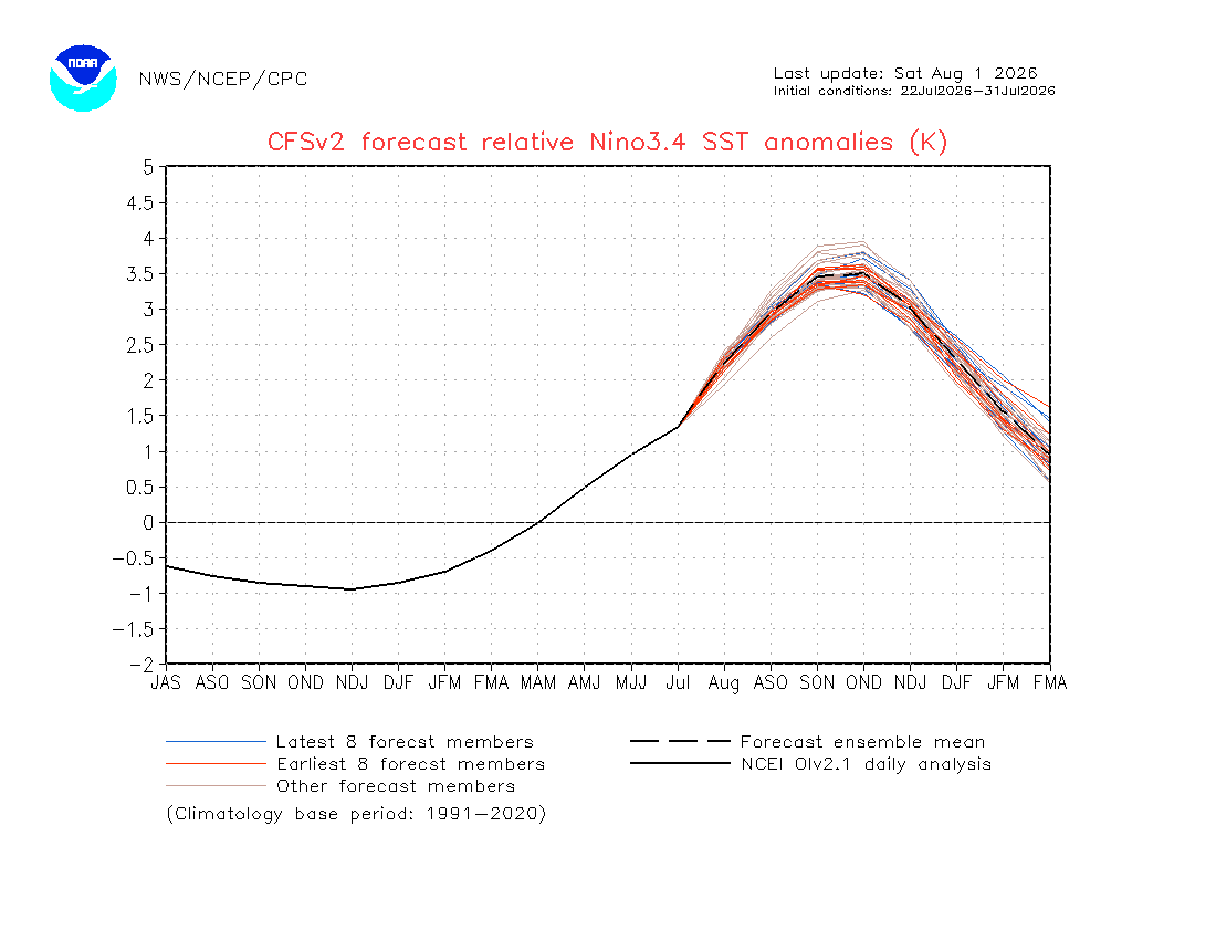
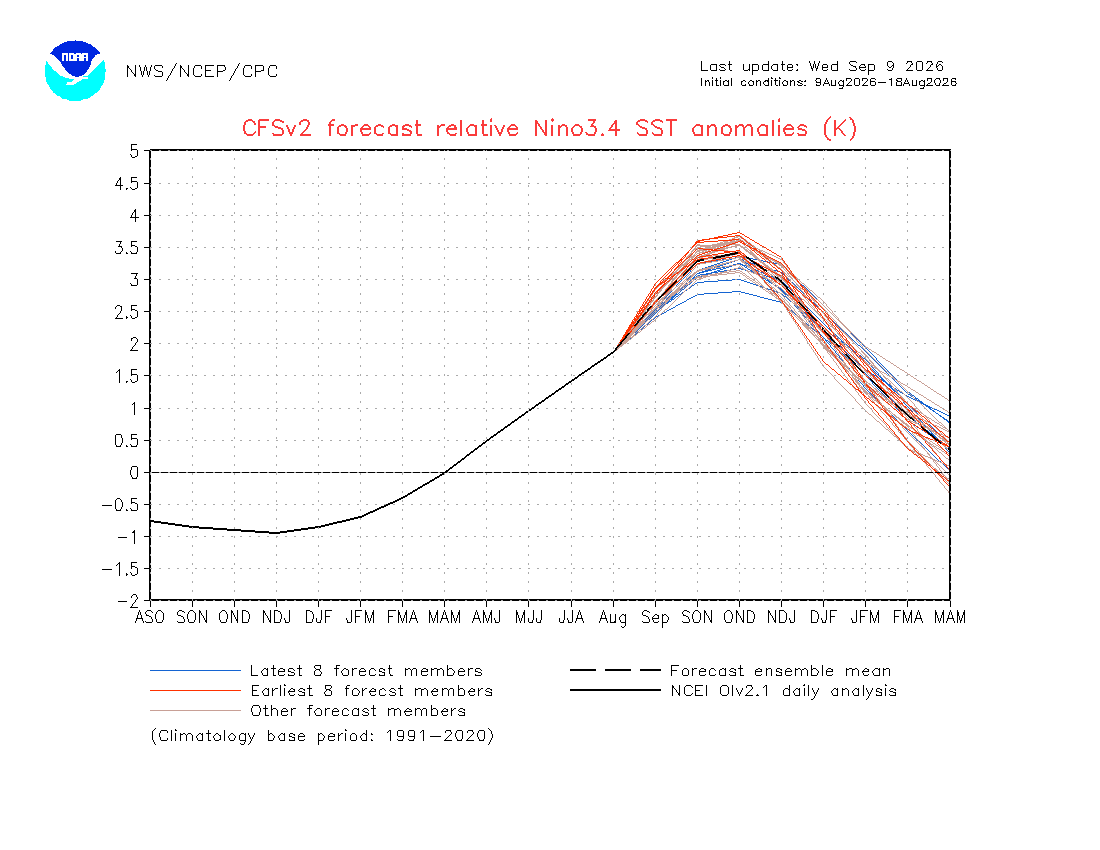
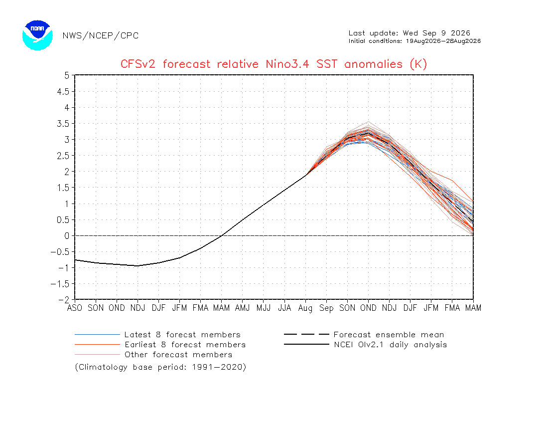
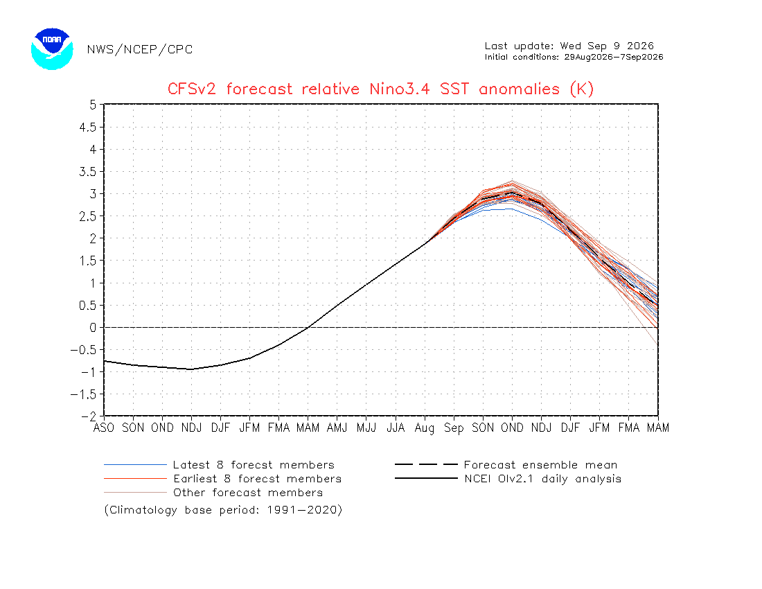
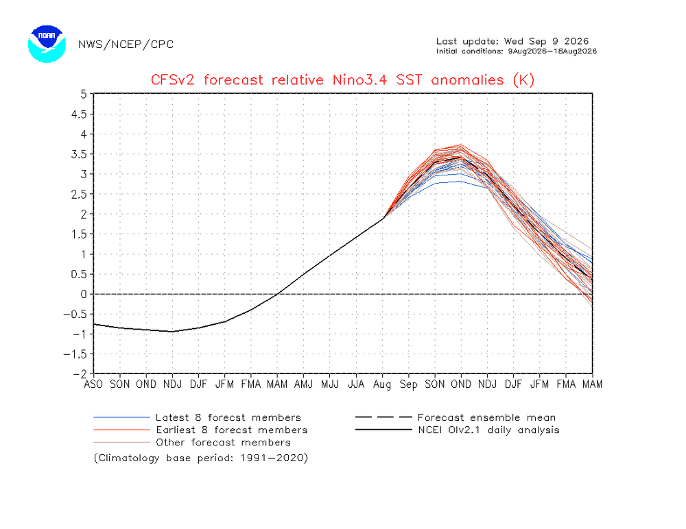
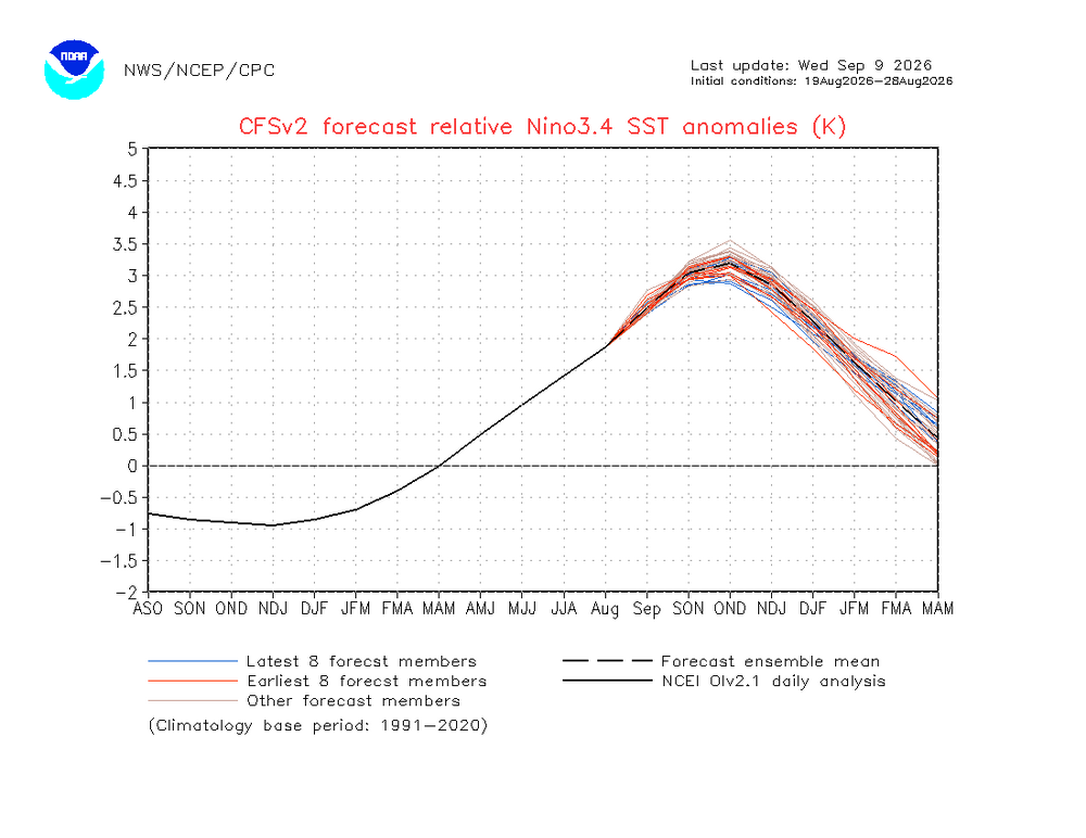
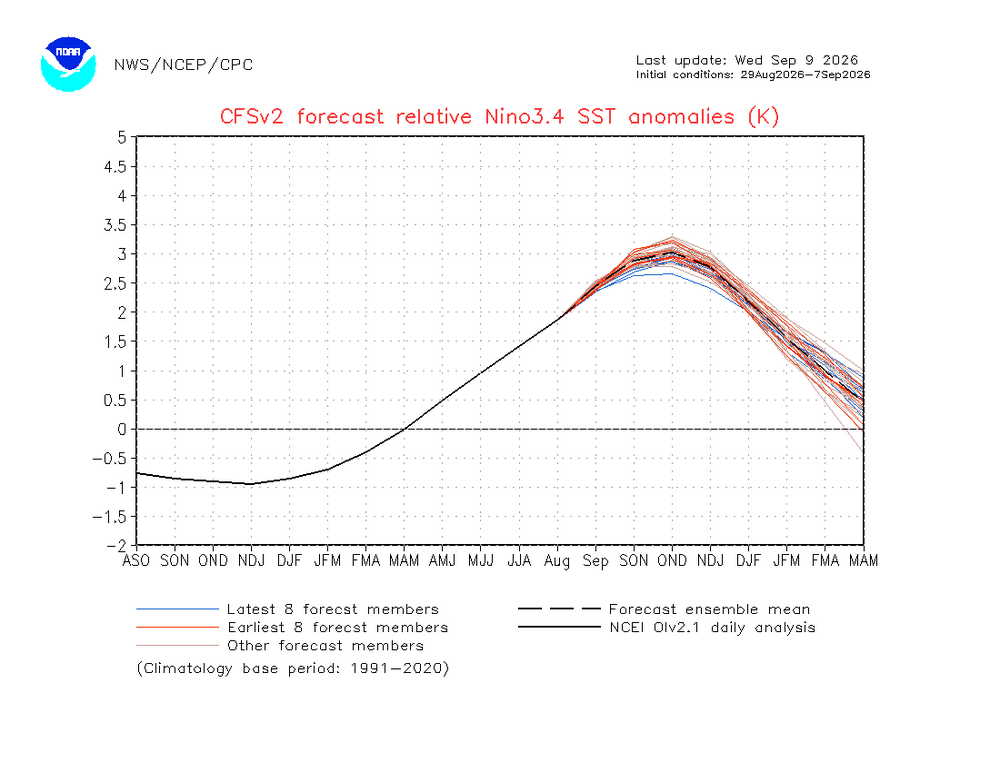
The CFSv2 progged RONI peak continues to drop steadily with more drops likely: 7/22-31: ASO/OND +3.5 8/9-18: OND +3.45 8/19-28: OND +3.2 8/29-9/7: OND +3.0 with most of the blue lines (most recent 8 runs) lower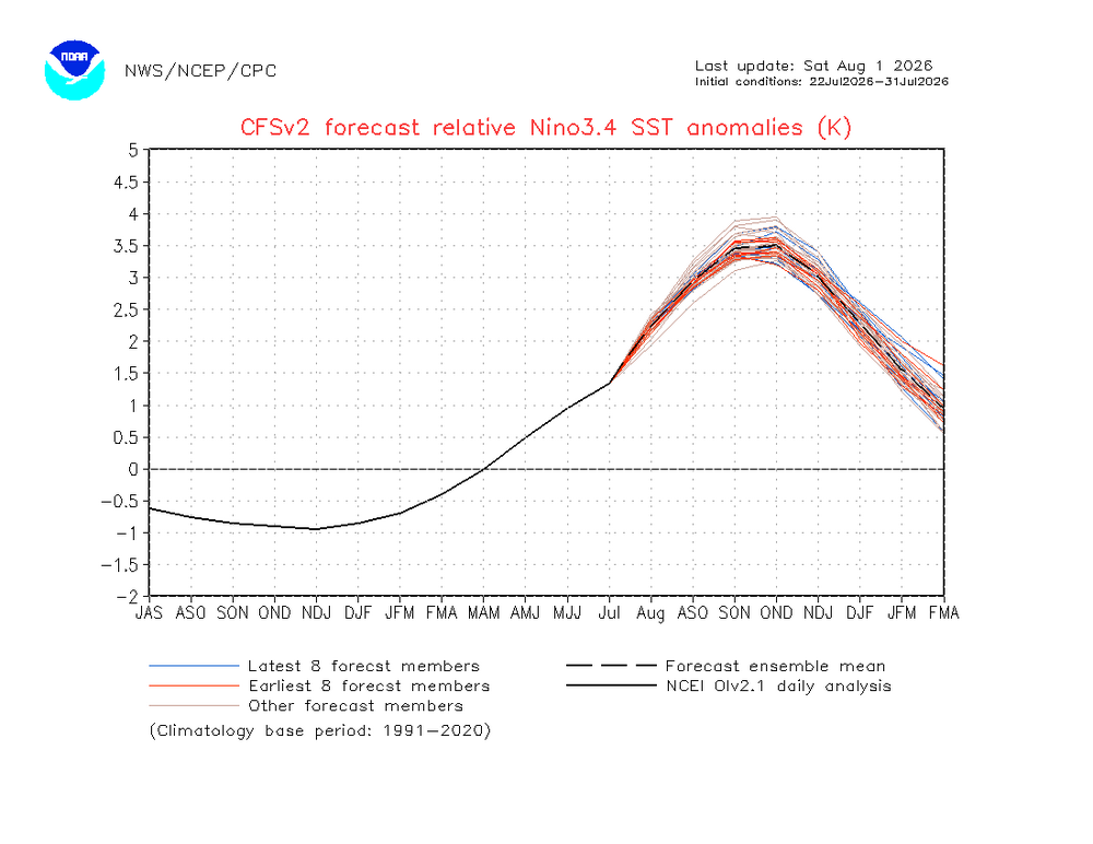
-
buying generic propecia no prescription [url=http://hairguardrx.com/#]order propecia pills[/url] and buy cheap propecia tablets
-

2026 Atlantic Hurricane Season
WxWatcher007 replied to Stormchaserchuck1's topic in Tropical Headquarters
Very interesting looking at the images from the respective years. This year’s Atlantic has really warmed up compared to earlier in the season though we’re seeing most of the warmth in the subtropics. -
buy cytotec pills online cheap: purchase cytotec or buy cytotec in usa
-
buy cheap propecia without insurance: buy generic propecia or cost generic propecia no prescription
-
Not for me. 9 months of grey skies and cool to cold weather here where I have to wear slippers inside during those 9 - this is still fresh as a daisy.
-
https://hairguardrx.com/# cost of propecia online