All Activity
- Past hour
-
Yup. Partly sunny and steamy today. Will the storms produce today or not. That is the question...
-
dry ground and an offshore flow is great for days like this
-
There's a couple that want 60 and rain.
-
93/74 hoping for storms today or tomorrow.
-
There are also storms modelled for tonight around 11pm-12am
-
Record setting ice-out date for Moosehead. 80/62
-
80's to the coast, mostly clear skies through the evening..can't ask for much more if it verifies
-
We gfs for the 4th
-
Another overperforming day. 91 currently
-
93 based on the pre-2000 regression equation.
-
89 so far.
-

July 2025 Obs/Disco ... possible historic month for heat
Typhoon Tip replied to Typhoon Tip's topic in New England
omg, that's so funny. Not joking, I literally just said in my mind that exact same sentence. that's weird -

July 2025 Obs/Disco ... possible historic month for heat
Sey-Mour Snow replied to Typhoon Tip's topic in New England
6-8 day heat wave on the 12z gfs a lot of days 94-98... -
July 2025 Obs/Disco ... possible historic month for heat
Typhoon Tip replied to Typhoon Tip's topic in New England
For shits and giggles ... these are the ICON's 2-m Ts for 18z a week from today -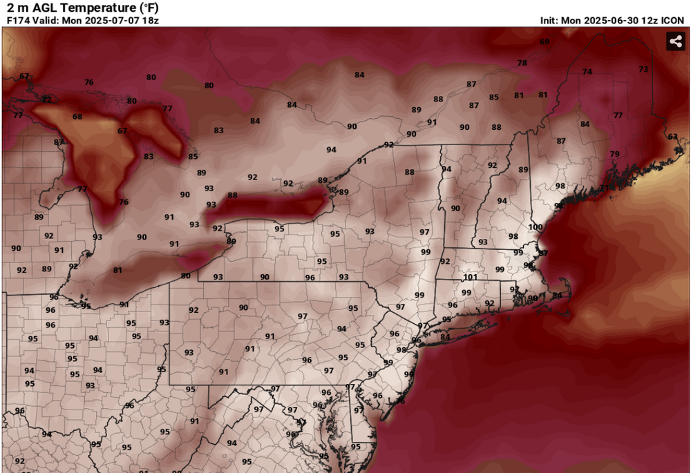
-
 chapsy joined the community
 -
Thanks Tony, this is truly epic BBQ weather!! Even some natural fireworks at night pre July 4th!!
-
Over 4” of rain here this month. But a vast majority of that was during the first week or so
-
NAM 3km and HRRR have a pretty good round of showers/storms tomorrow but pretty late, around 8 to 10pm. Hopefully we'll get a decent soaking either from that or the potential round overnight tonight.
-
wow my 102 guess for June 24 was correct.... I just saw your very excellent post, Don. I've always wondered if we could do temperature corrections like this. I'm guessing Central Park should have reached 90 yesterday too? It just hit 91 here Don, I'm guessing Central Park is a bit behind again today?
-
It just hit 91 here Don, I'm guessing Central Park is a bit behind again today?
-
July 2025 Obs/Disco ... possible historic month for heat
Typhoon Tip replied to Typhoon Tip's topic in New England
12z operational GFS is approaching 600 dm SSE of Cape Cod while the whole NE region is immersed in 588 + dm ridge node, with a plume of trapped +21C 850 mb air rattling around inside of it resonating to the diurnal cycle. That's at D7.5 so likely to modulate in future guidance, but that's obviously an implication of something more than merely AN later next week. -
You posted the records from all my favorite heatwaves Chris-- THANK YOU!!! The only ones you left out were July 1983, August 1983, September 1983 (three from that historic summer lol), July 1993, July 1999, July 2010 and July 2011. More recent but a fair comparison my friend. By the way no way no how Central Park did not hit 100 degrees for their earliest triple digit reading last week. Based on the fact that Central Park is usually hotter than LGA when on a NW wind (or should be), I'd estimate they should have been 102 on that day (the same as JFK) and should have also hit 102 on the day after (the same as JFK again). Something is really vexing me though. Our local TV mets are proclaiming the Central Park temperatures to be valid and even claiming verification based on them. WABC's prediction for 6/24/2025 was 98 degrees and when the Central Park high was 99 they proclaimed they were correct in that New York City would be close but not hit 100 degrees. Likewise when Central Park only hit 89 yesterday they said they were correct again (their prediction was 88 degrees) when they said New York City would be close but not hit 90. They treated LGA and JFK like outlier suburban stations (JFK is too far south that's why it's hotter, LGA is north of us and likely influenced by hotter inland air from the lower hudson valley is what they said.)
-

2025 Atlantic Hurricane Season
WxWatcher007 replied to BarryStantonGBP's topic in Tropical Headquarters
I’m probably the biggest NHC naming defender here, but at least at the time it was named, Andrea was a joke. In the 24 hours or so before being named I recall that system being close to a TC, but when it was named it was little more than a swirl devoid of nearby convection. Barry was slop, which is what you’d expect in June, but it was legitimate. Recon found a sharp wind shift, there was persistent convection, and eventually recon sampled TS force wind. It made landfall as a depression. You’re not going to get a ton of ACE or eye candy from a subtropics swirl and a low that was the beneficiary of BoC magic in June. -
I was hoping the dry conditions would kill off the lanternflies =\ Usually the drier it is the less pests/bugs we have.
-
2010: The hottest June on Record! The Richmond International Airport reported the mean temperature for June was 81.1 °F which was a new 113 year record. This breaks the old record of 79.2 °F set in 1943 and was a +8.7 °F departure from average. June had 8 new daily temperature records and all were for heat. Both June 27th and 28th had a maximum temperature 102 °F. Richmond has never had back to back 102 °F days before in June. Only three June days have been hotter: (June 30, 1937 103 °F) (June 19, 1944 103 °F) (June 26, 1952 104 °F ) June 2010 also had 19 days of 90 °F or higher temperatures the record was 20 in 1943. June had only 0.82 inches rainfall making it the second driest in 113 years only 1980 was drier with only 0.38 inches and with the heat made severe drought conditions. (Ref. Richmond Weather Records - KRIC)2010: Both Philadelphia, Pennsylvania, and Washington, D.C. recorded their hottest Junes, with the thermometer in Philadelphia averaging 5.9°F above normal for the month. Miami, Florida notched not just its hottest June, but its hottest month on record.(Ref. Weatherwise U.S. Weather Highlights of 2010 page 8 ) Summer 2010 was to summer what 1995-96 was to winter!!
-
Me too. It has gotten to the point that we could use some rain again. I had to give the garden a good watering yesterday. I know we have a pretty good chance of storms tomorrow, but I'm hoping the models are right about a round of rain happening overnight tonight.


