All Activity
- Past hour
-
The euro ai is impressive to say the least. Neural networks ftw, though the black box, lack of interpretability of nn’s needs improvement.
-
No I would absolutely be cautious. I'm still cautious but let's be real here the euro just isn't a great model anymore. Euro ai is!
-
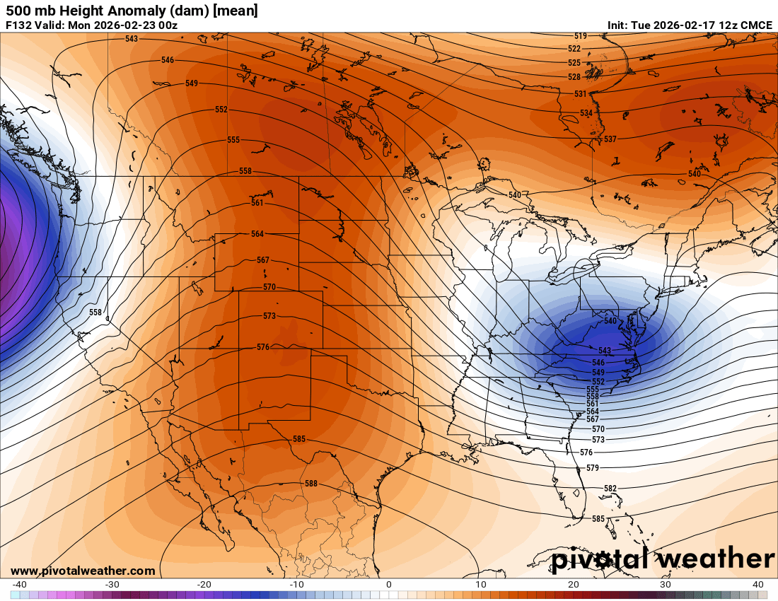
The GEPS showing similar trends to the AIFS ensemble, though today's 12z run is a bit more suppressed than the 0z as the trough turns negative tilt near the NE US coast.

-
They were but...lol...euro totally missed the 14" we got the evening before...and then still was about .5 qpf too low for the second part. It was a pretty epic fail of the euro at very short lead
-

“Cory’s in NYC! Let’s HECS!” Feb. 22-24 Disco
Typhoon Tip replied to TheSnowman's topic in New England
If the set up successfully gets there, sure. -

Late February/Early March 2026 Mid-Long Range
SomeguyfromTakomaPark replied to WxUSAF's topic in Mid Atlantic
Not worried about the euro, it’s been getting slapped around by its ai cousin from this range all winter. I’m more just worried about the ai shifting this whole thing northeast as we get closer which of course could happen. -
i think a MECS is totally possible, but would like to see the EPS jump on board soon
-

E PA/NJ/DE Winter 2025-26 Obs/Discussion
Snowguy66 replied to LVblizzard's topic in Philadelphia Region
F DT. He occasionally gets one right but is often wrong. -
you on board for a SECS or MECS ?
-
so you on board for a SECS or MECS ?
-

Central PA Winter 25/26 Discussion and Obs
canderson replied to MAG5035's topic in Upstate New York/Pennsylvania
Today has killed off all snow in my front yard and side garden. Even shoveled piles. -

Pittsburgh/Western PA WINTER ‘25/‘26
jwilson replied to Burghblizz's topic in Upstate New York/Pennsylvania
Might have to enjoy next week as the last week of winter. I think the Sunday event is mostly a coastal, either way - scrape or out-to-sea. Doesn't appear to have a lot of intrigue for our area. I can see one or two other snow chances. Nothing major yet. Incoming March pattern looks like straight-up pacific firehose of warmth for most of the CONUS. I'm more of a November and December snow guy, truthfully. March is often a wildcard, but if I had to choose, I'd take early season wins over late ones. Our bigger March snows seem to pop every five years on average. Next year would be five years since a healthier March snow total (17.1" in 2022). The pattern can always flip colder mid-or-late March, but by then you're asking a lot for true snow events. -

E PA/NJ/DE Winter 2025-26 Obs/Discussion
MickeyTim6533 replied to LVblizzard's topic in Philadelphia Region
MA forum starting to get concerned. apparently the GEFS suck -
Lots of Tucked members off the coast.
-
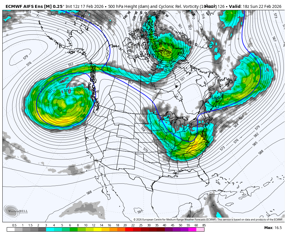
Impressive four run trend from the AIFS ensemble. Note the western ridge trending further west and more amplified. Meanwhile the combination of the ridging east of Hudson Bay and trough over SE Canada exerts less of a suppressive influence, allowing the Sun-Mon trough to amplify more.
.thumb.gif.0e2c4df72f4ea87ea3b84db85b610251.gif)
-

“Cory’s in NYC! Let’s HECS!” Feb. 22-24 Disco
brooklynwx99 replied to TheSnowman's topic in New England
i will 100% take this at this range
-
Your ratios must have been bigly! lol
-
i will 100% take this 5-6 days out, let the chips fall where they may

-
lol absolutely not, if the euro was the only model showing a hit without the support from the AIFS it would be tossed in the trash
-
I remember that. Was up in Lancaster for that event and the Euro blew chunks on that storm. The 00z Euro on 2/9/10 only had us around 0.5" QPF (I was the lead forecaster for campus weather service that night). Everyone rightfully saw that as a red flag for the event, but the UKMET, GFS, Canadian, and NAM were all in lock step. We ended up with 18" - 22" in Lancaster from that. The night before, the NWS had us at 6" - 12".
-
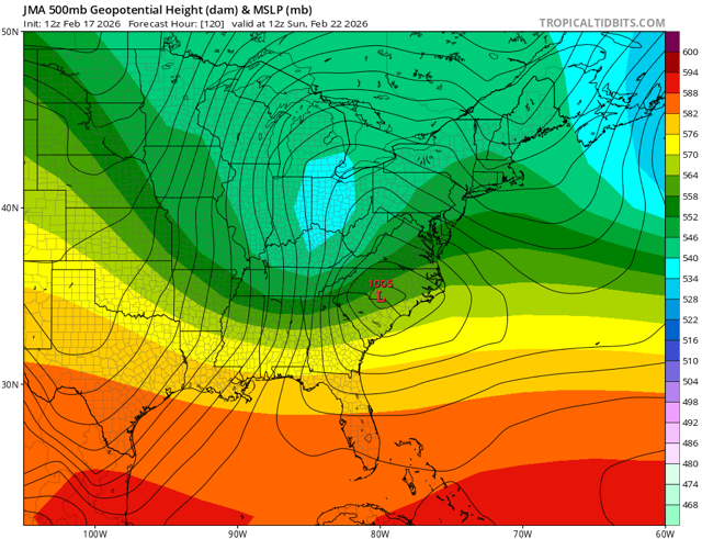
I know it’s just the JMA, but it’s another piece of guidance not on the euro op camp
-

“Cory’s in NYC! Let’s HECS!” Feb. 22-24 Disco
ineedsnow replied to TheSnowman's topic in New England
stormvista down for me -
“Cory’s in NYC! Let’s HECS!” Feb. 22-24 Disco
Typhoon Tip replied to TheSnowman's topic in New England
It's also slightly S-E of previous mean -
Euro is not always right as we found out plenty of times. If it had some support from like anything I’d be more worried but attm it and it’s ens to an extent are by itself, it’s AI partner not even on board with it.
-
“Cory’s in NYC! Let’s HECS!” Feb. 22-24 Disco
ineedsnow replied to TheSnowman's topic in New England


.gif.f47dc26460d8986c855b15b25da5fe37.gif)