All Activity
- Past hour
-
Relatives coming in Friday morning and gave me a Christmas present by saying that they extended their stay until January 4th. I call that a “lose-lose” At least I can have time alone snow blowing the driveway Friday night hoping for 4-8”. We’ll see.
-

26th-27th event, coming at us like a wounded duck.
Ginx snewx replied to Go Kart Mozart's topic in New England
How many will go to the bathroom to check models during Christmas dinner? Lol sickos -

26th-27th event, coming at us like a wounded duck.
Kitz Craver replied to Go Kart Mozart's topic in New England
Take em up! -

Central PA Winter 25/26 Discussion and Obs
WmsptWx replied to MAG5035's topic in Upstate New York/Pennsylvania
Sounds like it's over by early Saturday morning. I also just peeped the point and click and the cold air that was supposed to come seems to have died. -

26th-27th event, coming at us like a wounded duck.
tavwtby replied to Go Kart Mozart's topic in New England
bit shocked they went straight to warning, but I guess they are figuring in travel etc., I'm expecting low end of that 5-7", but we'll have to see where the banding sets up, should go to town for a few hours overnight anyway. -
Mike Masco is going with 6-10 for NYC south until CNJ with 10 plus for the interior areas.
-
26th-27th event, coming at us like a wounded duck.
Ginx snewx replied to Go Kart Mozart's topic in New England
Here we go WINTER STORM WARNING IN EFFECT FROM 4 PM FRIDAY TO 1 PM EST SATURDAY... * WHAT...Heavy snow expected. Total snow accumulations between 5 and 7 inches. * WHERE...In Connecticut, Northern Litchfield and Southern Litchfield Counties. In New York, Eastern Dutchess, Eastern Greene, and Western Dutchess Counties. * WHEN...From 4 PM Friday to 1 PM EST Saturday. * IMPACTS...Roads, and especially bridges and overpasses, will likely become slick and hazardous. Travel could be difficult. The hazardous conditions could impact the Friday evening commute. * ADDITIONAL DETAILS...Moderate to heavy snow will develop around or just after sunset Friday, and will remain heavy at times Friday night. Snowfall rates of 1 to 2 inches per hour will be possible Friday evening. The snow gradually -
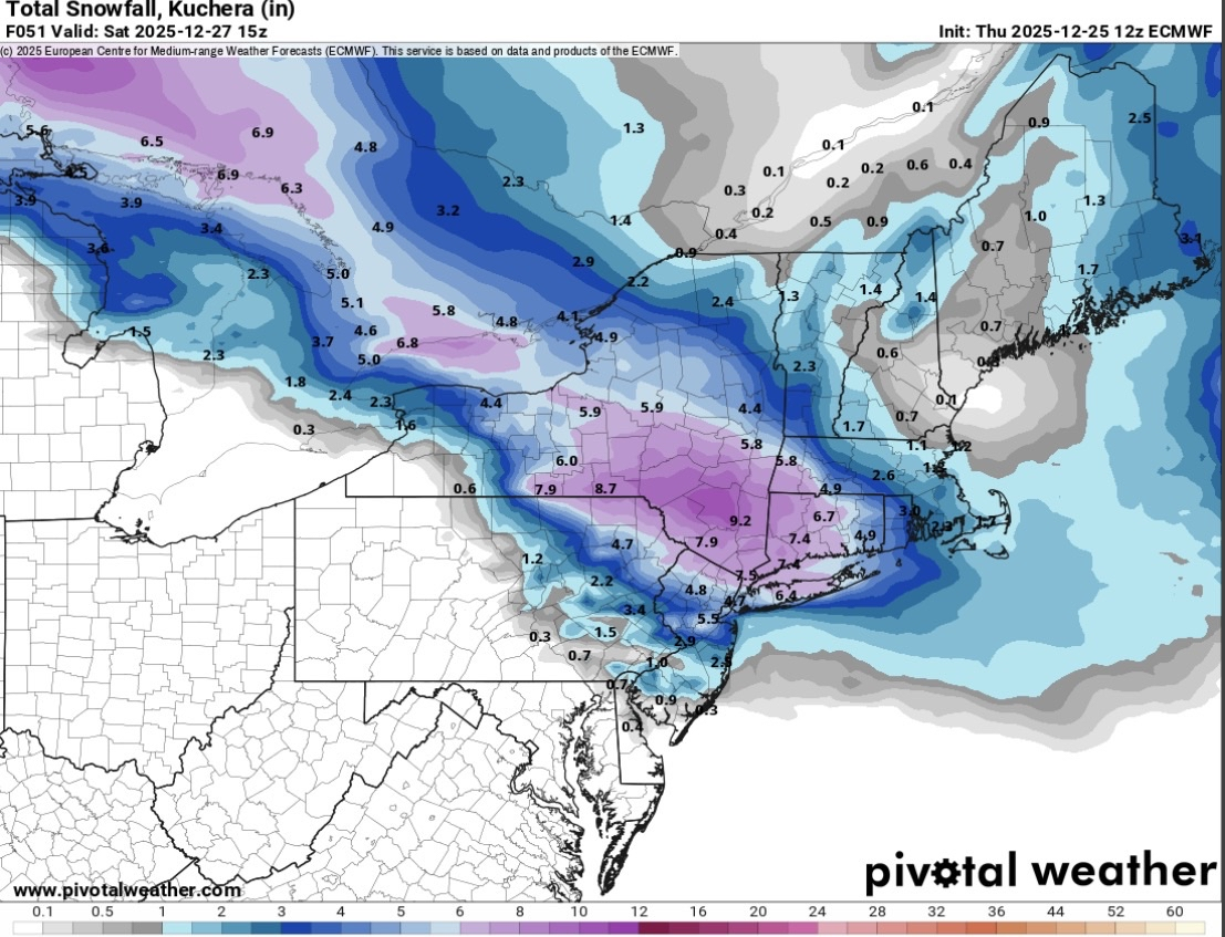
Kuchera

-
I've been debating this one. I'm calling it a white Christmas as of 7am observation, and I believe official time to declare a white Christmas or not. If I did it as of right now it's 50-50. Anyway it was much better last year with a 4 1/2 inch snowpack Christmas morning that had been freshened up on Christmas Eve with the inch and a half that fell that morning, but I digress. Merry Christmas North and West and northeast people, where our best winters start around Thanksgiving and begrudgingly leave us in late March.
-
26th-27th event, coming at us like a wounded duck.
tavwtby replied to Go Kart Mozart's topic in New England
straight to warning here -
Less qpf than 0z. 3-6 inches on euro but the qpf distribution is weird.
-
Yeah, not as robust with the precip field. off for the afternoon - but hoping for a 3-5 event still. Merry Christmas!
-
Euro
.thumb.png.d3a3793a6c318a535447bf3e246a6b52.png)
-
26th-27th event, coming at us like a wounded duck.
Ginx snewx replied to Go Kart Mozart's topic in New England
30 miles NE -

26th-27th event, coming at us like a wounded duck.
weatherwiz replied to Go Kart Mozart's topic in New England
Weakens a bit crossing CT but this would lead to a helluva dump. It just sucks this is going to be in and out. But I am feeling confident much of the state will get 4-8 inches. My map yesterday looks very stupid now. I think the ranges with this will have to be a bit larger than usual because of the cutoff that will occur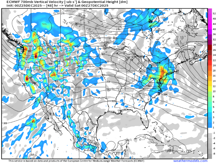
-
26th-27th event, coming at us like a wounded duck.
Ginx snewx replied to Go Kart Mozart's topic in New England
Sure but snow at 54.png.8e7e03d7409ab3d6c47b7947ba4e318c.png)
-
Snow will be gone 2 days later so people need to chill
-
Most of my property torched off yesterday but it's full cover across the street so if I squint when I look out the window it's a white Christmas.
-

2025-2026 Fall/Winter Mountain Thread
franklin NCwx replied to Buckethead's topic in Southeastern States
Merry Christmas -

26th-27th event, coming at us like a wounded duck.
mob1 replied to Go Kart Mozart's topic in New England
Can you please post one frame before this (39)? -
And today just stop with the bickering. Just stop. Go enjoy time with your families/friends if you can’t help yourself here today.
-
I'm interested to see Bobby Martrichs' from EPAWA last call text message alert. I go with his forecast for my area. He's good. No BS stuff.
-
Tough forecast for sure for New Brunswick along I-78 then south to Trenton. I’d go with maybe a few inches there but expect that sleet could cut into it quite a bit. Like others have said the sleet usually ends up north of where it’s supposed to and sometimes by quite a bit. But if it comes on like a real thump then maybe the colder models could be closer to right since a lot of snow will fall before warm air aloft can ruin it. You can almost always count on the late north shifts on these type of storms unless a strong block can stop it. Anyway-try to enjoy whatever happens and Merry Christmas/happy holidays.
-

26th-27th event, coming at us like a wounded duck.
Sey-Mour Snow replied to Go Kart Mozart's topic in New England
Euro back to the 00z look after 6z bumped SW -
26th-27th event, coming at us like a wounded duck.
weatherwiz replied to Go Kart Mozart's topic in New England
Euro may be a bit more northeast too...tough to tell but regardless looks pretty solid for much of CT with a quick glance


.png.3be8854bd47a9889f288a678a94ed011.png)


