All Activity
- Past hour
-
Down to 5F so far in the valley in E CT; how quick does the cold air get mixed out?
-
.thumb.jpg.6a4895b2a43f87359e4e7d04a6fa0d14.jpg)
Central PA Spring 2026 Discussion/Obs Thread
Yardstickgozinya replied to Voyager's topic in Upstate New York/Pennsylvania
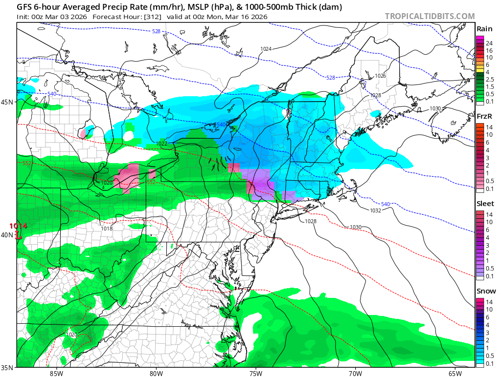
Latest discussion on today's freezing rain from nws. -- Highlight Changed Discussion 619 FXUS61 KCTP 030741 AFDCTP Area Forecast Discussion National Weather Service State College PA 241 AM EST Tue Mar 3 2026 .WHAT HAS CHANGED... * Minor adjustments to hourly temperatures today into tonight && .KEY MESSAGES... 1) Light wintry mix with minor ice accumulation brings slippery road conditions and travel/school delays early today 2) Periods of much-needed rain expected from Wednesday through the first weekend of March; wet pattern favored into next week with above-normal rainfall likely 3) Significant springtime warming pattern ramps up from late week into the second week of March && .DISCUSSION... KEY MESSAGE 1: Light wintry mix with minor ice accumulation brings slippery road conditions and travel/school delays early today A low-level warm advection regime will sustain light wintry precip as it continues to spread from southwest to northeast across CPA this morning. Some sleet and/or light snow may fall at the onset or on the front-end of precipitation as -2 to -6C max wet bulb temps retreat to the northeast. Light/minor ice accumulation from freezing rain of generally 0.10 of an inch or less is likely across the bulk of Central PA with slightly higher amounts possible - particularly on the southwest Allegheny ridges. Temperatures warm above the freezing mark from southwest to northeast through the afternoon into tonight effectively transitioning ptypes to plain rain. Fog and low stratus may be expansive overnight with lingering areas of light rain and pockets of drizzle. - Today
-
Central PA Spring 2026 Discussion/Obs Thread
Yardstickgozinya replied to Voyager's topic in Upstate New York/Pennsylvania
Freezing rain atm. It's definitely getting slick out. The winter weather advisory was a good call. Watch out for morons this morning,and stay safe . -
Central PA Spring 2026 Discussion/Obs Thread
Yardstickgozinya replied to Voyager's topic in Upstate New York/Pennsylvania
Sleet and freezing rain started here at 3:36AM -
Only 14 days away on an operational model! We can do this!!!!!
-

Central PA Spring 2026 Discussion/Obs Thread
MAG5035 replied to Voyager's topic in Upstate New York/Pennsylvania
Freezing rain has arrived here and quickly glazing. 29/27ºF -

Late February/Early March 2026 Mid-Long Range
Stormchaserchuck1 replied to WxUSAF's topic in Mid Atlantic
Models have really come around to a better looking Pacific.. -
Outta gas and Outta Time: Early March Winter Storm finale
Stormchaserchuck1 replied to Ji's topic in Mid Atlantic
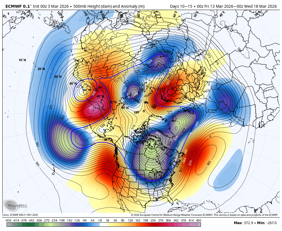
Yeah, but this is the 500mb pattern, super unfavorable on large scale as a sustained thing, it's taking a few days to change the surface. -
2026-2027 El Nino
Stormchaserchuck1 replied to Stormchaserchuck1's topic in Weather Forecasting and Discussion
Thank you donsutherland for Phoenix, AZ statistics.. this was their warmest Winter on record by a lot. The difference between 1 and 2 is almost the same as 2 and 20. Climate analog point - the pattern that follows April-June of the analogs is below, notice the -H5 up north and -PNA in the Pacific. I've seen this when DC hits a record Winter high temperature or some other US city, the Polar area gets negative anomaly, and there is more ridging at the mid-latitudes +months forward: April US Temps (+2-4 months, some progression east) -
-

Late February/Early March 2026 Mid-Long Range
Weather Will replied to WxUSAF's topic in Mid Atlantic
WB 0Z EURO gives us two waves of digital snow to watch. Only 13 days of tracking to go.....


-
Too bad its weenie land
-
30 here
-
Down to 10
-
I remember March 2016 we hit 81 on Mar 9th and then got a 4-6" snowstorm on Mar 21st and 2 more snow/ice storms in early April. It's a wild month.
-
Seasonal snow to date: 14" 12/5: 1.75" 12/14: 1.0" 1/24-25: 8.5" 2/22-23: 2.0" 3/2: 0.75" I think I'm good for at least one more 0.5". Maybe a sloppy car topper on April 11th
-
each and all happy
-
70's-80F to snow - LFG
-
=)
-

-

Central PA Winter 25/26 Discussion and Obs
Ruin replied to MAG5035's topic in Upstate New York/Pennsylvania
I kind of feel it was way colder then this -
Forecast calling for a high of 86 here next Tuesday 3/10. I don't know what the record for that day is in Atl. but I imagine 86 would destroy it if true.
-

Outta gas and Outta Time: Early March Winter Storm finale
SnowenOutThere replied to Ji's topic in Mid Atlantic
Spoiler alert it’s freezing drizzle to my eyes