All Activity
- Past hour
-

2026-2027 Record-breaking El Nino
40/70 Benchmark replied to Stormchaserchuck1's topic in Weather Forecasting and Discussion
I know it sounds cliche, but awful forecasts are the best learning tools....it's all about perspective. You just have to own it and approach with an open mind. -
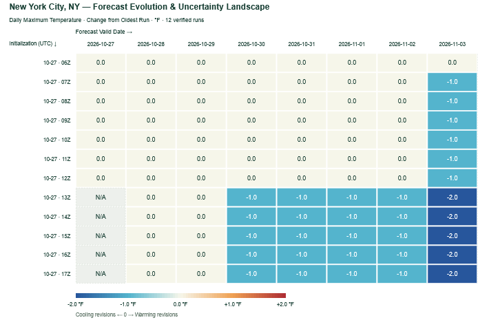
The most recent NBM cycles have grown slightly cooler for the start of November. Nevertheless, readings remain well above average.
-
This October pattern is a near repeat of the one from two years ago when we hit 80°F on Halloween and then again on the 5th of November. I don't know if this will be the warmest October ever, but it will likely have the most >60°F days with all but one day exceeding that high. The 17th ruined a possible perfect score with a high of 53°F. La Nina vs. El Nino doesn't seem to make a difference there. Welcome to extended summer.
-

2026-2027 Record-breaking El Nino
OSUmetstud replied to Stormchaserchuck1's topic in Weather Forecasting and Discussion
Cohen man idk. That dude is always forecasting big snow lols. -

2026-2027 Record-breaking El Nino
forkyfork replied to Stormchaserchuck1's topic in Weather Forecasting and Discussion
weenied for being right -

2026-2027 Record-breaking El Nino
Typhoon Tip replied to Stormchaserchuck1's topic in Weather Forecasting and Discussion
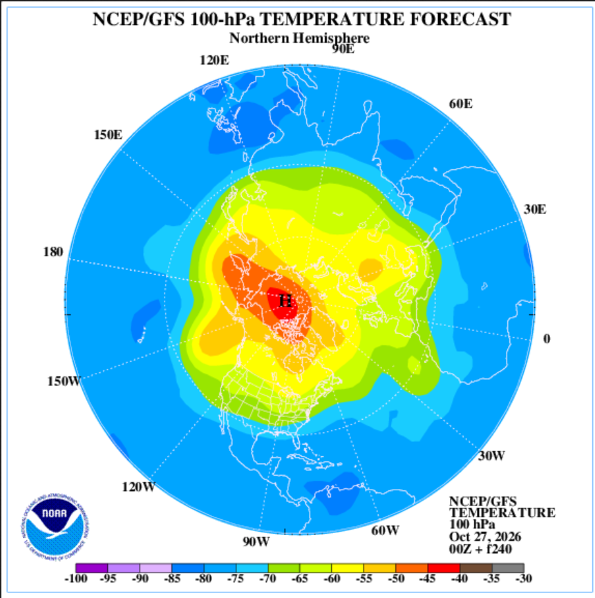
Don't have much time today; just wanna get this out there before I forgotted, as my niece would say- This is likely to physically stress the PV, below. It's the 100 hPa level thermal anomaly centered on D10 off 00z last night, over at the strat-trop monitoring office. Said stressing would likely respond a -AO index as we age on thru the first week of November. This may be what the background soc-media chorus is singing about? Not sure, but this did not have an origin from an SSW event. Just so's that's noted. as I was mentioning to Ray yesterday, it won't make much difference. Timing perhaps. But whether there's an SSW --> -AO (after 20 day lag) or something going on from bottom --> up ( which this appears to be...), there is likely to be a -AO response of some kind in either case. SO, I'm not hugely put off by anyone that thinks it's SSW but just sayn' That's impressive there tho... It's actually in place already as of the initialization last night, but is amplifying out in time. I checked the rotated PCP analysis version and the AO is in fact crashing to about -.5 by Novie 7 or so. The same source - btw- also depicts the PNA rising to an impressive +1.5 to almost 2 SD... We'll see where the hemispheric conveyors set up on the AO stuff but that PNA is a mode change.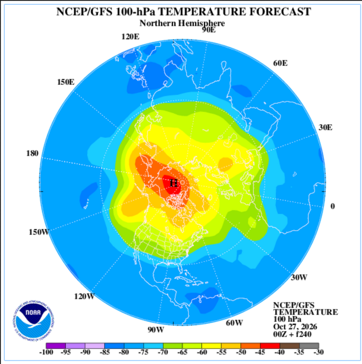
-
People start looking for winter earlier every year…and when it doesn’t show up in late October, well winter gets cancelled.
-

2026-2027 Record-breaking El Nino
Keith Central PA replied to Stormchaserchuck1's topic in Weather Forecasting and Discussion
weak Nino's turn out to be the best for us like 09-10,77-78,..also weak Nina's after strong Nino's..like 66-67. Maybe next winter. -
In Methuen people are taking wood pallets from business parking lots....
-

2026-2027 Record-breaking El Nino
MJO812 replied to Stormchaserchuck1's topic in Weather Forecasting and Discussion
You need a break -
2026-2027 Record-breaking El Nino
MJO812 replied to Stormchaserchuck1's topic in Weather Forecasting and Discussion
Not going to be like that winter unless very strong blocking happens. -

2026-2027 Record-breaking El Nino
A-L-E-K replied to Stormchaserchuck1's topic in Weather Forecasting and Discussion
here for it obviously these are heady times for those of us into anomalous wx of all types -
saturday halloween with these temps, look out
-
2026-2027 Record-breaking El Nino
forkyfork replied to Stormchaserchuck1's topic in Weather Forecasting and Discussion
poor thing -
2026-2027 Record-breaking El Nino
Keith Central PA replied to Stormchaserchuck1's topic in Weather Forecasting and Discussion
09-10 had a cold December and a snowstorm on December 19th..That's not happening this year, wish it would, sorry -
Where’s 70 today? ….55 here today. Maybe Friday though. And You say the same stuff each October Brett. Last October you were so down on the upcoming winter too ….then you got two 2 footers plus. lol.
-

-
Judah Cohen blog https://published.aer.com/aoblog/aoblog.html Plain Language Summary The widespread warmth across the Northern Hemisphere (NH) this past summer and now the fall has continued into October (see Figure). However, a series of stretched polar vortex (PV) this month has led to some, albeit modest cooling in Siberia, East Asia and to an even lesser extent far Eastern Canada and New England (see Figure). However, one last stretched PV will bring more intense cooling to Siberia and East Asia and yet again more modest cooling to far eastern Canada and New England (see Figures 3 and 6). Some blocking in the North Atlantic and near Scandinavia will also bring colder temperatures to Europe (see Figure 9). But all eyes then turn to a much larger disruption of the PV that is likely to have an important influence on NH weather late November into December.
-
2026-2027 Record-breaking El Nino
MJO812 replied to Stormchaserchuck1's topic in Weather Forecasting and Discussion
He already busted last winter. -
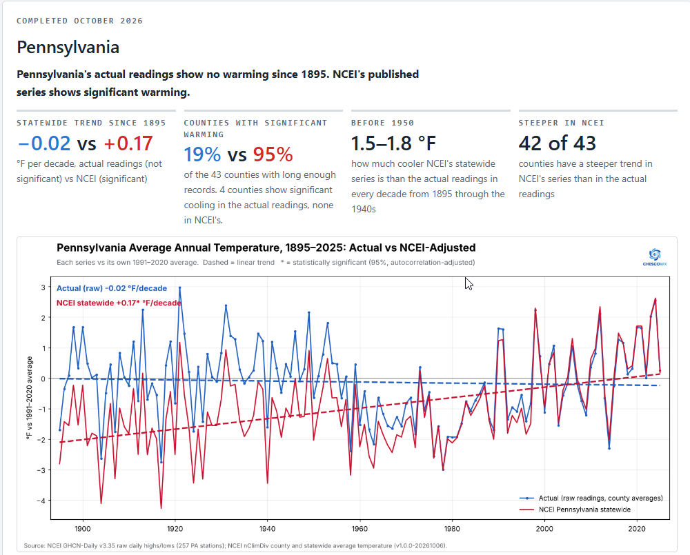
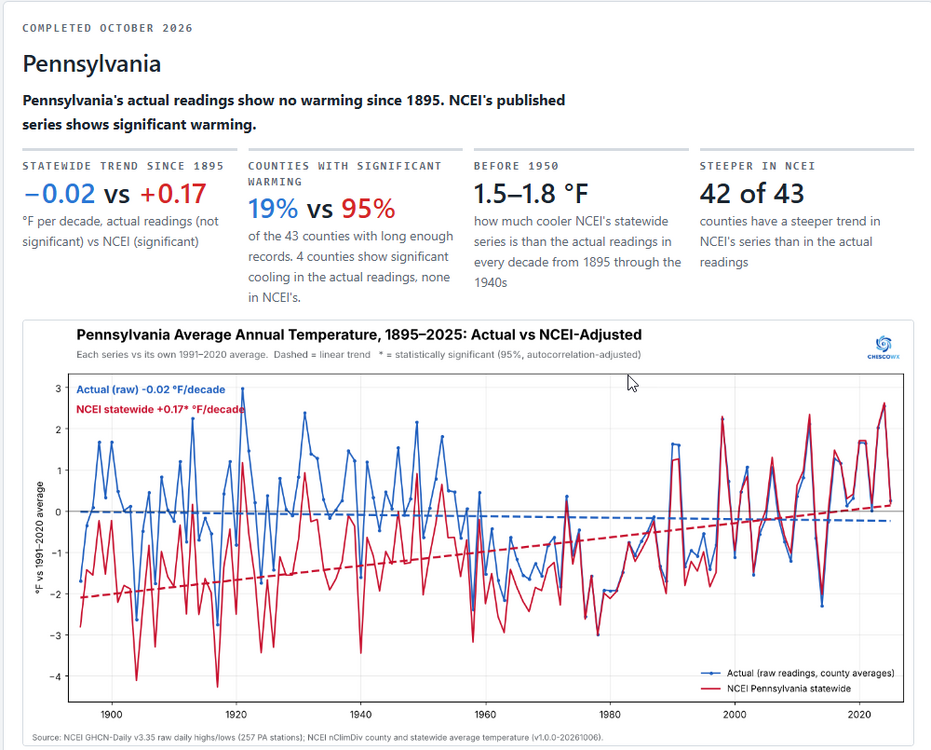
 Our first state of the Nationwide Study is now complete. First up is the state of Pennsylvania. We will release one state per day over the next 47 days. For much more detail including study design, by decade breakdowns, county by county maps and breakdowns for all State Counties that compare actual vs NCEI trends for each state please go to https://chescowx.com/raw-vs-ncei-state-by-state/ If interested in seeing your state next up on the list please let me know and we will do our best to release that state within 2 days. Thanks again! The main finding for Pennsylvania is the actual readings show no warming at all since 1895! NCEI's published series shows significant warming. Averaging what Pennsylvania's observers actually recorded, county by county and weighted by county area, gives a flat statewide trend from 1895 to 2025 (-0.02 °F per decade, not significant). NCEI's published statewide series warms +0.17 °F per decade, about 2.2 °F in total. The two diverge at +0.19 °F per decade (p < 0.001). NCEI's series runs 1.5–1.8 °F below the actual readings in every decade from 1895 through the 1940s, about 1.0 °F below in the 1950s and 0.7 °F in the 1960s. It is within about 0.35 °F from the 1970s on. The short version NCEI's 67 counties add up to its statewide series. Weighting NCEI's county values by area reproduces its Pennsylvania statewide series within 0.03 °F in every year. Building the state from counties is therefore a like-for-like comparison. The actual readings show no significant statewide trend. They give -0.02 °F/decade (95% range -0.10 to +0.06). NCEI's series gives +0.17 (range +0.10 to +0.24). The ranges do not overlap. The two trend lines are significantly different. The gap between NCEI's statewide series and the actual readings grows at +0.19 °F per decade (95% range +0.15 to +0.22, p < 0.001), so NCEI's adjustments add a statistically significant amount of warming. County by county, NCEI's adjustments add significant warming to the trend in 25 of 43 counties (58%) and significant cooling in 0. NCEI cools the early record in nearly every county. From 1895 through the 1940s, NCEI's county series is cooler than the actual readings in 90–100% of counties in each decade, by a median of about −0.9 to −1.7 °F. The share is 77–81% in the 1950s–70s, about 53% in the 1980s and 1990s, and about 31–33% after 2000. Recent decades match. From 2000 on, the median county difference is about 0.0 °F. NCEI is cooler than the actual readings in 32% of county-decades and warmer in 41%. County verdicts flip toward warming. 43 counties have long enough raw records for a trend. In the actual readings, 8 (19%) show significant warming, 31 (72%) no significant trend, and 4 (9%) significant cooling. In NCEI's county series, 41 (95%) show significant warming and none show cooling. NCEI's trend is steeper in 42 of 43 counties; Philadelphia is the only exception. The 1930s lose their warmth. In the actual readings the 1930s average +0.9 °F against the 1991–2020 normal, the warmest decade before the 2020s. NCEI puts the 1930s at -0.7 °F. Chester County fits the pattern. The actual readings from Chester County's GHCN-Daily stations give -0.01 °F/decade (not significant), against +0.24 °F/decade (significant) for NCEI's Chester County series over the same years.
-

2026-2027 Record-breaking El Nino
Cobalt replied to Stormchaserchuck1's topic in Weather Forecasting and Discussion
I wonder if he wished for a super nino for the big 40th, or maybe some humility
-
Silly people like Brett already have the winter over in October lmfao… so pathetic!
-
2026-2027 Record-breaking El Nino
forkyfork replied to Stormchaserchuck1's topic in Weather Forecasting and Discussion
nope -
2026-2027 Record-breaking El Nino
40/70 Benchmark replied to Stormchaserchuck1's topic in Weather Forecasting and Discussion
@forkyforkMy mistake concerning underselling ENSO early on was being focused too much on periodicity given the magnitude of the 2023 event just 3 years ago, but upon gaining a more through appreciation for the impact that the solar cycle on ENSO, I now realize that it was 2023 that was the anomaly given that it occurred near solar max. This event is occurring right in the descending solar wheelhouse. My guess is the magnitude of 2023 was largely the result of CC in that it represented a failed effort to redistribute that warm pool eastward...if at first you don't succeed.... -
 I still think one or possibly two events could workout later in February with a second ssw. Even 72/73 which was horrendous in NYC had a big one in the southern mid Atlantic. So there is definitely precedent. I think we get hung up on 97/98 too much. That winter everything just went wrong. .