All Activity
- Past hour
-
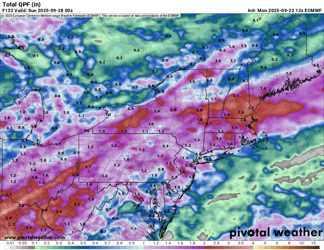
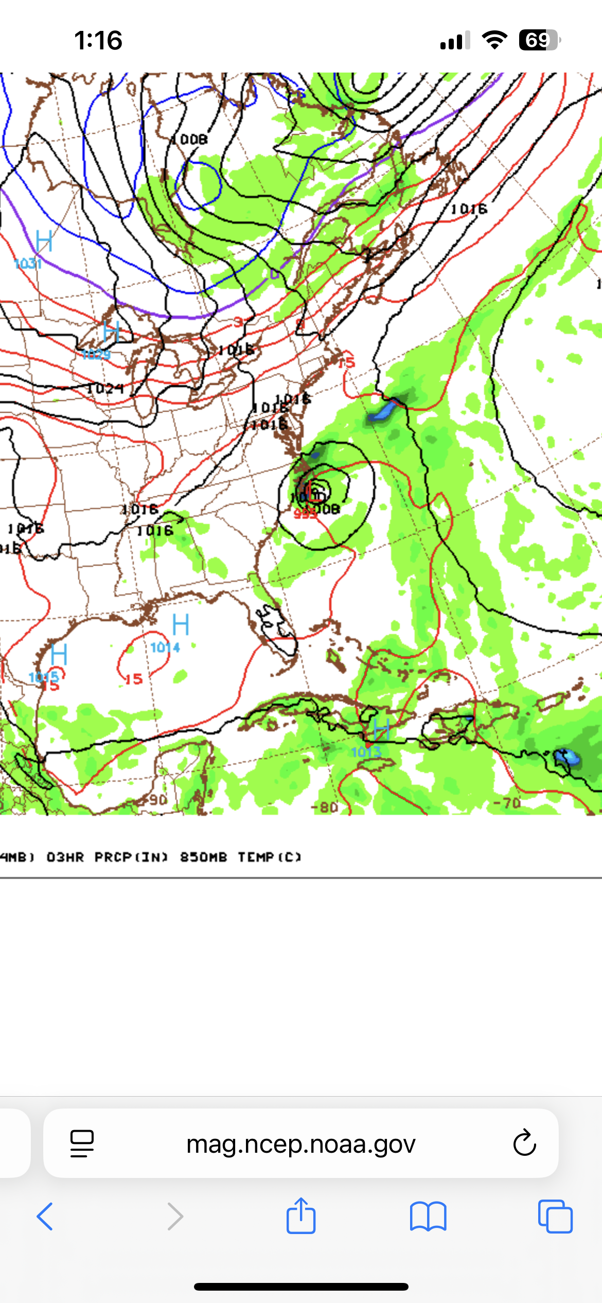
 The brand new (12Z) Euro has this on 9/29 hit NC as a TD.
 -
We pray for the euro

-

September 2025 General Discussion
SchaumburgStormer replied to Geoboy645's topic in Lakes/Ohio Valley
You know winter is coming when we start getting the Spartman Tennessee focused precip maps. -
I'm going to be real honest, we're trying to pour concrete for more mesonet sites and we just need some windows of dry weather.
-
 Pushes it south after this if I’m looking at the right one. We could use the rain, but please not another Florence.
 -
Euro really has the mix line hugging I-95 though
-
well then you will not have to worry about...Plenty of side street sweat this winter with cutters.
-
Not many when you work during the only hours where it's light. That's why we summer.
-
if that doesn't pan out i'll be pulling my boat out next weekend, I've never seen the CT river lower than it is right nowelles StGlastonbury, CT 06033
-
How much of that is snow?
-
Dude I already asked for 26-28, I guess we can add in two more days . Looking at GFS/Euro, seems like something comes through thurs/fri and sat/sun appear dry? GFS was bringing some sort of storm up the coast but now its delayed and not as close to land.
-
12Z GEFS: another pretty active run
-
on a typical winter day how many hours do you spend outdoors??
-
Hour 177 is interesting. 6z GFS had the storm much closer to the DC area but still something to watch.
-
Detroit played well last week on the offensive side of the ball, but Goff seems to have problems with outdoor games. Maybe tonight is one of those problem nights.
-
It was 45F here for a low last night, now 69F. Nice day!
-
It’s going to remain all over the place for a bit. A lot of uncertainty with this one with the upper level pattern the opposite of this at 00z on the Euro. But for up here we want to see that trough migrate from the SE to the GL region in future runs with far less troughing to our north lol.
-
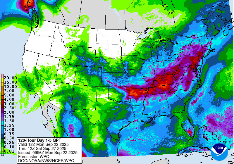
I like the HPC QPF five-day precip forecast, as it now stands. More rain than I have seen (Brattleboro or here) in like months? Seems like years...
-
I’m so ready to just see a huge precip shield on radar
-
Saturday for overseeding here. Hopefully the rain does come as expected starting tomorrow.
-
 This one could very well end up further west than Gabrielle. Would definitely watch in Bermuda. I expect the odds to go up at 2pm. It still has disorganized convection but it looks like it’s trying to consolidate.
 -
The confluence is way different than earlier runs
- Today
-
Yeah as long as you have that flow over New England this one won’t get here. Could still do something further south though.
-
Plenty of side street sweat this winter with cutters.
-
The 12Z UKMET threatens Bermuda: NEW TROPICAL CYCLONE FORECAST TO DEVELOP AFTER 90 HOURS FORECAST POSITION AT T+ 90 : 22.0N 61.0W LEAD CENTRAL MAXIMUM WIND VERIFYING TIME TIME POSITION PRESSURE (MB) SPEED (KNOTS) -------------- ---- -------- ------------- ------------- 1200UTC 26.09.2025 96 22.5N 61.5W 1010 35 0000UTC 27.09.2025 108 22.5N 62.5W 1008 37 1200UTC 27.09.2025 120 23.1N 63.5W 1007 38 0000UTC 28.09.2025 132 23.7N 64.1W 1005 45 1200UTC 28.09.2025 144 24.5N 66.1W 1003 41 0000UTC 29.09.2025 156 25.6N 66.8W 1000 43 1200UTC 29.09.2025 168 27.2N 66.4W 997 45