All Activity
- Past hour
-
Weathernet further west 18z vs 0z
-
.thumb.jpg.6a4895b2a43f87359e4e7d04a6fa0d14.jpg)
Central PA Winter 25/26 Discussion and Obs
Yardstickgozinya replied to MAG5035's topic in Upstate New York/Pennsylvania
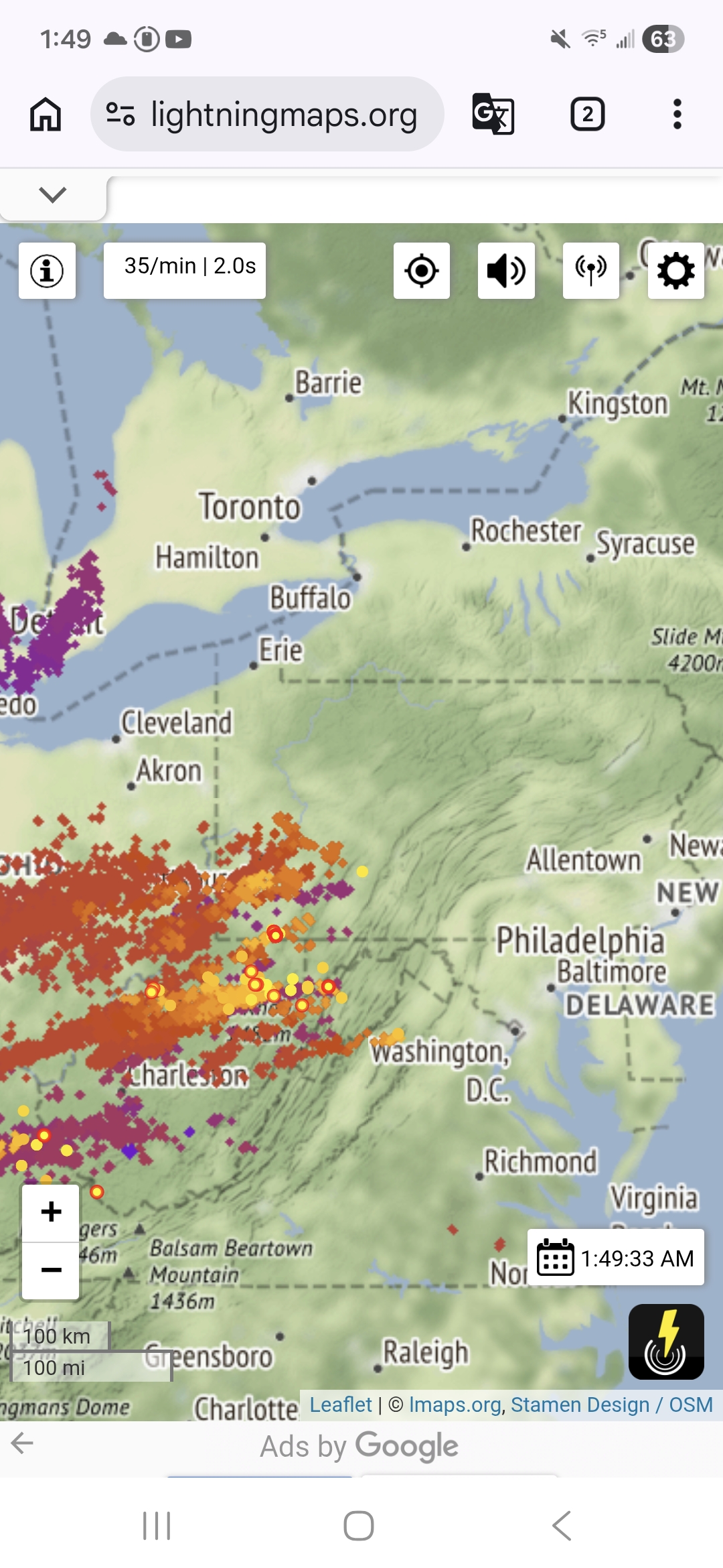
There's still a pretty decent amount of convection and lightning for this hour, that looks like it will make it into West Central Pa. at the very least.
-

Feb 22nd/23rd "There's no way..." Storm Thread
BristowWx replied to Maestrobjwa's topic in Mid Atlantic
I could have cashed out at folks jackpot 8 pages back and went to sleep…but I had to keep playing and order bnachos…I swear this hobby is just like the casino -
I have certainly enjoyed the last four days of heavy snow in the Sierras. I have gotten quite the FIX. However, no mercy. We get 4 days off, then Tuesday another three feet of very heavy WET snow descend on Mammoth. Skiers will get their fill of the white room tomorrow. Main Lodge lifts will be up and spinning by 10am local Pac time. SIX FEET of fresh POW await those who get there first. Palisades Tahoe got EIGHT FEET of fresh POW! Skiers are gonnabe besides themselves with pure JOY! Every time I close my eyes all I see are huge aggregates being driven by 85 mph gusts at Mammoth! All I see is Plow Guy plowing DEEP snow! https://www.mammothmountain.com/on-the-mountain/mammoth-webcam/main-lodge Check out this 6 FOOT DRIFT on the 8200 foot Scope at Palisades!!!! https://www.palisadestahoe.com/mountain-information/webcams See also Alpine Lodge https://www.palisadestahoe.com/mountain-information/webcams#tab=alpine https://blog.palisadestahoe.com/weather/8-feet-with-a-final-foot-thursday/ https://blog.palisadestahoe.com/operations/feb-18-operations-update/ https://blog.palisadestahoe.com/operations/feb-19-operations-update/
-
WSW expanded up here.
-

Feb 22nd/23rd "There's no way..." Storm Thread
clskinsfan replied to Maestrobjwa's topic in Mid Atlantic
Nothing says the Jack will be west at all. Bermuda will be the jack soon. -
The GFS is a embarrassment to this country
- Today
-

Feb 22nd/23rd "There's no way..." Storm Thread
ravensrule replied to Maestrobjwa's topic in Mid Atlantic

-

Feb 22nd/23rd "There's no way..." Storm Thread
balltermen replied to Maestrobjwa's topic in Mid Atlantic
I think the jack might be a bit further west at elevation. Thurmont maybe -

Feb 22nd/23rd "There's no way..." Storm Thread
rjvanals replied to Maestrobjwa's topic in Mid Atlantic
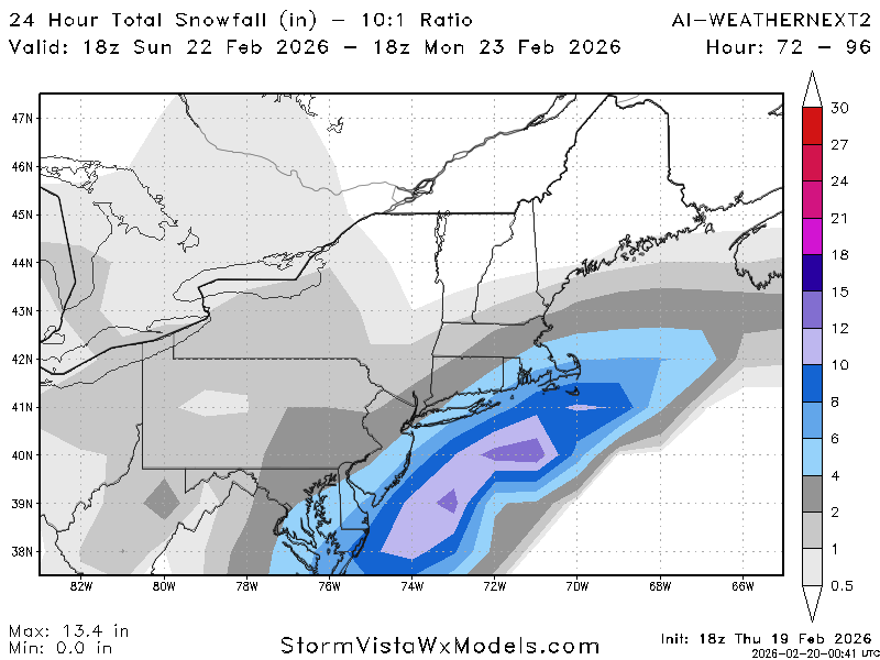
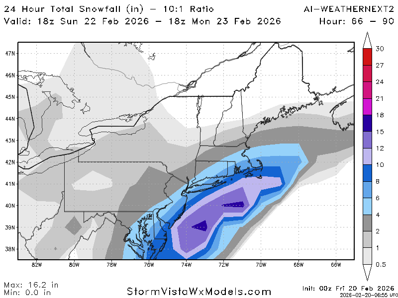
12z Euro ensembles are a bit east but most give us some snow but no real high end potential -
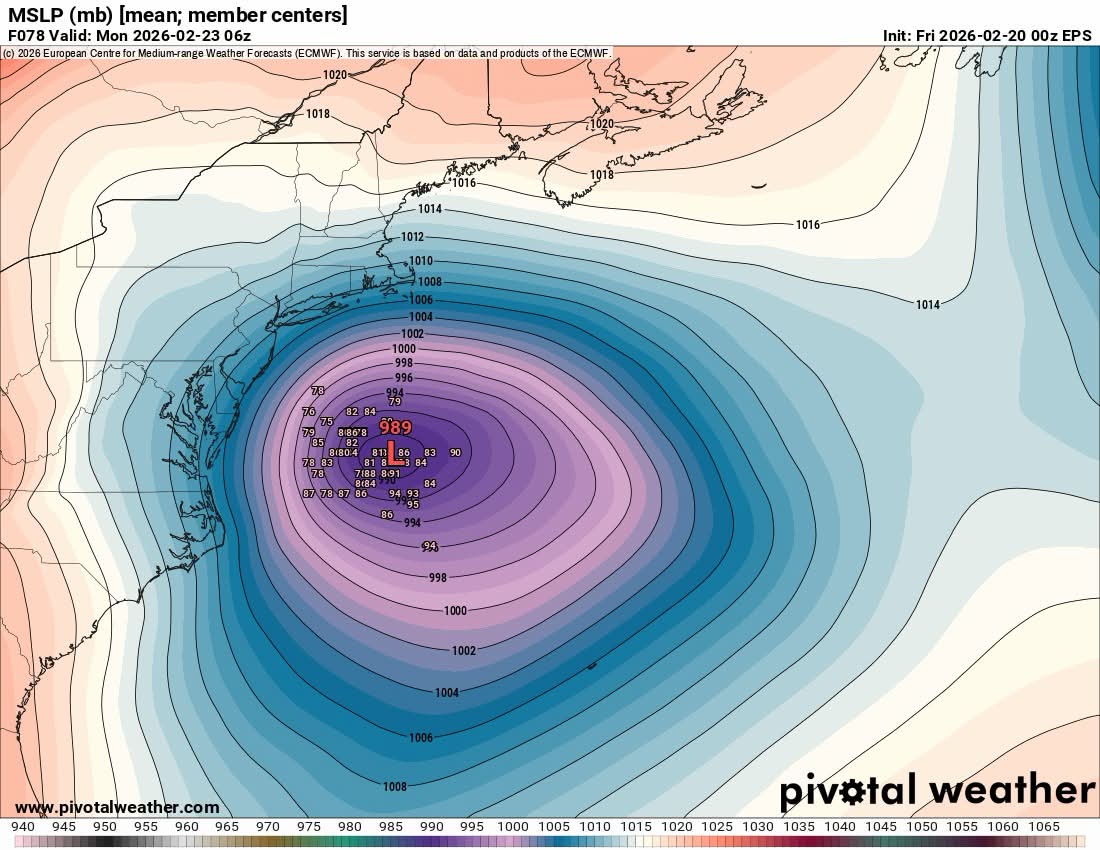
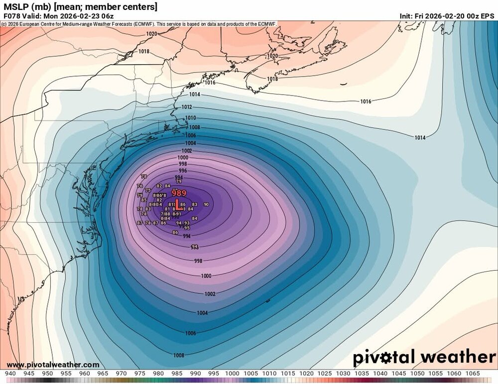
Eps
-
Feb 22nd/23rd "There's no way..." Storm Thread
balltermen replied to Maestrobjwa's topic in Mid Atlantic
GFS is so bad with this kind of setup. The model isn't designed for East coast snowstorms and unfortunately it sucks at them. I'm sure it may be superior in a bunch of areas. Not this. -
Feb 22nd/23rd "There's no way..." Storm Thread
ravensrule replied to Maestrobjwa's topic in Mid Atlantic
He is soooo annoying. -

Feb 22nd/23rd "There's no way..." Storm Thread
DDweatherman replied to Maestrobjwa's topic in Mid Atlantic
Stay in the Richmond, VA “anals” please -
Feb 22nd/23rd "There's no way..." Storm Thread
rjvanals replied to Maestrobjwa's topic in Mid Atlantic
The GFS is now in NAM at 84 hr territory -
Whelp, I’m out for tonight, good to see the other models come more towards the GFS than vice-versa tonight. Hopefully that trend continues tomorrow with a little more latitude thrown the GFS’ way
-
Feb 22nd/23rd "There's no way..." Storm Thread
balltermen replied to Maestrobjwa's topic in Mid Atlantic
1) Knickerbocker 2) 2/23/26 3) 1899 4) PD1 -
For a model with an over amplified bias it’s been a huge letdown
-
I also lost 18 inches from 12z on the GFS should I never log back on
-
Feb 22nd/23rd "There's no way..." Storm Thread
balltermen replied to Maestrobjwa's topic in Mid Atlantic
I think you'll score. but maybe 3-6" instead of the largest snowstorm on record at DCA that the GFS depicts. -
Feb 22nd/23rd "There's no way..." Storm Thread
clskinsfan replied to Maestrobjwa's topic in Mid Atlantic
Not really. It has been consistently a fail for us. And it makes sense at the upper levels. -
-
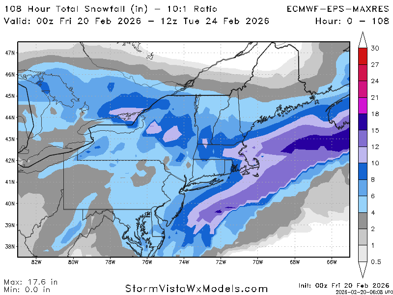
The initial wave isn’t from the IVT, it’s from the interaction of the northern and southern streams. The IVT only comes into play once the low starts to head well east. It actually mostly misses us on this run and slams York/Lancaster.
-
Feb 22nd/23rd "There's no way..." Storm Thread
clskinsfan replied to Maestrobjwa's topic in Mid Atlantic
He's not even looking at the GFS when it comes to climo though. It is so far out of what everything else is saying. -
So euro was extremely disappointing