All Activity
- Past hour
-

September 2025 OBS-Discussion centered NYC subforum
WestBabylonWeather replied to wdrag's topic in New York City Metro
Sitting on the deck right now like it’s July -

September 2025 OBS-Discussion centered NYC subforum
donsutherland1 replied to wdrag's topic in New York City Metro
It was. Islip also tied its daily record of 85° from 1970. -
September 2025 OBS-Discussion centered NYC subforum
donsutherland1 replied to wdrag's topic in New York City Metro
Rainfall amounts in the New York City area were generally less than the 0.50"-1.50" forecast amounts. There was a stripe of heavier rainfall in parts of Connecticut. Storm total amounts included: Hartford: 1.72" Islip: 0.30" New Haven: 1.34" New York City-Central Park: 0.35" New York City-JFK Airport: 1.38" New York City-LaGuardia Airport: 0.33" Newark: 0.17" Storrs: 2.76" White Plains: 0.47" As a result, New York City is on track to finish with rainfall that is below the 4.31" monthly normal value for September. Almost as if to add insult to injury to the dry New York City area, in the past hour, Phoenix has picked up 1.09" of rain, along with winds gusting to 56 mph. The 1.11" so far today is its biggest rainstorm since October 13, 2018. Above normal temperatures will continue through the remainder of September. Another round of showers is possible Saturday night into Sunday. A significant rainfall is unlikely. The guidance and historical experience following a second half September mean temperature of 70° or above suggest that October will be warmer than normal in the New York City area. The two most recent Octobers with a cooler than normal first half like 2025 and a second half with a mean temperature of 70° or above were: 2017 (October mean temperature: 64.1° and October 2019: October mean temperature 59.9°). The extent of ridging to the north and interaction between the Humberto and Invest. 94 could ultimately determine whether Invest. 94 poses an eventual threat to a portion of the Southeast or stays out to sea. The potential Fujiwhara interaction would be unusual for the Atlantic basin. Typically, if the stronger system is to the right or east of the weaker one (possibly Invest. 94 as per most of the guidance at present), the stronger system will tend to deflect the weaker one northward and eastward sooner than might otherwise be the case. If both systems are of similar strength, they can rotate counterclockwise around a midpoint roughly between the centers of the two storms as they move along the steering flow. Two plausible scenarios are landfall along the South Carolina coast or a sharp turn out to sea after an approach toward the coastline. For now, tropics bear watching for the Southeast. The ENSO Region 1+2 anomaly was 0.0°C and the Region 3.4 anomaly was -0.4°C for the week centered around September 17. For the past six weeks, the ENSO Region 1+2 anomaly has averaged -0.03°C and the ENSO Region 3.4 anomaly has averaged -0.38°C. La Niña conditions will likely develop during mid- or late-autumn. The SOI was +9.81 today. The preliminary Arctic Oscillation (AO) was +1.341 today. Based on sensitivity analysis applied to the latest guidance, there is an implied near 86% probability that New York City will have a warmer than normal September (1991-2020 normal). September will likely finish with a mean temperature near 70.1° (0.9° above normal). Supplemental Information: The projected mean would be 2.1° above the 1981-2010 normal monthly value. -
Happening rn in Lancaster NH

-

Potential Tropical Cyclone Nine
Coach McGuirk replied to WxWatcher007's topic in Tropical Headquarters
This could be a dud or something huge or in-between. I think it will rapidly form into a cat 3 but we shall see. -
Yeah that didn't go over well-given how shitty the D has played he was the wrong messenger and at the wrong time.
-
Just saw that Gabrielle added 19 ACE compared to Erin's 32.2. Does anyone know what to expect from Humberto?
-
NHC
-

Potential Tropical Cyclone Nine
Wannabehippie replied to WxWatcher007's topic in Tropical Headquarters
So far wind shear still an issue. -
It seems we are approaching peak here… agree, Columbus Day is going to be well past peak. I tell people every year come early but nobody listen. Much rather pay premium price on Columbus Day to see those sticks than lower rates and smaller crowds a week or two earlier when foliage is still ON the trees !
-
-

Potential Tropical Cyclone Nine
olafminesaw replied to WxWatcher007's topic in Tropical Headquarters
Models haven't really been showing meaningful organization for another 24 hours or so, so we appear to be on track -
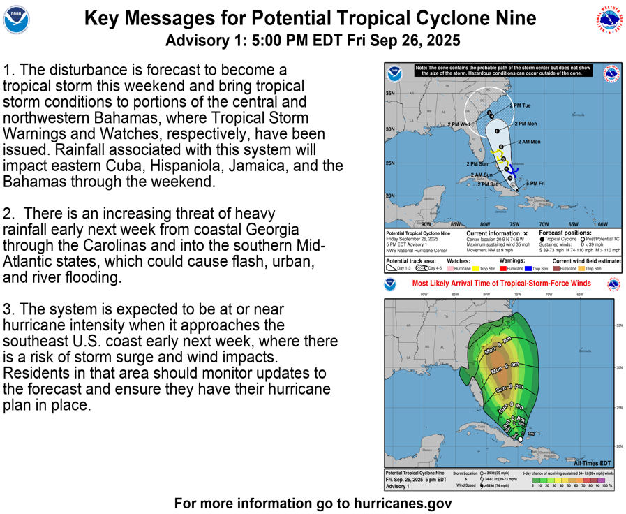
Potential Tropical Cyclone Nine Discussion Number 1 NWS National Hurricane Center Miami FL AL092025 500 PM EDT Fri Sep 26 2025 Visible satellite images and surface observations suggest that Invest 94L is gradually organizing and beginning to develop a low-level circulation near eastern Cuba with estimated maximum winds of about 30 kt. Although the system does not meet the criteria of a tropical cyclone currently, it is expected to become one during the next day or so. In addition, the system is likely to bring tropical storm conditions to portions of the central and northwestern Bahamas this weekend and potential impacts to portions of the southeast U.S. early next week. Therefore, NHC is now initiating Potential Tropical Cyclone advisories for this disturbance. The system has been moving west-northwestward at about 8 kt during the past 12 to 24 hours. However, this motion is expected to change as the disturbance is forecast to turn northward in southerly flow between a large-scale trough over the eastern U.S. and a subtropical ridge over the central-western Atlantic. This track should take the system across the central and northwestern Bahamas over the weekend. The models are in good agreement through that time period, but they diverge significantly early next week when the synoptic pattern becomes complicated. If the system moves on the fast side of the guidance, it will likely be more influenced by the U.S. trough that is expected to cut off. In that scenario, the disturbance would move inland over the southeast U.S. early next week. Conversely, if the system moves on the slow side of the guidance, Humberto's circulation will cause the steering currents to collapse, resulting in this system stalling near the southeast coast or drifting eastward. The NHC track forecast lies roughly between these scenarios, in best agreement with EMXI, but confidence is very low in the days 4 and 5 positions. Strengthening is likely to be slow in the short term due to the current land interaction and some southerly shear. However, gradual intensification seems like a good bet this weekend and on Monday while the system tracks over the Gulf Stream and within a diffluent upper-level wind pattern. The NHC intensity forecast lies close to the hurricane regional and consensus models and shows the system reaching hurricane strength early next week. It should be emphasized that the long-range intensity forecast depends largely on where the system is and the degree of land interaction at those periods, and therefore, is of low confidence. Given the higher-than-usual uncertainty in the forecast track and intensity of the system, NOAA Hurricane Hunter aircraft have been collecting data over the western Atlantic since yesterday, and additional upper-air launches are occurring. This data collection will continue through the weekend to help improve the model guidance for this system. KEY MESSAGES: 1. The disturbance is forecast to become a tropical storm this weekend and bring tropical storm conditions to portions of the central and northwestern Bahamas, where Tropical Storm Warnings and Watches, respectively, have been issued. Rainfall associated with this system will impact eastern Cuba, Hispaniola, Jamaica, and the Bahamas through the weekend. 2. There is an increasing threat of heavy rainfall early next week from coastal Georgia through the Carolinas and into the southern Mid-Atlantic states, which could cause flash, urban, and river flooding. 3. The system is expected to be at or near hurricane intensity when it approaches the southeast U.S. coast early next week, where there is a risk of storm surge and wind impacts. Residents in that area should monitor updates to the forecast and ensure they have their hurricane plan in place. FORECAST POSITIONS AND MAX WINDS INIT 26/2100Z 20.9N 74.6W 30 KT 35 MPH...POTENTIAL TROP CYCLONE 12H 27/0600Z 21.7N 75.3W 30 KT 35 MPH...POTENTIAL TROP CYCLONE 24H 27/1800Z 22.7N 75.8W 30 KT 35 MPH...TROPICAL CYCLONE 36H 28/0600Z 24.1N 76.4W 35 KT 40 MPH 48H 28/1800Z 25.6N 76.9W 45 KT 50 MPH 60H 29/0600Z 27.4N 77.3W 55 KT 65 MPH 72H 29/1800Z 29.7N 78.0W 65 KT 75 MPH 96H 30/1800Z 31.8N 78.9W 65 KT 75 MPH 120H 01/1800Z 32.3N 79.3W 60 KT 70 MPH $$ Forecaster Cangialosi
-
Potential Tropical Cyclone Nine
Wannabehippie replied to WxWatcher007's topic in Tropical Headquarters
Still looks like a mess on recent still color enhanced satellite photos. No closed center that I see. -
BULLETIN Potential Tropical Cyclone Nine Advisory Number 1 NWS National Hurricane Center Miami FL AL092025 500 PM EDT Fri Sep 26 2025 ...TROPICAL STORM WATCHES AND WARNINGS ISSUED FOR PORTIONS OF THE BAHAMAS... SUMMARY OF 500 PM EDT...2100 UTC...INFORMATION ---------------------------------------------- LOCATION...20.9N 74.6W ABOUT 55 MI...90 KM NNW OF THE EASTERN TIP OF CUBA ABOUT 200 MI...325 KM SSE OF THE CENTRAL BAHAMAS MAXIMUM SUSTAINED WINDS...35 MPH...55 KM/H PRESENT MOVEMENT...NW OR 305 DEGREES AT 9 MPH...15 KM/H MINIMUM CENTRAL PRESSURE...1008 MB...29.77 INCHES WATCHES AND WARNINGS -------------------- CHANGES WITH THIS ADVISORY: The government of the Bahamas has issued a Tropical Storm Warning for the central Bahamas and a Tropical Storm Watch for portions of the northwestern Bahamas. SUMMARY OF WATCHES AND WARNINGS IN EFFECT: A Tropical Storm Warning is in effect for... * Central Bahamas, including Cat Island, the Exumas, Long Island, Rum Cay, and San Salvador. A Tropical Storm Watch is in effect for... * Portions of the northwestern Bahamas, including Eleuthera, New Providence, the Abacos, Berry Islands, and Grand Bahama Island. A Tropical Storm Warning means that tropical storm conditions are expected somewhere within the warning area, within 36 hours. A Tropical Storm Watch means that tropical storm conditions are possible within the watch area, generally within 48 hours. For storm information specific to your area, please monitor products issued by your national meteorological service. Interests in eastern Cuba, the southeast Bahamas, the Turks and Caicos Islands, and the southeastern U.S. should monitor the progress of this system. DISCUSSION AND OUTLOOK ---------------------- At 500 PM EDT (2100 UTC), the disturbance was centered near latitude 20.9 North, longitude 74.6 West. The system is moving toward the northwest near 9 mph (15 km/h). A north-northwestward motion is expected during the next few days. On the forecast track, the center of the system is expected to track across the central and northwestern Bahamas this weekend and approach the southeast U.S. coast early next week. Maximum sustained winds are near 35 mph (55 km/h) with higher gusts. Gradual strengthening is forecast, and the system is expected to become a tropical depression on Saturday and a tropical storm Saturday night or early Sunday. * Formation chance through 48 hours...high...90 percent. * Formation chance through 7 days...high...90 percent. The estimated minimum central pressure based on surface observations is 1008 mb (29.77 inches). HAZARDS AFFECTING LAND ---------------------- Key messages for Potential Tropical Cyclone Nine can be found in the Tropical Cyclone Discussion under AWIPS header MIATCDAT4 and WMO header WTNT44 KNHC. WIND: Tropical storm conditions are expected in the tropical storm warning area beginning Saturday night and are possible in the watch area on Sunday. RAINFALL: The disturbance is expected to produce the following storm total rainfall amounts through Monday morning. Eastern Cuba: 8 to 12 inches, with isolated maximum totals of 16 inches possible. Bahamas: 4 to 8 inches of rain are expected. Hispaniola, Jamaica, and portions of central and southern Cuba: 2 to 4 inches of additional rainfall are expected. This rainfall will likely produce flash and urban flooding. Mudslides are also possible in areas of higher terrain across eastern Cuba, Hispaniola, and Jamaica. An increasing threat of heavy rainfall from this system is forecast over the southern Mid-Atlantic through coastal Georgia which could cause flash, urban, and river flooding into next week. For a complete depiction of forecast rainfall and flash flooding associated with Potential Tropical Cyclone Nine, please see the National Weather Service Storm Total Rainfall Graphic, available at hurricanes.gov/graphics_at4.shtml?rainqpf. STORM SURGE: A storm surge will raise water levels by as much as 1 to 3 feet above ground level along the immediate coast in areas of onshore winds in the northwestern Bahamas. Near the coast, the surge will be accompanied by large waves. SURF: Swells generated by both this system and Hurricane Humberto will affect portions of the Bahamas this weekend, and spread to portions of the southeast U.S. coast early next week. These swells are likely to cause life-threatening surf and rip current conditions. Please consult products from your local weather office. A depiction of rip current risk for the United States can be found at: hurricanes.gov/graphics_at4.shtml?ripCurrents NEXT ADVISORY ------------- Next intermediate advisory at 800 PM EDT. Next complete advisory at 1100 PM EDT. $$ Forecaster Cangialosi
- Today
-
With Humberto rapidly intensifying today, another MH is on the board. Peak Season Forecast (Aug 20-Oct 20) Named Storms: 10 (3) Hurricanes: 6 (2) Major Hurricanes: 3 (2) Fernand, Gabrielle (MH), Humberto (MH)
-

Potential Tropical Cyclone Nine
WxWatcher007 replied to WxWatcher007's topic in Tropical Headquarters
Taking a look at our coming PTC. Thanks to @Nibor for showing me how to post larger gif animations. You can clearly see both the gradual organization and headwinds for the coming PTC 9. To the north, you can see arc clouds still radiating out of the area, indicating the presence of some dry air. You can also see some of the thunderstorm tops being sheared, although it does look like in recent frames that things may have slackened some. It's easier to see the larger scale spin, and recon is on the way to examine how well defined a low level center there is. For a relatively short term forecast, there is still a lot to be figured out. -
Humberto is now a Cat 3. SUMMARY OF 500 PM AST...2100 UTC...INFORMATION ---------------------------------------------- LOCATION...22.3N 58.1W ABOUT 430 MI...690 KM NE OF THE NORTHERN LEEWARD ISLANDS MAXIMUM SUSTAINED WINDS...115 MPH...185 KM/H PRESENT MOVEMENT...WNW OR 295 DEGREES AT 5 MPH...7 KM/H MINIMUM CENTRAL PRESSURE...962 MB...28.41 INCHES
-
NHC will initiate advisories on Potential Tropical Cyclone Nine (formerly AL94), located near eastern Cuba, at 500 PM EDT (2100 UTC).
-
Wonder if he's gonna apologize for the "spoiled" comment, lol (I mean I happen to agree with him but it was really, really bad timing)
-
AI models are interesting for next weekend.. we watch
-
Well I think he was implying that it formed as a result of the event rather than necessarily during it. His name is Paul Roundy and has a lot of neat papers on seasonal climatology fyi. I can ask about the details next class if you want, don't fully know myself tbh.
-
Schools closed Monday in Brunswick County NC (most southern county)
-
colors are really exploding here.. some areas look great.
-
Also can take more precip, refer to Flash Flood Guidance. The terrain causes extra problems..8 inches of rain in NC is very different than Sofla.


.thumb.jpeg.406ecda2eec9e267302c22b9f128fe3c.jpeg)

