All Activity
- Past hour
-

January 2026 Medium/Long Range Discussion
Stormchaserchuck1 replied to snowfan's topic in Mid Atlantic
In January 2024 we got some snow events when the NAO went negative. In stronger El Nino's with a big low pressure in the N. Pacific, a -NAO could be the difference between nothing and a big one. I just don't think we are there with the NAO yet at least consistently, maybe in 5-10 years.. -

Winter 2025-26 Short Range Discussion
michsnowfreak replied to SchaumburgStormer's topic in Lakes/Ohio Valley
2020-21 (48.8" to 44.9"). ORD has only beaten DTW 5 times the last 20 years. -

First Legit Storm Potential of the Season Upon Us
JACKASS replied to 40/70 Benchmark's topic in New England
Posts like a typical trumper. Sad -
Damn man. Hats off to you. I can’t argue with a single thing in this post. And I’m a debate coach.
-

January 2026 Short/Medium Range Thread
Holston_River_Rambler replied to John1122's topic in Tennessee Valley
Looks like they are running two, one tomorrow afternoon / evening (16 20:30 -17 0230z) and one early morning of Saturday (17 830 - . 1430z). But I have no idea if I'm reading that flight plan correctly and can't tell whether they're flying out over the Atlantic or up toward where the vort. is, or both. -
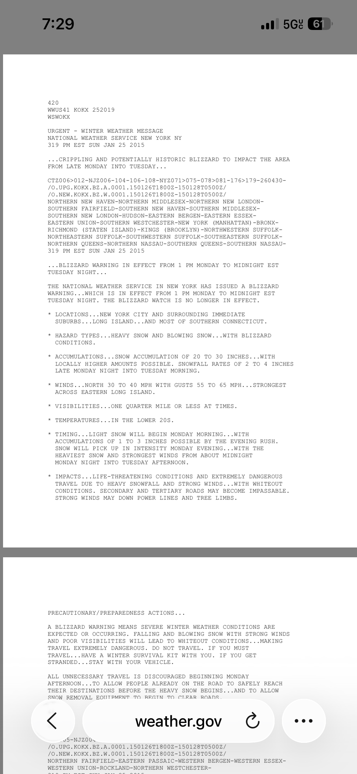
Jan 2015 blizzard warning. Good times
-
BOX did that as well. Musta come from NWS to change AFD language?
-
January 2026 Medium/Long Range Discussion
Stormchaserchuck1 replied to snowfan's topic in Mid Atlantic
Lowest Winter DJFM NAO since 10-11 was -0.24 mean. 13/14 years positive. 19/19 months of >1.11 all positive. We just need to break that. I think it's somewhat decadal. -

First Legit Storm Potential of the Season Upon Us
40/70 Benchmark replied to 40/70 Benchmark's topic in New England
I'm friends with him on Facebook...feel badly. He is battling cancer and always making sad costs about how he can't get a woman. Obvious severe mental handicaps. -
Will be heading to Magic Mt on Feb 4th for a corporate outing.
-
https://www.weather.gov/okx/blizzard_01262715
-
Nemo was February 2013 Juno was 2015. Both were great but Nemo dropped more snow for my area. Juno dropped around 2’ in central suffolk
-
January 2026 Medium/Long Range Discussion
Stormchaserchuck1 replied to snowfan's topic in Mid Atlantic
In the Summer I was seeing that really cold 500mb 60-90N and negative SLP (large -8 anomaly over the whole arctic circle June to August) -- I was seeing that these things strongly preceded -AO Winter's. It was a really strong signal, like the plus and minus side has hit every time since 2012. So I was bullish on this Winter for thinking it would be mostly -AO. You know -AO is our best snow pattern. It is turning out to be more of a -AO Winter, but the STJ has been dry up to this point. It does look like after Jan 21/22, it will get wetter. I'm not ready to say this Winter one side of a fail coin, because I think there is high potential Jan 23 - Feb 10. We might even do average snowfall by then. 384hr long range ensembles are showing an east+PNA, which you know correlates with our greatest snowfalls. Let's see how that 3 week period mid-Winter does, even if models aren't showing much right now. Besides that, the lowest Baltimore's average high goes to is 38F on Jan 27, and DC has an average high at the lowest point of 40F. average x average is still not good enough. So we can fail on both sides, if more extremes aren't being met. Our last -PDO was with -NAO, this one is very +NAO. Kind of a big difference for coastal SLP. I would like to see a west-based El Nino like 02-03 or a El Nino/-QBO like 09-10.. now 23-24 was El Nino/-QBO but it was very -PDO and an east based event. east-based El Nino's and -PDO are actually the warmest Winters for the CONUS. -

First Legit Storm Potential of the Season Upon Us
Baroclinic Zone replied to 40/70 Benchmark's topic in New England
Fyp -
Ok so basically once a decade if we get super lucky and time up a moderate modoki nino with a solar minimum it can still snow.
-

First Legit Storm Potential of the Season Upon Us
H2Otown_WX replied to 40/70 Benchmark's topic in New England
Oh I totally fell for it. Luckily no inappropriate pics were exchanged. -

Winter 2025-26 Short Range Discussion
Cary67 replied to SchaumburgStormer's topic in Lakes/Ohio Valley
What was the last year ORD finished ahead? Given the trough position and pattern that's developed I like your position this year. The further east the better. Would assume Toronto and Montreal have fared decently. -

Another Coating of Snow Saturday - "It's all we Got"
CoastalWx replied to Sey-Mour Snow's topic in New England
18z euro was like 3-4” near Dave. -
January 2026 regional war/obs/disco thread
CoastalWx replied to Baroclinic Zone's topic in New England
Aging exponentially with these effing winters -
Keep your head up man, I know. Remember it’s about the kids. In my prayers
-
There were cold weeks in 2016. We even had several storms suppressed. One 6-10” snow missed us to the south! We had that clipper with temps in the teens. It’s just December and the warm weeks the rest of the winter wiped out the cold in the means. But what Chuck is talking about is a pattern that would flood the US with pac puke and make it hard to get snow even if we did luck into a perspective coastal. That happened in 2024. The snow we got that winter ironically came during the 2 weeks that were acting like a Nina and we lucked into some weak ass boundary waves. The rest of the winter was warm and wet and the track and timing of storms didn’t matter because there was no cold anywhere.
-
send maps, i don't see it anywhere
-
Winter 2025-26 Short Range Discussion
michsnowfreak replied to SchaumburgStormer's topic in Lakes/Ohio Valley
DTW is 23.9" & ORD 21.5" to date. Long way to the finish line. -
Yeah I agree. I feel a lot better with the EPS on board!!
-

January 2026 regional war/obs/disco thread
Damage In Tolland replied to Baroclinic Zone's topic in New England
You old