All Activity
- Past hour
-
The past 4 days have been truly epic. Couldn't ask for better summer weather for here.
-
Not bad...this might actually be my steepest (delta slope) recovery I've seen in some time. 41 at 5:40am and just 66 at 8:35 over here at the Oxbo and Shirley NWS sites represent 25 F in 2:55 hours
-
warming up quickly now, almost 60 here after a low in the 40s
-
Just thought to clarify: should today's 79 (probably 80, let's get real), and then 83 to 88's thru Saturday verify, that would be solidly above normal - nocturnal lows notwithstanding, but their progged to be 55-ish in the machine numbers. Come to think of it, if we get 4-nights back to back of 55, that might be the warmest nocturnal streak since last autumn. I realize you're lighthearted ribbin back and forth, but he was responding to Scott's "no prolonged heat". There is no"re"ribbing him on the same accord - that doesn't count LOL. Seriously tho, I suspect you're neighborhood/township region is a cold climo relative to the region. There are those areas that tend to be warmer owners, there are those that tend to be the cooler in any given scenario. You are the latter? I would not use you're point and click - if that is the case ... - to characterize expectation for any week that includes BDL/FIT/ASH/MHT/Lowel to Lawrence, which typically do well in light wind high sun recovery scenarios in Junes
-
That’s well AN for you
-
A couple warm days but pretty pleasant overall here Today Increasing clouds, with a high near 71. Light northwest wind increasing to 5 to 9 mph in the morning. Tonight Partly cloudy, with a low around 47. North wind 3 to 5 mph. Wednesday Sunny, with a high near 78. Calm wind becoming northwest around 6 mph in the afternoon. Wednesday Night Clear, with a low around 52. Light west wind. Thursday Sunny, with a high near 83. Calm wind becoming west 5 to 7 mph in the morning. Thursday Night Partly cloudy, with a low around 56. West wind 3 to 5 mph. Friday Mostly sunny, with a high near 84. West wind 3 to 8 mph. Friday Night Mostly cloudy, with a low around 61. West wind 3 to 5 mph. Saturday A chance of showers after 2pm. Partly sunny, with a high near 82. West wind 3 to 8 mph. Chance of precipitation is 30%. Saturday Night A chance of showers. Mostly cloudy, with a low around 55. Light and variable wind. Chance of precipitation is 40%. Sunday A chance of showers. Mostly cloudy, with a high near 71. East wind 5 to 9 mph. Chance of precipitation is 40%. Sunday Night A chance of showers. Mostly cloudy, with a low around 51. East wind 3 to 6 mph. Chance of precipitation is 30%. Monday Partly sunny, with a high near 71. East wind 5 to 8 mph.
-
Or heat! Average Summer for once incoming! We take!
-

2026-2027 Strong/Super El Nino
40/70 Benchmark replied to Stormchaserchuck1's topic in Weather Forecasting and Discussion
I'll bet if we did 1997 over again, it would work out somewhat better for my area. -
2026-2027 Strong/Super El Nino
40/70 Benchmark replied to Stormchaserchuck1's topic in Weather Forecasting and Discussion
I agree that it could have turned out better than it did with a little luck, but I would take 1982 12x over 1997. Dec 1997 had a great storm here just before Xmas, which was the one good event that entire wretched season. -
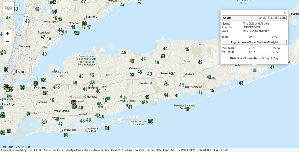
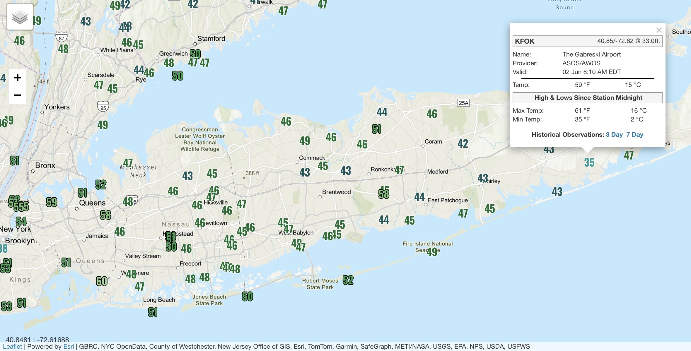
Wunderground? I didn’t look there yet. Only other ob I saw was 42° I’m not saying it’s wrong. But a lot of these ASOS sitings don’t seem to represent the area.
-
True MEX MOS is 80 to 88 every day thru Saturday ( that includes Saturday ). That's a 4 days of 80s? Decent. I was just musing with Scott that in principle we haven't committed to the warm season yet. We've had heat, but until the basal return pattern state stops dipping lows below 40 this is a zombie winter. Imho of course... There's either a standard c-front (Euro) or a BD (CMC/GFS) late Saturday night and Sunday's on the cool side, but at this time ...the modeled air mass/thicknesses are not that 47 F shit. More like bopping us back to 64. Could be wet, or it could be dry...then ,there's another warm push mid next week - that one looks more like a warm sector Don't have much of a bead on post 15th June yet
-

2026-2027 Strong/Super El Nino
michsnowfreak replied to Stormchaserchuck1's topic in Weather Forecasting and Discussion
Unpopular opinion here. 1997-98 wasnt AS bad as it gets a rep for in the Great Lakes. It sucked, but an nunprecedented shutout (just a T) in February sealed its fate in infamy. Nov-Jan was ok, multiple rounds of snow (then a few more in March). The 2nd half of January was solid white ground and gray skies and the temp barely moved. Good enough for snow but I imagine terrible for ice fishing. Still high on the list of winters I dont care to ever see again, but significantly better than 1982-83. -
No prolonged cool anytime soon
-
Still winter if you took a polar rotted January thermal profile and subjected it to June sun, you'd get that January sfc temp to be just like yesterday
-
FWIW I did see a 33 and 34 nearby on PWS.
-
ASOS can be so weird in rad pits lol. FOK, OWD, MVY, SLK, SFM… Often 10F colder than anything around them on rad nights.
-
I don't think we've had "prolonged" heat here for years. We've had heat waves, ...usually falling short of what they could have been when they do with just one day out of them that gets to 97.. Kind of like what happened earlier in May ... some with more or less DP to go along with. But they're too many reasons to neg interfere. I'm beginning to think the return rate around here is so long there's no practical value in really looking much less waiting for them. Those 97 for five days running over lows of 76 with 82 in the urban centers are Chicago to KC or NYC S.
-
Crazy I still have to wear my motorcycle liner jacket and it's June already. 19 days til sunlight starts decreasing.
-
I think today's gonna seem pretty warm W of I-95 Wouldn't be shocked if Scott to Ray sniff Labrador's nut sack in the afternoon. Such a weak gradient in place and the intensity of the 100% bake in the interior, seems they delay warm arrival by one last reach back face smack upon exit of this pattern. LOL. Or not... where not, MAV/MET MOS have both inched closer to 80 for today. Right now they're 78 .. 79 around the BDL-FIT-ASH horn. Testing that
-
so a hugely rangy summer then -
-
2026-2027 Strong/Super El Nino
40/70 Benchmark replied to Stormchaserchuck1's topic in Weather Forecasting and Discussion
I think it's important to not get too cute with the EMI when ENSO gets this strong because all of them are going to be "basin wide" in the sense that the anomalies will encompass the entirety of the ENSO area. Good luck getting 2.5C in the east or west, and having 0C on the other end. This is why I'm not really focused too much on EMI. -
I had raindrops on my windshield this morning. This guy is full of it.
- Today
-
2026-2027 Strong/Super El Nino
40/70 Benchmark replied to Stormchaserchuck1's topic in Weather Forecasting and Discussion
Another nod towards 1997. -
2026-2027 Strong/Super El Nino
40/70 Benchmark replied to Stormchaserchuck1's topic in Weather Forecasting and Discussion
Usually the seasonal guidance will be biased towards stock ENSO, so when a seasonal model shows that output leading into an intense El Nino episode, it should provide reason for pause. -
NYC hasn’t had a month with above normal precipitation since May 2025. So the last 12 months actually made the top 20 driest for June to May. This is impressive given the overall wetter pattern since 2003. Time Series Summary for NY CITY CENTRAL PARK, NY Driest 6-1 through 5-31 Click column heading to sort ascending, click again to sort descending. 1 1966-05-31 27.85 0 2 1950-05-31 30.86 0 3 1965-05-31 30.93 0 4 1930-05-31 31.46 0 5 1954-05-31 32.13 0 6 1911-05-31 32.59 0 7 1959-05-31 32.63 0 8 2002-05-31 32.73 0 9 1882-05-31 33.45 0 10 1962-05-31 34.16 0 11 1877-05-31 34.24 0 12 1957-05-31 34.82 0 13 1963-05-31 35.08 0 - 1887-05-31 35.08 0 14 1955-05-31 35.17 0 15 1925-05-31 35.28 0 16 2026-05-31 35.44 0 17 1981-05-31 35.58 0 18 1907-05-31 36.03 0 19 1932-05-31 36.06 0 20 1892-05-31 36.23 0


.thumb.gif.f92b16c631a1d15d405ed77b33f0710d.gif)


