All Activity
- Past hour
-
Squalls already developing coming out of the mountains up here.
-

December 2025 regional war/obs/disco thread
WinterWolf replied to Torch Tiger's topic in New England
All of us know this…how come NWS and TV METS can’t seem to grasp it? And in December of all months lol. -

December 2025 regional war/obs/disco thread
Typhoon Tip replied to Torch Tiger's topic in New England
I wish. Lol Xmas party with a different sphere -
Good luck all. Hope you get some nice snow tomorrow
-

December 2025 regional war/obs/disco thread
weatherwiz replied to Torch Tiger's topic in New England
The sun angle and warm ground stuff is the biggest nonsense out there. It is only a factor when you're talking abut light rates and when intensity is too light to readily accumulate. When they go from 85 to 26 (in the same day!!) in Denver does the warm ground stop them from getting a foot? No, it does not -
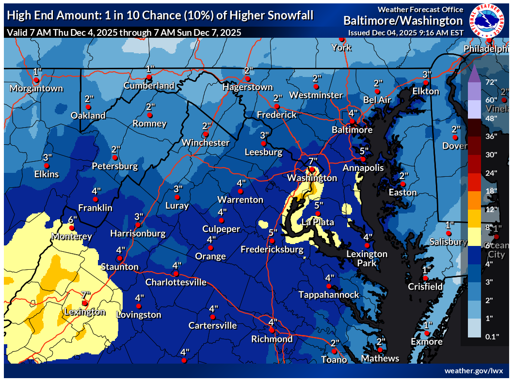
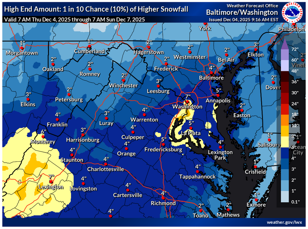
Seems like a general consensus being drummed up via CAMs this morning. Feel like flurries will reach north of I-70 with measurable (0.1”+) probably around I-70 with a small incremental increase the further south you go. Rt50 is likely the dividing line for where 1” is possible in this scenario across VA/MD. Slightly better chance north of Rt50 as you get into Sussex County DE. Best chance will be I-66 on south with 2-4” local to 6” across Southwest VA true Central VA, albeit lower side of things as you come off the terrain. System struggling to gain latitude and the drier antecedent airmass will be the main issue for majority of the sub. Bob Chill and Wxdude-ville will have the best opportunity here. CVille folks will have a nice little snowfall to start the season as well.
-
December 2025 regional war/obs/disco thread
WinterWolf replied to Torch Tiger's topic in New England
I like the active look though going forward as dryslot mentioned…I think there will be quite a few chances coming up, just gotta sit tight for a bit longer. -
Just imagine if this verified... but more seriously how is this outcome possible? Would a surprise coastal pop off?
-
BRRR! -10's with a couple -20's this morning. -sd's along the shoreline. -5 here in town (ranked 4th coldest). Dark over the lake with heavy sea smoke. Radar picking up an LES band over the water. BTW, the Sun just made it over the sea smoke. Takes a couple hrs after sunrise. -12 Duluth (3rd) -18 Hibbing (1st beat -17 1991) -11 Brainerd (1st beat -2 1991) -9 Ashland (T 1st -9 1972)
-
I honestly wonder if the last few winters are playing into it. We’ve had so much marginal temps and warmth since 2022. Last year was colder but we still had marginal temps in several storms. I think it will take a few bigger events to clear out the stench/hangover. Also to be fair, the sfc temps looked pretty warm last event…but they busted much colder. I would prefer they just say the temps are marginal as the reason and not talk about December sun angles.
-
December 2025 regional war/obs/disco thread
WinterWolf replied to Torch Tiger's topic in New England
We had a positive trend for some on Tuesday, when the colder air held tough and over performed in a lot of inland area. It was a small win in that regard. So maybe we can keep the trend going…? -
4amish
-
Bet the dry air will push it later than we think. I am thinking 7-8 at my area in W PWC.
-

December 2025 regional war/obs/disco thread
Sey-Mour Snow replied to Torch Tiger's topic in New England
And Miami will have the same as Weymouth and Seymour -
Man this forum is pretty dead considering we have a chance at a little wintry mix early in the season...I know the Triangle isn't looking at much potential, hoping I can squeeze a little something out of this system here in Hillsborough. I'm a little less than an hour south of Danville.
-
What time is the onset of precipitation? Nam is super early. .
-
December 2025 regional war/obs/disco thread
WinterWolf replied to Torch Tiger's topic in New England
Exactly. But we have pro METS talking about sun angle and warm ground. Laughable. -

December 2025 regional war/obs/disco thread
Ginx snewx replied to Torch Tiger's topic in New England
Again CNE to Ray and Central Mass,good chance of a brief heavy heavy squall along the Arctic Boundary. This is in 40/70s hood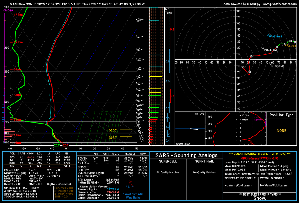
-
December 2025 regional war/obs/disco thread
WinterWolf replied to Torch Tiger's topic in New England
Honestly, where do some of these METS(NWS/TV etc) get their flawed ideas/knowledge from, that they are misleading the general public with. It’s pathetic actually. -
Can't we just put to bed the sun angle garbage? It is such a misnomer.
-
These overnight runs really do us dirty, but we always come back during the day.
-

Richmond Metro/Hampton Roads Area Discussion
TampaMan replied to RIC Airport's topic in Mid Atlantic
I moved from Richmond to Tampa last Friday. I am extremely upset right now… -
Definitely feeling more confident in seeing "something" vs. a complete miss. Toggling through some of the other models (crappy ones mostly while bored), everything seems to pushing coverage north.
-
And we had forecasts worried about sun angle in December a couple days ago. I also still have ice on the trees.
-

December 2025 Short/Medium Range Forecast Thread
housemtnTN replied to John1122's topic in Tennessee Valley
So snow in the tn valley is basically a crapshoot at the moment? I've been trying to educate myself on what makes this particular area so difficult to forecast, it's really fascinating to me.