All Activity
- Past hour
-
Euro looking a lot like Rap and Hrrr, but with its typical drier solution.
-
Kuchie
.thumb.png.62e2edb6bd98ae78e6283c814c8edd81.png)
-

December 2025 regional war/obs/disco thread
mahk_webstah replied to Torch Tiger's topic in New England
Seems like the cooldown after a few warm days is still on target for just before Christmas? And with snow chances -

Minor snowfall sunday 12/14/25 1-4” possible
MJO812 replied to WeatherGeek2025's topic in New York City Metro
6z aifs bumped north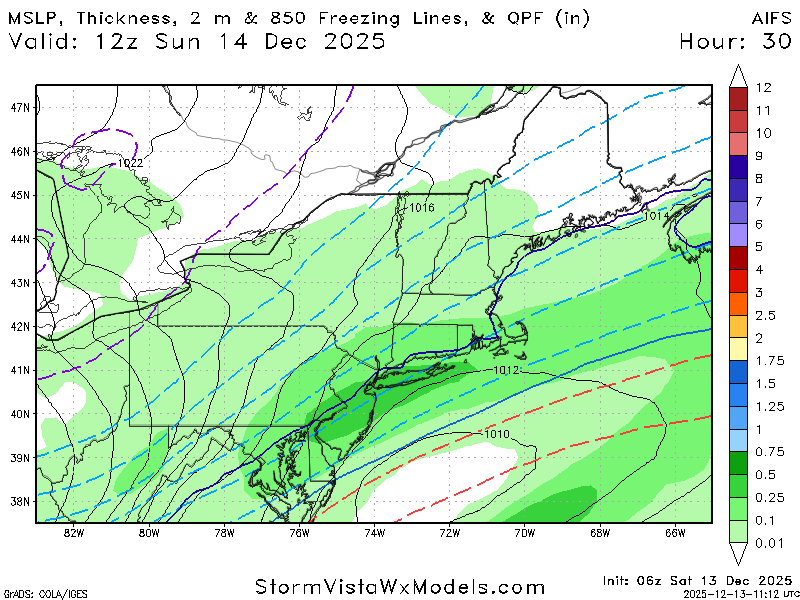
-
December 2025 regional war/obs/disco thread
mahk_webstah replied to Torch Tiger's topic in New England
I’m talking about the low that’s over Newfoundland. Move it 250 miles northeast allows a storm to climb the coast doesn’t it? And even stall with all that blocking. -
Way too much cold air to the north to be a blowtorch pattern
-
Mount Holly is pretty bullish For this package, main changes to the forecast were a modest uptick in snowfall, which resulted in an expansion of the winter weather advisory northward and southward. Both expansions are still a little marginal, 2-4 inches along the I-78/I-287 corridors (criteria is 3 here) and 1-3 inches in Sussex County Delaware (criteria is 2 here), but enough confidence is present to bring them into the fold. Across a large central portion of the advisory, areas along and southeast of I-95 in PA, NJ DE and MD, we`re now expecting a wide area of 3-5 inches, and there are some snowier models suggesting a stripe of warning criteria (which is mostly 5 inches in this area, though 6 in central NJ) could occur. Not quite sold on that yet given potential for lost QPF from the transition from rain to snow, but its definitely on our minds for potential changes. For now however, kept advisory level forecast across this region, though high-end for sure.
-
-
Minor snowfall sunday 12/14/25 1-4” possible
MJO812 replied to WeatherGeek2025's topic in New York City Metro
Euro also -

Minor snowfall sunday 12/14/25 1-4” possible
EasternLI replied to WeatherGeek2025's topic in New York City Metro
Soundings aren't looking half bad... When the lift comes through it's smack in the DGZ. Should see a pretty good shot of snow growth with this. Not really seeing any dry layers to eat it up. That's on the nam. If the RRFS were to verify, would put my area right near average snow for the entire month of December. Something that hasn't happened here since winter 20-21.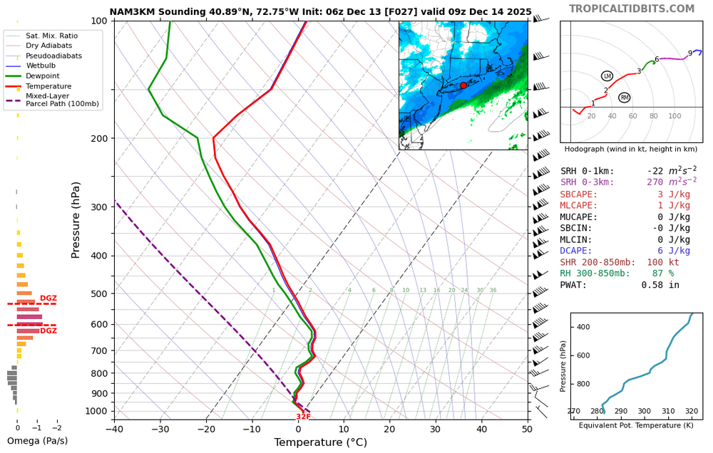
-
Euro 6z with its best run yet!
-

December 14th - Snow showers or Plowable snow?
moneypitmike replied to Sey-Mour Snow's topic in New England
The rare GON to HYN win. -
Are we aiming for suppression?
-

12/14: Sunday funday? Will the south win again?
Ralph Wiggum replied to TSSN+'s topic in Mid Atlantic
Anyone have the latest Rufus (future Nam replacement)? -

Minor snowfall sunday 12/14/25 1-4” possible
Yanksfan replied to WeatherGeek2025's topic in New York City Metro
Good to see the 6z models improved over the 00z runs. 3-5” is a good call right now. One more bump north and we will be in warning criteria snowfall. -

Central PA Winter 25/26 Discussion and Obs
mahantango#1 replied to MAG5035's topic in Upstate New York/Pennsylvania
Me too, 19 here now, but last night it got down to 13 here -
December 2025 regional war/obs/disco thread
mahk_webstah replied to Torch Tiger's topic in New England
The place is magical. I keep telling the weenies to go up for a few days. -
December 2025 regional war/obs/disco thread
mahk_webstah replied to Torch Tiger's topic in New England
Shove that se Canada low 250 miles ne -
Some sort of CAD wedge will develop and we’ll be stuck at 45 degrees and drizzle all day. Book it.
-

December 14th - Snow showers or Plowable snow?
BrianW replied to Sey-Mour Snow's topic in New England
Yeah. So serene. Looks like a nice deep winter feel here on the shoreline for a few days. SHORT TERM /6 PM THIS EVENING THROUGH MONDAY NIGHT/... Key Points: * 1 to 4 inches of snow are expected across the area tonight into Sunday morning, with up to 5 inches in eastern Long Island. * Winter Weather Advisories have been expanded slightly west and north to include all coastal zones from 10pm tonight through 1pm Sunday. * Windy and cold Sunday night into Monday morning with wind chills below zero in some areas.
-
-
Although it still favors north as last night's 3z run, the 9z run of the Rap would be acceptable to most I think.
.thumb.png.6aa9919e8b669233ae25130e3b2a4e49.png)
-
Today’s temp max seem to be playing a bigger part than most modeling indicated before last night.
-
6z Ukie maintains the northern idea fwiw
.thumb.png.e48553ac7ccd1155b845b01f6bf9935f.png)
-
The nams seem worthless to change that much so close to game time

.png.001254a48e7779813e35229a4b0972bc.png)


.png.d369fa9bd7cba10bde2c8c89073068ab.png)
.png.7612cdddf2ab6c478b81c999e37f6db7.png)