All Activity
- Past hour
-

The “I bring the mojo” Jan 30-Feb 1 potential winter storm
ncforecaster89 replied to lilj4425's topic in Southeastern States
It’s a direct consequence of the more eastward track and finding ourselves in the strong subsidence zone, while the more inland areas are in the deformation zone. There’s always going to be winners and losers in these type of setups…with a coastal low that’s bombing. In this particular run/solution, we are the undisputed losers. But like Josh noted, it’s still too early to pinpoint the precise location of these dynamics.
-

Richmond Metro/Hampton Roads Area Discussion
overcautionisbad replied to RIC Airport's topic in Mid Atlantic
Possible. It's going to whatever it does models or not. In fact models are so all over the place I'm not sure anyone will be certain until its happening -

The “I bring the mojo” Jan 30-Feb 1 potential winter storm
lilj4425 replied to lilj4425's topic in Southeastern States
Models all over the damn place still. I’m everywhere from a dusting (NAM) to almost ten inches (Euro) depending on which one you look at. lol. -

The “I bring the mojo” Jan 30-Feb 1 potential winter storm
senc30 replied to lilj4425's topic in Southeastern States
Looks like the gfs dropped numbers a lot for the coastal area. -

The “I bring the mojo” Jan 30-Feb 1 potential winter storm
JoshM replied to lilj4425's topic in Southeastern States
Definitely, someone’s going to get screwed by the dry air. But that’s a now cast thing. -
The “I bring the mojo” Jan 30-Feb 1 potential winter storm
JoshM replied to lilj4425's topic in Southeastern States

-
The “I bring the mojo” Jan 30-Feb 1 potential winter storm
JoshM replied to lilj4425's topic in Southeastern States
Looking similar to 0z -
The “I bring the mojo” Jan 30-Feb 1 potential winter storm
JoshM replied to lilj4425's topic in Southeastern States
6z running … steady as she goes thru hour 30 -
-
The “I bring the mojo” Jan 30-Feb 1 potential winter storm
ncforecaster89 replied to lilj4425's topic in Southeastern States
You’re correct in that the NAM is more prone to exaggerated dry slots than the globals (such as the ECMWF and GFS). Even so, the physics still apply and is a definite cause for concern. It was also seen on the 18Z ECMWF, as well. In both cases, the dry slot was directly over my house! -
The “I bring the mojo” Jan 30-Feb 1 potential winter storm
JoshM replied to lilj4425's topic in Southeastern States
Well, the NAM has a bias to overamp these things , so I’m hoping it’s out to lunch for now -

Richmond Metro/Hampton Roads Area Discussion
eaglesin2011 replied to RIC Airport's topic in Mid Atlantic
That Nam run is just about the best run you can have for the RVA & VA Beach area… Everything just backfills perfectly & it’s not north enough to get more dry air pulled into it. Now if it could just actually happen like that .. lol -
NAM and to some extent the Icon there continue to have me spooked, but man have we longed for times like these....
-

1-30/2-1-26 Arctic Blast, ULL Snow Event
Uncle Nasty replied to John1122's topic in Tennessee Valley
I fell asleep before our local 11:00 news last night. The 6 o'clock news had our highs for Friday (now today) at 46°. When (if) the moisture arrives, starting as light rain and then changing to snow when the cold air filters in. Channel 3 has us up to 2". Channel 9 a dusting to 1". Curious what they will be showing in a few minutes with the morning crew. 2" is not much, if we can manage to get that, BUT, with temps in the low to mid 20's for Saturday highs, everything should at least be covered white and stick around a few days. I'd rather have 2" on the ground a few days instead of those 4" snows that melt off within 4 or 5 hours. I'm still skeptical about losing what we might get to virga. Edit to add: our forecast low was 26°. We bottomed out in Ooltewah at 19° and currently sitting at 20°. Sent from my SM-S916U using Tapatalk -
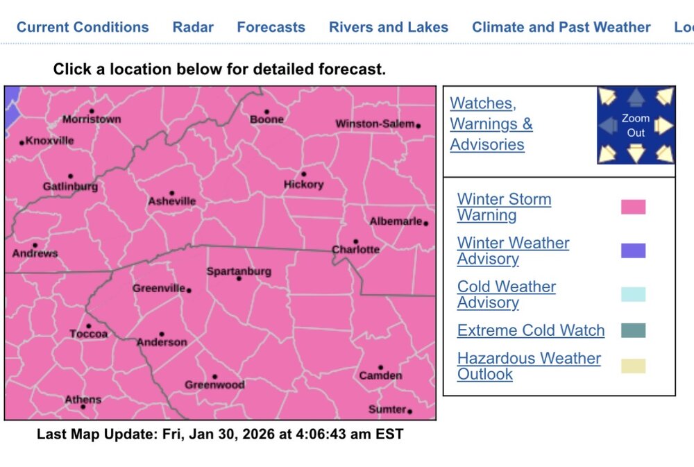
Richmond Metro/Hampton Roads Area Discussion
overcautionisbad replied to RIC Airport's topic in Mid Atlantic
The NAM has spoken and we must listen -

The Jan 31 Potential: Stormtracker Failure or 'Tracker Trouncing
hstorm replied to stormtracker's topic in Mid Atlantic
RGEM is slightly north too, at least with the overall precip field. 12k NAM has 1”+ snow up to around Fredericksburg. -
The “I bring the mojo” Jan 30-Feb 1 potential winter storm
ncforecaster89 replied to lilj4425's topic in Southeastern States
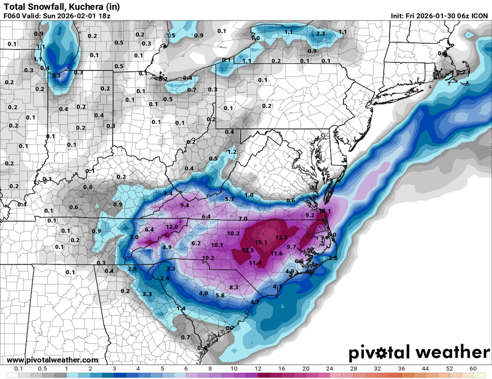
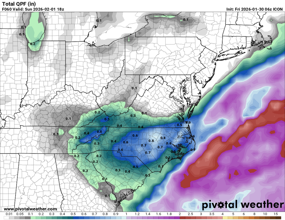
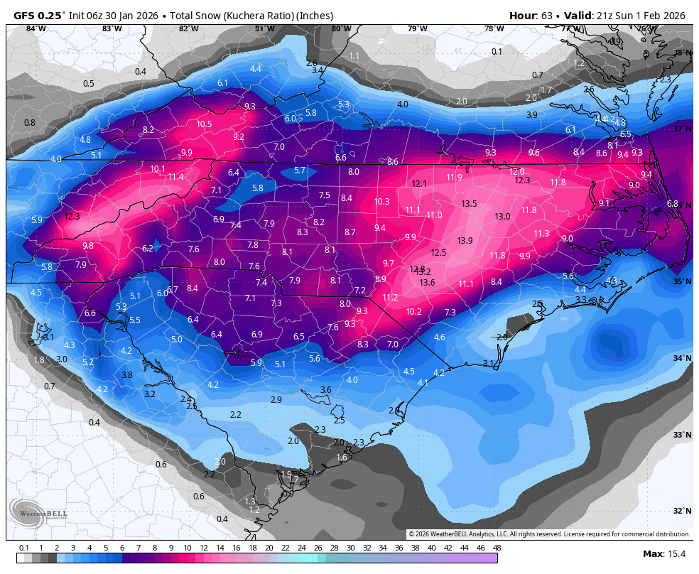
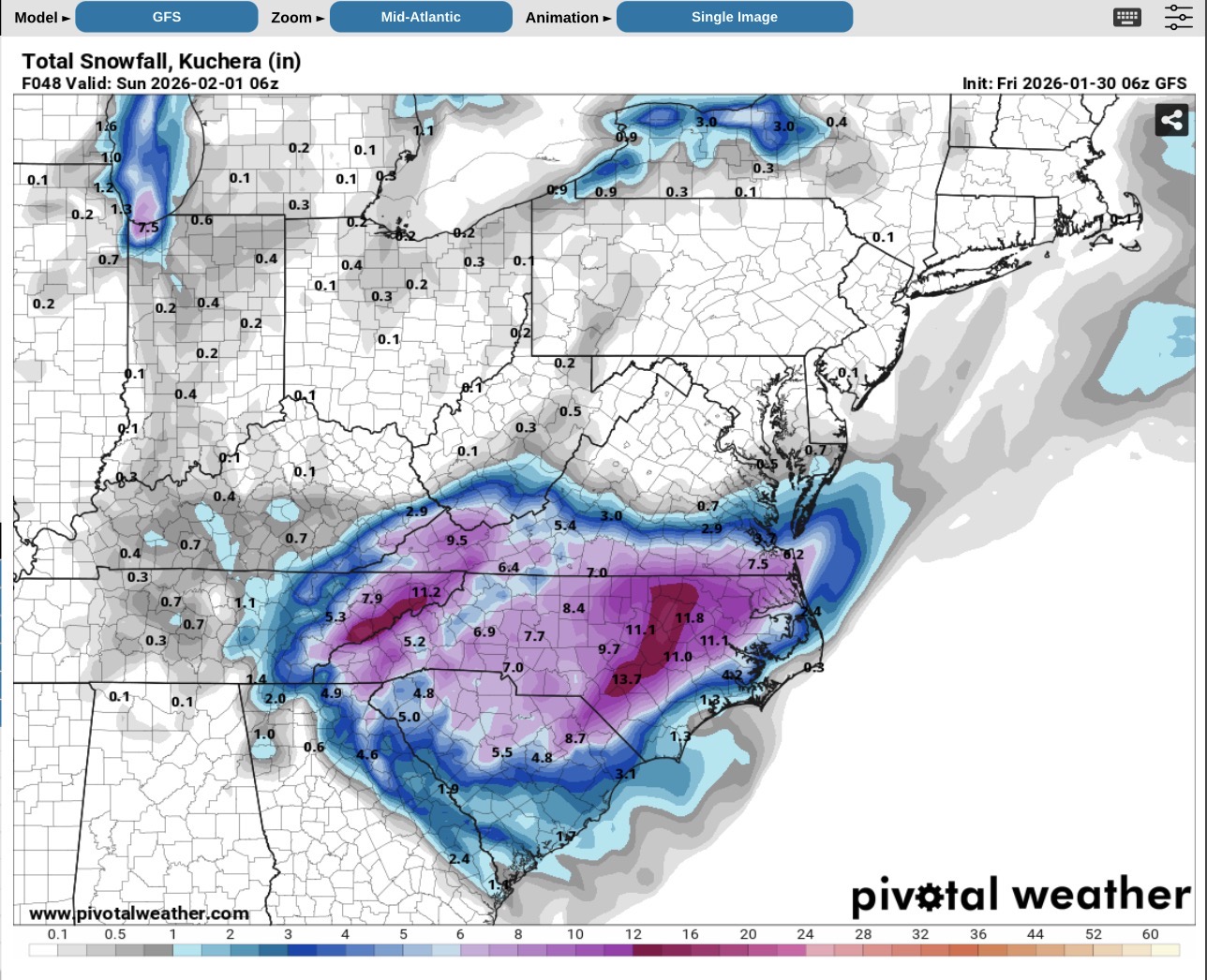
In simplest terms, it’s the result of the coastal low tracking farther offshore as it’s undergoing bombogenesis…where the deformation zone is positioned more to the north/northeast, favoring central/eastern NC and SE VA with high totals (10-20+ inches along the coast and inland). However, this setup allows dry mid/upper-level air to wrap cyclonically around the low's southwestern/southern flank from the southwest, creating a pronounced dry slot that intrudes into SE NC. The worst part of this particular scenario is that the dry air wraps in during the peak precip phase, leading to an abrupt transition from heavy bands (e.g., near New Bern/Kitty Hawk) to much lower/no accumulations in Wilmington and other SE coastal zones. That said, this is a common feature in these explosive coastal setups, especially when the low stays a bit farther east, as shown in that 06Z 12km NAM run. -
Latest Canadian gets RVA into the game some. Though, like you mentioned, areas on the edge will battle that dry air.
-
- 571 replies
-
- 1
-

-
- extreme cold
- snow
- (and 1 more)
-

The “I bring the mojo” Jan 30-Feb 1 potential winter storm
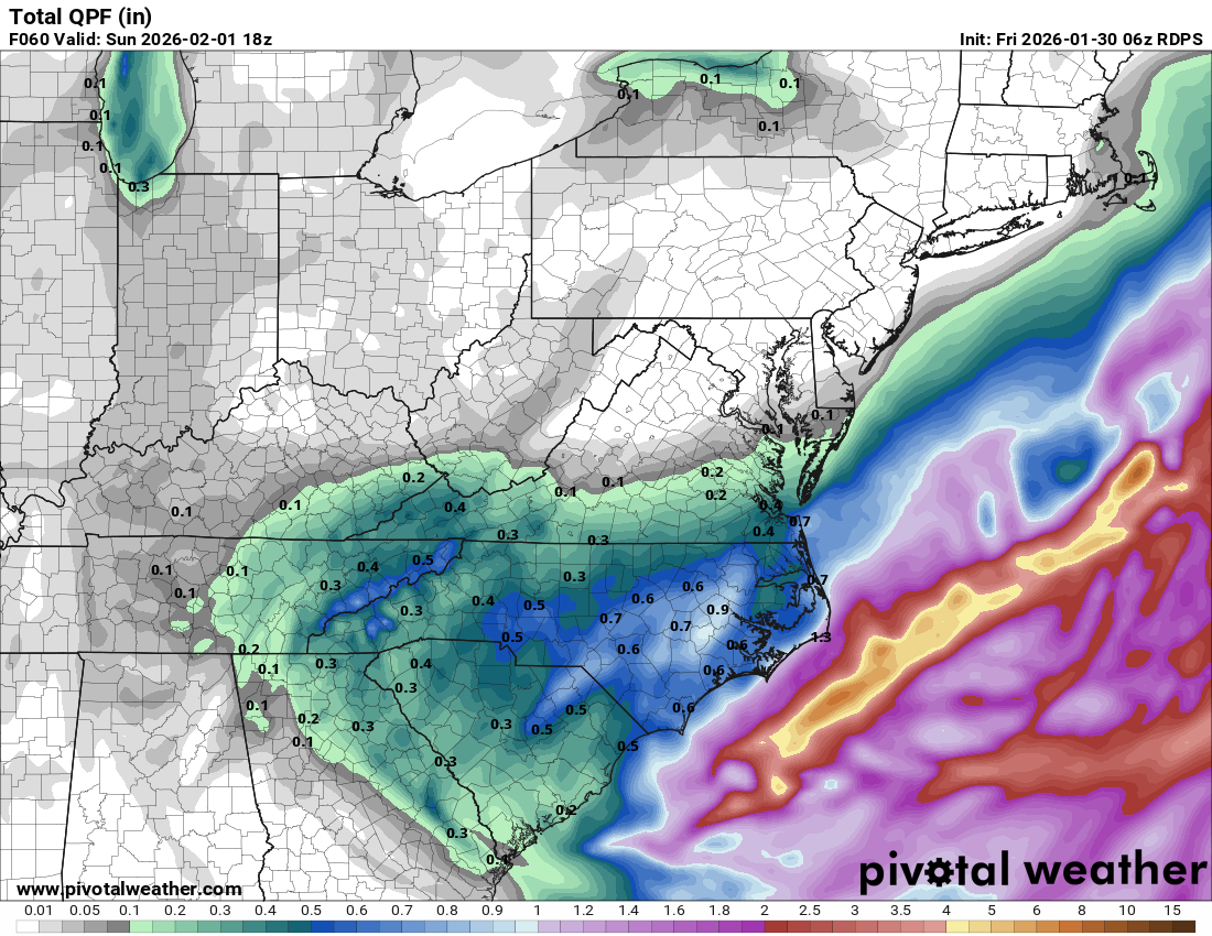
timnc910 replied to lilj4425's topic in Southeastern States
6z RDPS

-
Richmond Metro/Hampton Roads Area Discussion
eaglesin2011 replied to RIC Airport's topic in Mid Atlantic
For those of you in the VA Beach area.. That’s just missing the RVA area but just a slight bump north would make all the difference in this run.. The build up just south of us is a good sign… I can’t tell if this moved more north from the prior runs but it definitely is putting out more precip in areas near the boarder & Va Beach -

The “I bring the mojo” Jan 30-Feb 1 potential winter storm
wxdawg10 replied to lilj4425's topic in Southeastern States
Dream set up for the triangle east. Honestly it seems like the consensus is reverting back to that area between Raleigh and Greenville being the jackpot, similar to what was being modeled earlier in the week with the low being closer to the coast. Regardless i think most of the state gets atleast 3 inches. Georgia and SC folks i'd be a little nervous though -

Possible coastal storm centered on Feb 1 2026.
MaineJayhawk replied to Typhoon Tip's topic in New England
*you’re -

The “I bring the mojo” Jan 30-Feb 1 potential winter storm
Snowncanes replied to lilj4425's topic in Southeastern States
ULL is a bit more north and transfers earlier. I still think y’all will be fine in the upstate in the 3-6 range -
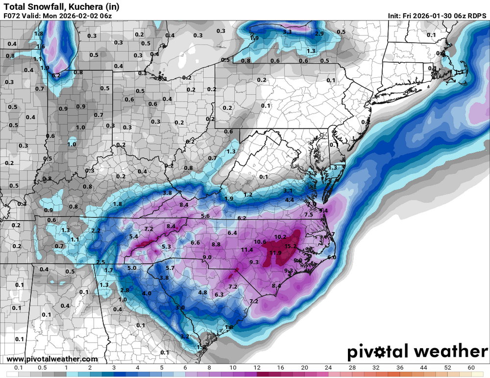
The “I bring the mojo” Jan 30-Feb 1 potential winter storm
timnc910 replied to lilj4425's topic in Southeastern States
6z ICON