All Activity
- Past hour
-
Canadian Kuchie
.thumb.png.93e941af5052e4ccc429eb73d2bec335.png)
-

2025-2026 ENSO
vegan_edible replied to 40/70 Benchmark's topic in Weather Forecasting and Discussion
NOW this is the excitement i like to see around winter weather! -
Are you sure you aren't thinking about the 1" "during commute" for advisories. I do not recall something like you are mentioning in my 34 years living here.
-

12/14: Sunday funday? Will the south win again?
Weather Will replied to TSSN+'s topic in Mid Atlantic
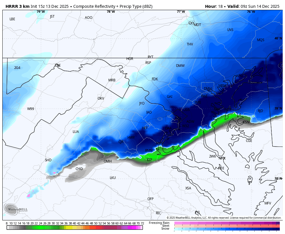
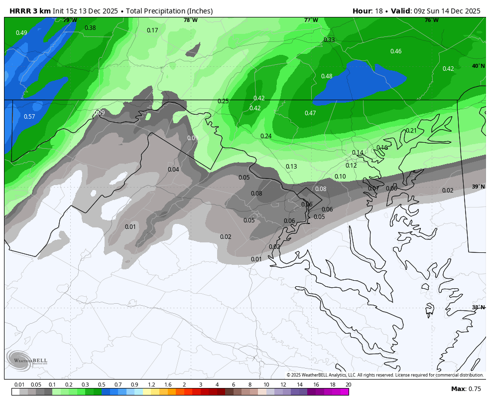
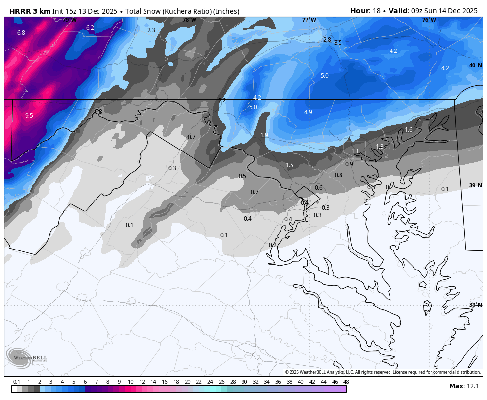
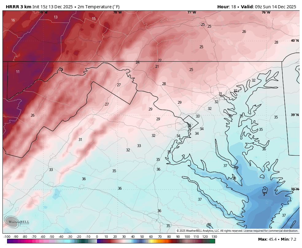
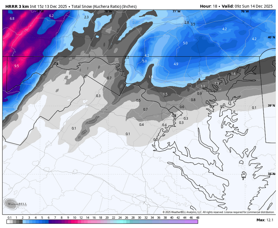
WB 15Z HRRR at HR 18.

-

12/14: Sunday funday? Will the south win again?
winter_warlock replied to TSSN+'s topic in Mid Atlantic
They also take into account location. If u live in Alabama, a 1 to 3 inch storm is warning level. We're as that's just an advisory here,.. but I could be totally wrong... As my wife likes to tell me lol -
I think better than 10:1 under heavy echos.
-
Go fuck yourself, I’ve had enough of subhuman vermin who simply exist to make others miserable. I don’t care about being classy with you anymore because I don’t respect you as a human being. I tried to be respectful and acknowledged some of your good qualities because I believed you have potential, but you refuse to correct your issues. I no longer think you can be redeemed. Genuinely, the world would be a better place if you offed yourself. You are rude to people who are respectful. Yes, I am an asshole but I’m putting my darkness to good use. You are a bad person, and nobody will miss you if you die besides a few other like minded people.
-
12/14: Sunday funday? Will the south win again?
winter_warlock replied to TSSN+'s topic in Mid Atlantic
They gotta do that and use the stuff to get there budget for next year -

12/14: Sunday funday? Will the south win again?
MDScienceTeacher replied to TSSN+'s topic in Mid Atlantic
Actually, no, I’ve seen a warning for a 2 to 4 inch so I think they take into consideration overall conditions, especially if there is a chance for dynamic snow that’s gonna take people by surprise -

December 11th-14th Double Banger Clippers
Radtechwxman replied to Jackstraw's topic in Lakes/Ohio Valley
Im sorry man. I know how that feels. All too well. Pretty much all last winter got missed. Peoria has already surpassed all of last winter's snow. Looks like after a torch for a bit maybe some interesting stuff around Xmas. I was surprised myself these followed basically the same track or close to. -
 FBXwinterfan changed their profile photo
 -
For what it is worth- I just ruined all snow for the rest of the season…. Bought a snowblower [emoji21] .
-
12/14: Sunday funday? Will the south win again?
FBXwinterfan replied to TSSN+'s topic in Mid Atlantic
I was surprised to see Spotsylvania roads pre-treated for maybe flurries. -
12/14: Sunday funday? Will the south win again?
winter_warlock replied to TSSN+'s topic in Mid Atlantic
Color code says 2 to 3. Noaa is goofy lol -
I'd think if the more bullish model trends continue (let's see how the Euro's 12Z run looks), NWS could issue some warnings with their afternoon package if there's a decent chance the necessary criteria for a warning could be met.
-
I mean a warning is 5” or more, not road conditions haha.
-
12/14: Sunday funday? Will the south win again?
winter_warlock replied to TSSN+'s topic in Mid Atlantic
I agree. Latest modeling shows warning criteria for a lot of us . Maybe LWX is waiting till the afternoon update -
 Have fun to all going today. Wish I didn't have something going on in Stamford later (that I paid for, otherwise I would have dropped). Hoping we can do a late winter or spring one
 -
(002).thumb.png.6e3d9d46bca5fe41aab7a74871dd8af8.png)
Saturday night/Sunday 12/13-12/14 Jawn
ChescoWx replied to Ralph Wiggum's topic in Philadelphia Region
Below is the experimental RRFS that I believe will replace the NAM maybe as early as next month. -
 37 on a southerly wind here
 -

12/14: Sunday funday? Will the south win again?
BTRWx's Thanks Giving replied to TSSN+'s topic in Mid Atlantic
How is that 1" for D.C.? lmao Same with Baltimore. The numerical values don't match the gradients. -
12/14: Sunday funday? Will the south win again?
MDScienceTeacher replied to TSSN+'s topic in Mid Atlantic
I don’t understand why this is not a warning for Carrol, Baltimore, Harford counties. With the cold air mass in place and the possibility for moderate to heavy snow over a short period of time roads will be extremely bad. -

Moderate snowfall 12/14/2025 WWA up for most of the area
psv88 replied to WeatherGeek2025's topic in New York City Metro
39 now. -
December 14th - Snow showers or Plowable snow?
weatherwiz replied to Sey-Mour Snow's topic in New England
Well after looking over this morning made some tweaks and here are some thoughts/reasonings to go along I originally wanted to do the ranges as 2-4" and C-2" yesterday but there are certain ranges I hate doing (2-5" and C-2" are a few of them). Not that I make these forecasts or maps for anyone (outside of just posting for friends and here) but those ranges drive me nuts. I guess they're fine when doing a larger area but they still drive me nuts. I am still very cautious about how far north the fronto banding gets and for anything more than an inch of snow, it's going to be banding or bust. Under the banding, is where snow growth and ratios will be maximized with ratios upwards of 15:1 and maybe even 18:1 if the banding verifies even stronger. Caveat with this is, the stronger the banding, the greater the likelihood there will be some degree of subsidence north of the banding. Outside of the banding, snow growth and subsequent flake size will struggle. Under the banding you'll see the flat and fluffy dendrites, outside of the banding we'll see much smaller flakes size and the rates are going to be relatively meh and accumulation won't be sufficient (hence the Up to a coating). Radar is just going to be kind of putrid looking, except where the banding is. The other issue is going to be the speed - this won't be as much of a factor where the fronto evolves (but will make it difficult to get widespread totals > 5", but we're only looking at maybe 4-6 hours of snow with rates not even close to 1/2" per hour.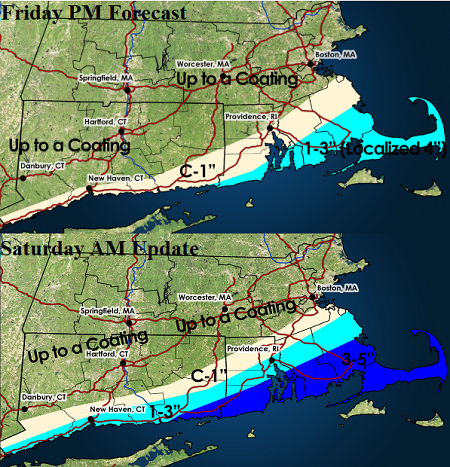
-
12/14: Sunday funday? Will the south win again?
winter_warlock replied to TSSN+'s topic in Mid Atlantic
Looking like a decent 3-6 inch snowstorm for a lot of us in central md se pa, northern Delaware. Alot of us are probably going to exceed December climo snow before mid month! -

December 2025 regional war/obs/disco thread
40/70 Benchmark replied to Torch Tiger's topic in New England
Fine with me, as I'm missing tomorrow, anyway.

.png.6812274f479ee053ed5dc65259151c7f.png)