All Activity
- Past hour
-
That looks to be about the extent of it.
-
Hopefully, we can see some improvement in the dry pattern this year which began in the fall of 2024.
-

January 2026 regional war/obs/disco thread
Sey-Mour Snow replied to Baroclinic Zone's topic in New England
Looks inevitable for at least one day .. next Saturday, I’d it trends colder could stay in 40s but if we trend a bit warmer we hit the 60s.. -
January 2026 regional war/obs/disco thread
Sey-Mour Snow replied to Baroclinic Zone's topic in New England
I agree with you, definitely have hope up there and the thaw is quick 3-5 days. -
Eighty inches of snow! That's nearly seven FEET! Sounds like a snow job to me, lol...
-

January 2026 regional war/obs/disco thread
ineedsnow replied to Baroclinic Zone's topic in New England
6z GFS has snow to ice.. ICON.and Ukie are advisory snows.. Euro a mix -

January 2026 regional war/obs/disco thread
Damage In Tolland replied to Baroclinic Zone's topic in New England
I don’t see 50’s anywhere. -
Heavy snow right now in Mammoth, just piling up - It's not giving the plow guy a break in the Woolly Lot right now - He'll be at it all day. https://www.mammothmountain.com/on-the-mountain/mammoth-webcam/woolly-cam That pacific conveyor belt smashing up against the cordillera - It's not gonna give no quarter, none at all throughout today.
-

Central PA Winter 25/26 Discussion and Obs
pawatch replied to MAG5035's topic in Upstate New York/Pennsylvania
22 degrees this morning. SOS cold. Looks like a chance of flurries again today. -

January 2026 regional war/obs/disco thread
CoastalWx replied to Baroclinic Zone's topic in New England
I mean you can loop them, but looks like garbage until mid month especially down here. And even after that doesn’t exactly move the needle for me. -
January 2026 regional war/obs/disco thread
CoastalWx replied to Baroclinic Zone's topic in New England
Not what they show. Maybe to start? -

January 2026 regional war/obs/disco thread
mahk_webstah replied to Baroclinic Zone's topic in New England
You know more than me Scott. I figure 2-4” tues pm Wednesday maybe ends as drizzle. Then it warms up a bit but maybe it not too much. Then the week of the 11th gets interesting. That’s my takeaway. The hint towards a colder trend in 0z guidance? I don’t look at models I just read others’ interpretations. -
January 2026 regional war/obs/disco thread
ineedsnow replied to Baroclinic Zone's topic in New England
Not here.. i think it will be snow or a mix -
January 2026 regional war/obs/disco thread
Sey-Mour Snow replied to Baroclinic Zone's topic in New England
Ya , clean the rods off Wednesday through Sunday with 40s and 50s. Then we reshuffle. -
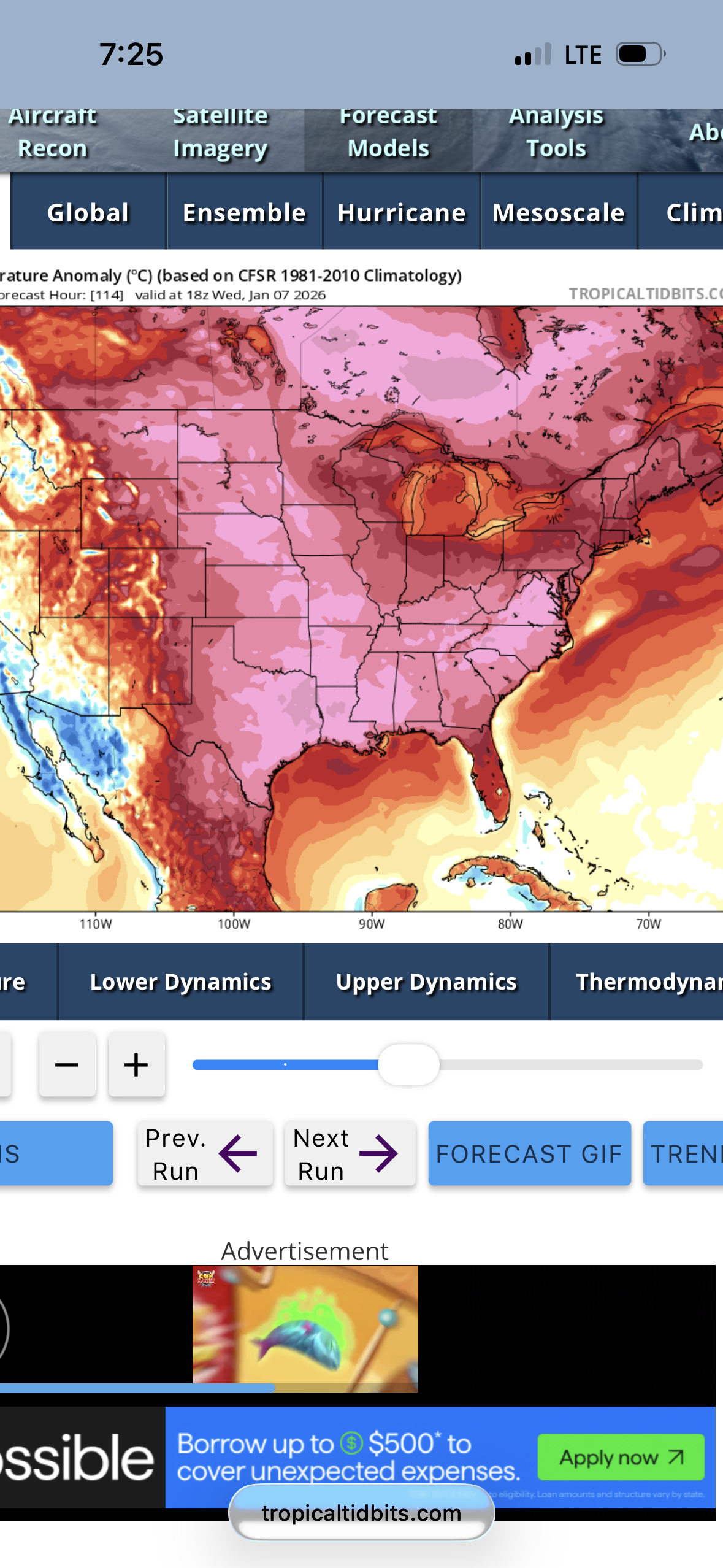
Looks like Ray @40/70 Benchmark was right about the SPV strengthening in January……
-
January 2026 regional war/obs/disco thread
CoastalWx replied to Baroclinic Zone's topic in New England
Pattern looks like garbage until mid month. -
January 2026 regional war/obs/disco thread
CoastalWx replied to Baroclinic Zone's topic in New England
Yeah he’s NW or concord. But not sure what GYX means by cooler trends. -
January 2026 regional war/obs/disco thread
Sey-Mour Snow replied to Baroclinic Zone's topic in New England
GFS and Canadian are close for him Tuesday PM. rain pike south .. maybe 1-3” Monday too for Mass and points north -
January 2026 regional war/obs/disco thread
CoastalWx replied to Baroclinic Zone's topic in New England
Looks cool to me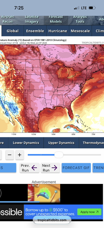
-
January 2026 regional war/obs/disco thread
CoastalWx replied to Baroclinic Zone's topic in New England
Looks mild with a cutter end of the week. -
January 2026 regional war/obs/disco thread
CoastalWx replied to Baroclinic Zone's topic in New England
For rain -
Ji would be in heaven!! https://www.accuweather.com/en/winter-weather/80-inches-of-snow-in-juneau-alaska-smashes-record-sinks-boats/1849220
-
Three fresh inches of snow at Mammoth, and plow guy is already at it in the Woolly Lot. They are supposed to get 5 inches by sunrise there then 24 more inches piled on today Jan 3. That's just today's snow. Then even more tonight and Sunday, Sunday night and on into Monday, then even MOAR storms in the Pacific Set. https://www.mammothmountain.com/on-the-mountain/mammoth-webcam/woolly-cam Pacific conveyor belt is piling on more moisture thru the Channel Islands NNE on into Mammoth, it's just one long moisture-laden conveyor. Moisture is being smashed against the Sierras then thrust upward 11000 feet then condenses into moar and moar heavy snow that will pile on all weekend on into Monday.
- Today
-
January 2026 regional war/obs/disco thread
mahk_webstah replied to Baroclinic Zone's topic in New England
From GYX ASOUT .LONG TERM /SUNDAY NIGHT THROUGH THURSDAY/... Evening Update... No notable deviation from the NBM tonight, but we will be keeping a closer eye on a system for Wednesday. Monday starts the week on a cold note with highs in the teens to low 20s. Scattered snow showers are possible Monday night as a warm front lifts through the area, marking the start of a warming trend for midweek. Models have been consistently showing a substantial warm up for mid to late week, but recent runs from the Euro, and especially the Euro AI put this into more question. They have started to show a round of wintry precip for Wednesday with colder air in place, and have a more muted warm up through the end of the week. Other models have just started to show this trend on the latest 00z runs for the first time. We`ll have to see if this trend continues, but with the Euro family often leading the pack it looks increasingly likely that the forecast will be trending cooler for mid to late next week. -
Starting to make my way back home. Can’t get over how gorgeous the Alps are. Picture taken at Fort La Redoute right on the Italy/France border at 7900 ft, with Mt Blanc in the background (La Thuile/La Rosiere ski area)