All Activity
- Past hour
-

2025-2026 ENSO
40/70 Benchmark replied to 40/70 Benchmark's topic in Weather Forecasting and Discussion
PD II was just bad luck...I was in a subsidence area of around a foot. -
yeeee up
-
Next week looks cooler and wetter than the earlier forecasts as another cutoff low is forecast to develop over the Great Lakes. New run Old run
-
Records: Highs: EWR: 94 (1943) NYC: 95 (1895) LGA: 93 (1943) JFK: 88 (2010) Lows: EWR: 45 (1946) NYC: 45 (1929) LGA: 49 (1946) JFK: 48 (1946) Historical: 1860: Iowa's infamous Camanche Tornado, likely an F5 storm, kills 92 and injures 200. Every home and business were destroyed. It was one of the most damaging families of tornadoes ever to strike the US and resulted in more farm fatalities than any other tornado except for the Tri-State tornado. 1921 - A cloudburst near Pikes Peak CO killed 120 people. Pueblo CO was flooded by a twenty-five foot crest of the Arkansas River, killing 70 persons. Fourteen inches of rain was reported at Boggs Flat, where a hard surface road through nearly level country was washed out to a depth of seven feet. (The Weather Channel) 1921: Heavy rains caused flash flooding over the southeastern portion of Colorado. The flooding cost the lives of 100 people and millions of dollars in property damage. 1959 - Thunderstorms in northwestern Kansas produced up to eighteen inches of hail near Salden during the early evening. Crops were completely destroyed, and total damage from the storm was about half a million dollars. Hail fell for a record eighty-five minutes. The temperature dropped from near 80 degrees prior to the storm to 38 degrees at the height of the storm. (David Ludlum) 1987 - Six days of flooding in South Texas culminated with five to six inch rains from Bexar County to Bandera County, and five to nine inches rains in Gonzalez and Wilson Counties. Total crop damage was estimated at 500 million dollars. (Storm Data) (The National Weather Summary) 1988 - Early morning thunderstorms in southern Texas produced wind gusts to 86 mph at Port Isabel, and wind gusts to 83 mph at South Padre Island. Unseasonably hot weather prevailed from the Southern Plateau Region to the Northern High Plains. Fourteen cities reported record high temperatures for the date. (Storm Data) (The National Weather Summary) 1989 - Thunderstorms developing over the Southern Plains Region during the afternoon hours produced severe weather into the night. Thunderstorms spawned eleven tornadoes, and there were 169 reports of large hail and damaging winds. Thunderstorm winds gusted to 80 mph at Newcastle, OK, and Wilson, OK. Softball size hail was reported at Monahans, Childress and Groesbeck TX. Monahans TX reported six million dollars damage. Five inches of rain deluged Geronimo OK. (The National Weather Summary) (Storm Data) 1993: Early morning severe thunderstorms dumped huge hailstones across northern Oklahoma. Hail, up to 6 inches in diameter in Enid, went through roofs of homes, damaged three jets at Vance Air Force Base, and did $500,000 in damage at a car dealership. Winds gusts reached 70 mph at Vance Air Force Base as well. Hail damage to the wheat crop was estimated at 70 million dollars. 1997: It was a chilly day in the East. The high temperature at Philadelphia International Airport was only 59 degrees, tying a record-low maximum for the date set back in 1881. The temperature at Middletown, Pennsylvania rose to 58 degrees, breaking the record-low maximum for the date of 59 degrees set back in 1915. Washington, DC only reached 58 degrees, breaking the old record-low maximum of 59 set back in 1915. Central Park in New York City only reached 61 degrees. 2002: An impressive heat burst at Amarillo, TX caused the temperature to jump to 90° at 3:21 am. The heat burst was accompanied by winds of 55 mph. (Ref. Wilson Wx. History)
-
Next rain signal 14-15?
-
man, we've been really lucky dodging the smoke... It's still curving around this trough that won't die this morning looking at vis loops.
-
48 in Muttontown & 49 in Syosset this morning.
-
Quickly up from 48 to 70. Clear now with a mostly sunny day and upper 70s to low 80s. Approaching 90 or to 90 in the warm spots Wed and Thu - pending on clouds from southern cut off low another high at or exceeding 90s in the warm spots otherwise mid/upper 80s east. Front slowly approaches later Friday with clouds in the way of the seasons first heatwave in the warm spots (most likely). Scattered storms / showers Sat with clouds before front clear later in the PM and evening with 1+ inches of rain. Hope to see it clear up Sunday but boundary is close by and could be the stingy clouds especially along the coast - front get us back near normal Sun - Tue. 6/9 - 6/15 looks overall above normal with limited heat and potential of storms with trough back into the GL/MW. Beyond there warmer look into and beyond mid month with heights rising into the east. Assuming smoke in PA slowly coming this way so get rid of the clouds and the magnet pulls in smohy haze
-
Oh that sucks, that el nino was likely too strong for you.
-
So we need to find some way to prevent or block super el ninos from happening to keep the climate from having these large jumps? How long does the climate take to recover from these environmentally catastrophic super el ninos and has there any research been done to modify, weaken or block them from happening? By the way I see how 1982-83 affected the climate for the entire 80s (low snowfall decade) but 1997-98 seems to have had a shorter time before we recovered as the entire 2002-03 through 2004-5 period was quite snowy here. The next global baseline jump in temperatures occurred in 1997-1998 and was much larger than 1982-1983. So the coldest CONUS winter of this era was 2009-2010 which ranked at #22 coldest since 1895. The coldest Northeast winter of this era was 2014-2015 which ranked as #22 coldest.
-
Most of the rain appears to be from Friday into Saturday. But the Euro and CMC have some lingering showers into early Sunday. Hopefully, we can some breaks of sun during the afternoon on Sunday.
-
50 overnight. That should do it for lows near 50 until September
-
2025-2026 ENSO
40/70 Benchmark replied to 40/70 Benchmark's topic in Weather Forecasting and Discussion
It will never end well in the NE US for fans of winter when you have death-star vortex INVO Alaska and the Bering Sea...never has, never will...I don't care which climate era you are in. -
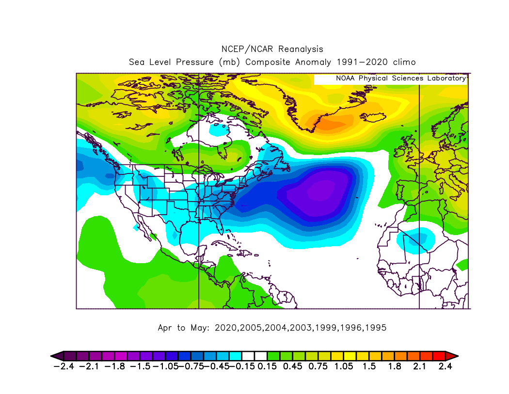
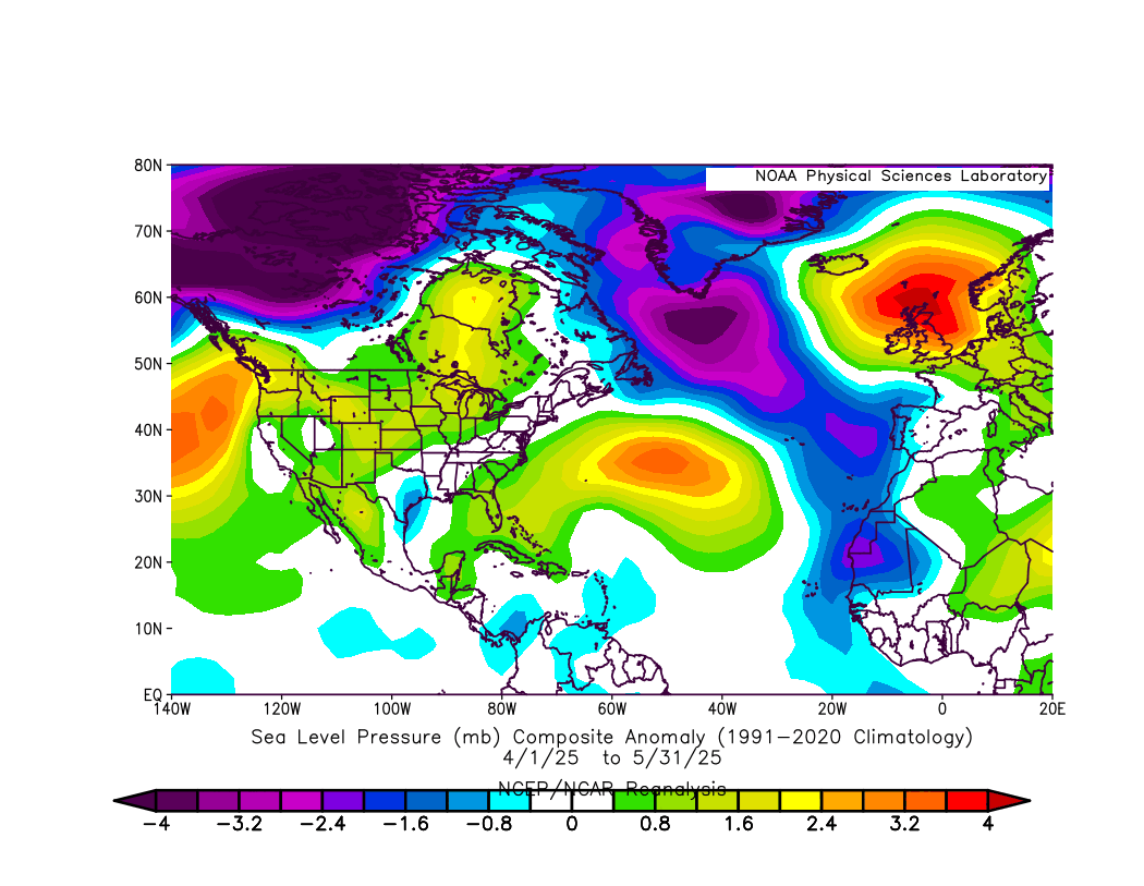
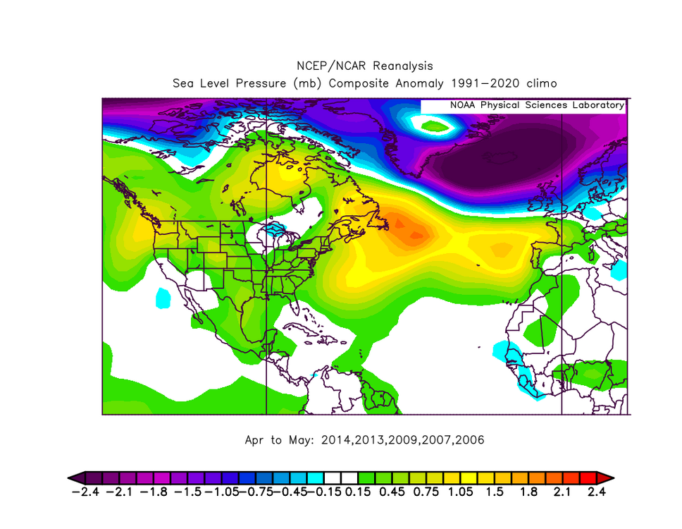
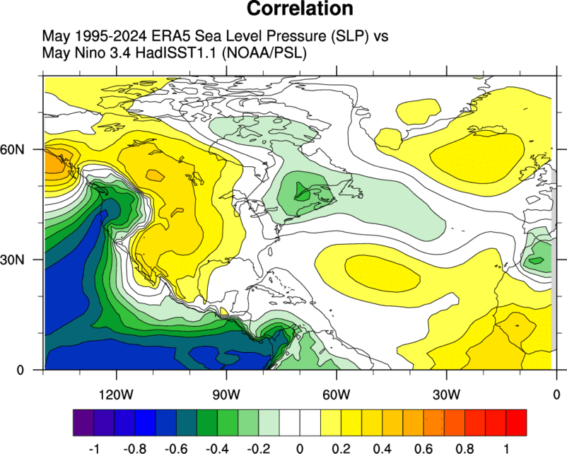
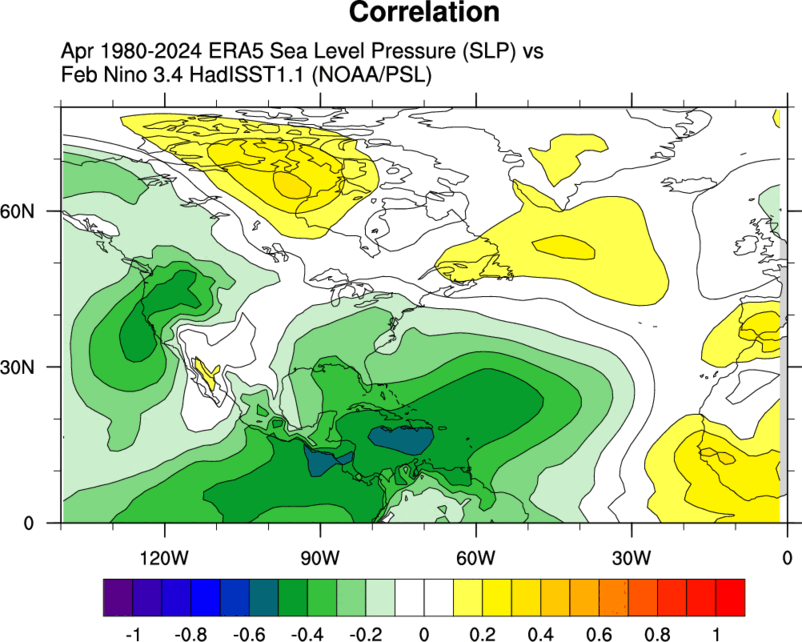
Hi Chuck, Interesting comparisons! I personally think using named storms to characterize active vs. inactive years is not particularly meaningful, given the human subjectivity and changes in NHC criteria over the years in terms of what is named. If we take the years with the most and least ACE since 1995, removing years that were El Ninos in the Apr-May timeframe (since they tend to be strongly correlated with -NAO), here are the most active years: 2020, 2005, 2004, 2003, 1999, 1996, 1995 The least active years: 2014, 2013, 2009, 2007, 2006 This year has some characteristics in common with the least active years (-MSLP anomaly from NW Territories of Canada to Greenland and +MSLP anomaly from the NW US to Hudson Bay and off the coast of the NE US). However, what is different from the inactive year composite, and closer to the active year composite, is the -MSLP from near Newfoundland to the central Atlantic near the Azores and then southward into the far east Atlantic and w. Africa. Additionally, the strong +NSLP from near the UK to Iceland is more similar to the active year composite. In short, a mixed bag, probably closer to inactive years but not a clear signal!


-
1.5" overnight.
-
next heat signal ..maybe the 11-13th
-
2025-2026 ENSO
40/70 Benchmark replied to 40/70 Benchmark's topic in Weather Forecasting and Discussion
Eh....the Xmas event occured later in the Xmas day and was heavily tained with IP for me, and I got crewed in PD II. That winter was good, but left a lot on the table. -
Yes, we had bad winters like 1998-99 during the 1950s too. Winters which lack snow during DJF and deliver a parting shot in March have happened before and will happen again.
-
Yes, nothing annoys me more with winter than having a somewhat snowy winter without a big event as the centerpiece. It's why 2002-03 ranks so high for me, it had snow on Christmas, the big 26 inch PD2 in the middle of winter and a snowstorm to close out the season in April.
-
Another pleasant morning, low of 57.
-
2025-2026 ENSO
40/70 Benchmark replied to 40/70 Benchmark's topic in Weather Forecasting and Discussion
This would have been a slightly cooler shitty winter in 1898-1899...people get carried away with the CC crap. It was a bad pattern, regardless of the warming climate. +WPO/+EPO/+AO+NAO/-PNA/-PDO and a strong modoki La Nina, but sure...lets focus on CC. That season was an instruction manual on how to avert winter in the NE US. -
That storm in February 1983 was my absolute favorite storm growing up, most of the rest of the 80s sucked for snowfall here. February 1983 is what introduced thundersnow into my lexicon lol.
-
CIPS has a bit of a signature for severe around 120hr. One thing I've seen relatively consistently this spring so far is analogs from 1998 being peppered into the mix. That was a really robust spring.
-
Yesterday and today are ideal, I wish we could have this instead of the rainy crap or the high humidity swampiness.
-
it's just one day of clouds and showers though, as opposed to 3-4 days which we don't need or want