All Activity
- Past hour
-
The downside of rainy patterns in the summer are more pests and more spread of infectious disease. I fully expect West Nile and Lyme disease to be rampant this summer because of all this cursed rainfall.
-
we need to start spraying chemicals to eradicate them, even if it means killing off insects
-
I was pointing this out last month. We typically don’t get 40 to 50 days reaching 90° like in 2010 and 2022 without 90°+ heat in May. The summer could still average warmer than normal. But we will probablyhave plenty of onshore flow and moisture.
-
thank you, math heads confuse the definition between warm and hot, the two mean different things. above average does not mean *hot*
-
This is an interesting thought. September has become more summery than June is.
-
I'd rather hot, dry days intermixed with legit below normal days, the way things were. I love the fact that July 1936 that gave us 106 degrees in NYC actually finished below normal, -1.3 by today's fake new normals. 90% of the lows that month were in the 60s and about half the month had lows 65 degrees or lower. Three nights had lows of 60 degrees. There were already 8 million people in NYC in the 1930s, so the UHI was already alive and well at the time. There were more people in NYC in the 1930s then the second biggest city in the USA, L.A., has today in 2025. I HATE high minimums and these digusting higher dewpoints we always have now.
-
But it's not a hot summer either, hot has a specific definition that refers to a high number of 90 and 95 degree days and 100 degree days too. We used to get these frequently in the 40s and 50s, as most of our heat records are from that era (with another peak in the 80s, 90s up to 02.)
-
yes we can call it a warm summer, but hot has a specific definition that refers to extreme temperatures while warm can merely refer to elevated averages from higher mins.
-
yeah this weather will only make more people sick it's why I need to do extensive spraying tick bites for animals are way above normal by the way glad to see you're coming around to my way of thinking that above average temperatures does not mean it's hot. I know it's a nuanced discussion but *hot* has a specific definition and a rainy summer even with +2 temperatures with a low number of 90 and 95 degree days and no 100 degree days is not a hot summer. the whole thing about average temperatures I feel is used to construct a narrative by people that just isn't true and doesn't pass the eye test. And I'm someone who knows full well about and agrees with climate change science. But I know what a hot summer is and above average with lots of rain and a low number of hot days just does not cut it.
-
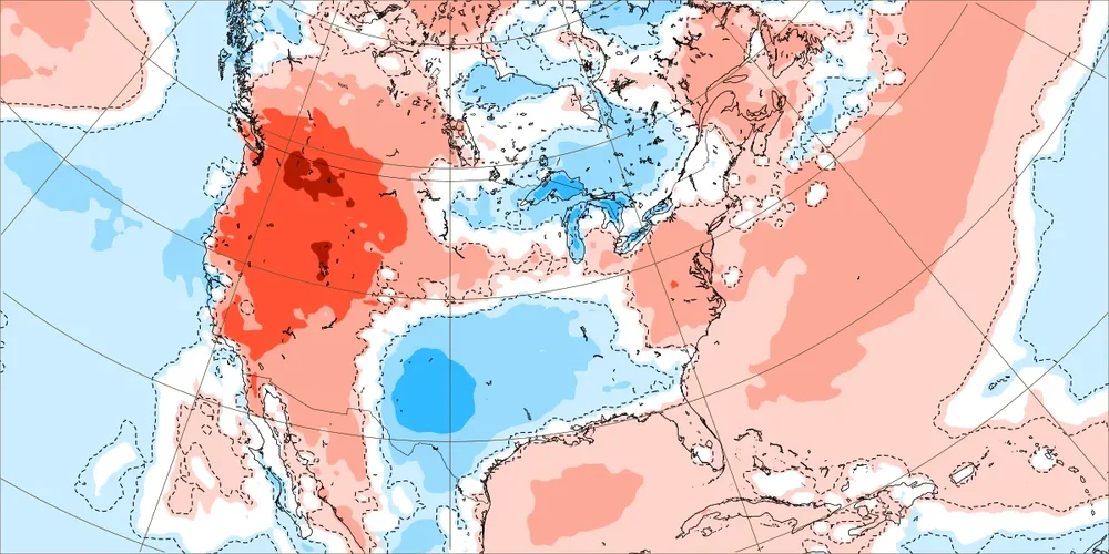
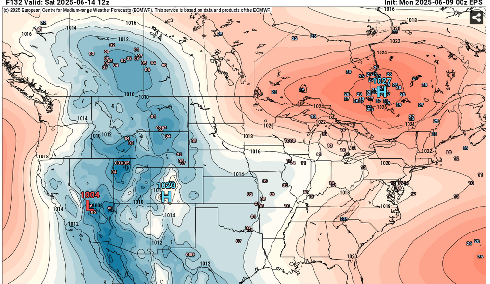
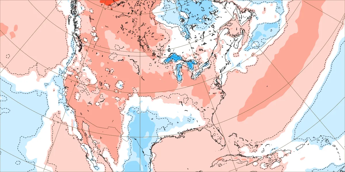
Less warm or closer to the warmest 1991-2020 normals is the new cool. This looks like the pattern for the next few weeks. Perhaps the pattern warms up during the last week of June allowing a modest warm departure for the whole month on average. June 9 to 16 EPS forecast June 16 to 23 forecast

-
EWR: 102 (2011) now this is real heat, not bogus *above average* temperatures that some people confuse with heat
-
above normal doesn't cut it for me, as averages can be elevated without any hot days, just a lot of rain and elevated minima. this is why warm and hot describe completely different things we can be above normal without any hot days or any sunshine for that matter that's not a hot summer.
-
Because of the stunningly stalwart defiance to change (the trend that has never un-trended itself ... ) I'm gonna go ahead and just assume this precarious weekend dong set up of a pattern will go ahead a verify the rape and claim a 14th soul in row ... At this point, we've seen a dozen different modeled reasons to not fuck up a weekend's sensible weather, with a 0-15 W-L record. Sometimes, the trend just has to end per its own unpredictable nature, and it's just a waiting game. That means no matter what outlook says otherwise, the onus in on the trend to stop at all. Because apparently ... there are no scenarios capable of stopping it within the capacity of human technology for detection. So, if you're an operational Met predicting the summer, you forecast all weekends fucked until further notice. Capiche?
-
cool (like today) or warm but definitely not hot. above normal = warm hot = large number of 90 and 95 degree days and a few 100 degree days thrown in. That's how I view warm vs hot. warm describes elevated averages while hot refers to number of hot days (this is how the NWS describes it too). when talking about hot days, elevated minima are not factored in as the word *hot* as a specific definition refers to how high the high temperatures are. the excessive rain is why our number of hot days is down.
-
We have 90% of summer still ahead of us. I will bet we finish above normal by the end of August.
-
Misty misery Monday.
-
I got with a deer tick yesterday. Going on Doxy today. Damn.
-
The radar is amazingly clear for 100% chance of rain.
-
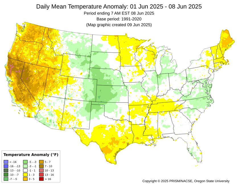
The long range still shows no real extreme heat. Next week might be trending downward with temps as a more Easterly flow may set up. The main heat areas are out West. Precip is never that far away. Granted the actual amounts may vary.
.thumb.png.8f6a0ac8b350094e848b680ade1de055.png)
-
Need
-
Another inch over (Tue) / Sat - Sun.
-
Records: Highs: EWR: 102 (2011) NYC: 97 (1933) LGA: 99 (2008) JFK: 96 (1984) Lows: EWR: 47 (1957) NYC: 47 (1930) LGA: 59 (1980) JFK: 48 (1980) Histrical: 1874:The highest maximum temperature ever recorded in June in Washington, DC was 102 °F. (Ref. Washington Weather Records - KDCA) 1953 - A tornado hit the town of Worcester MA killing ninety persons. The northeastern states usually remain free of destructive tornadoes, however in this case a low pressure system, responsible for producing severe thunderstorms in Michigan and Ohio the previous day, brought severe weather to New Hampshire and central Massachusetts. The tornado, up to a mile in width at times, tracked 46 miles through Worcester County. It mangled steel towers built to withstand winds of 375 mph. Debris from the tornado fell in the Boston area, and adjacent Atlantic Ocea. (David Ludlum) (The Weather Channel) 1966: Hurricane Alma made landfall over the eastern Florida panhandle becoming the earliest hurricane to make landfall on the United States mainland. 1971: The tornado that struck the town of Gruver in the Texas Panhandle on this date is believed to be the widest tornado in U.S. history with an average path width of 2,500 yards. At times, the monster storm was over two miles wide. (Ref. Wilson Wx. History) 1972 - A cloudburst along the eastern slopes of the Black Hills of South Dakota produced as much as 14 inches of rain resulting in the Rapid City flash flood disaster. The rains, which fell in about four hours time, caused the Canyon Lake Dam to collapse. A wall of water swept through the city drowning 237 persons, and causing more than 100 million dollars property damage. (David Ludlum) 1987 - Lightning struck Tire Mountain near Denver CO, destroying two million tires out of a huge pile of six million tires. Thunderstorms spawned three tornadoes around Denver, and a man was killed at Conifer CO when strong thunderstorm winds lifted up a porch and dropped it on him. A thunderstorm near Compton MD produced two inch hail, and high winds which destroyed twenty barns and ten houses injuring five persons. (Storm Data) (The National Weather Summary) 1988 - Thunderstorms produced severe weather from North Carolina to the Central Gulf Coast Region. Hail in North Carolina caused more than five million dollars damage to property, and more than sixty million dollars damage to crops. Hail three and a half inches in diameter was reported at New Bern NC. Thunderstorms in the Central High Plains produced eighteen inches of hail at Fountain CO. The temperature at Del Rio TX soared to an all-time record high of 112 degrees. (The National Weather Summary) (Storm Data) 1989 - Severe weather abated for a date, however, showers and thunderstorms continued to drench the eastern U.S. with torrential rains. Milton, FL, was deluged with 15.47 inches in 24 hours. Record heat and prolonged drought in south central Texas left salt deposits on power lines and insulators near the coast, and when nighttime dew caused arcing, the city of Brownsville was plunged into darkness. (The National Weather Summary) 1993: Lightning struck a US Air Boeing 737 parked overnight at the Buffalo International Airport in New York. The lightning traveled through the plane to the runway and exploded the concrete runway at the three points of the landing gear. The flying concrete debris caused damage to the fuselage and winds of the plane. The 737 had to be ferried out for repairs. In addition to the damage to the plane and runway, power generators connected to the plane overnight were shorted and blown out. (Ref. Wilson Wx. History)
-
Lots of sun this morning after some morning mist. I guess it's supposed to rain again tonight?
-
Sun looks like it's trying to poke out.
-
This map looks familiar from about a month ago. The severe threat was to the river too. But than they expanded it it past the river. They issued severe thunderstorm warnings for me when the thunderstorm was on top of me. So I wonder if the same scenario will occur today, tonight also.


.png.b8d007507926352523d20712fa540f1b.png)


