All Activity
- Past hour
-
The NAM is finally getting replaced after they stop updating it in March 2017. Public Information Statement 25-41 National Weather Service Headquarters Silver Spring, MD 845 AM EDT Thu Jun 26 2025 To: Subscribers: -NOAA Weather Wire Service -Emergency Managers Weather Information Network -NOAAPORT Other NWS Partners, Users and Employees From: Richard Bandy Acting Director NCEP/Environmental Modeling Center Subject: Soliciting Comments on Proposed Discontinuation of the North American Mesoscale (NAM) model and other Regional Modeling Systems to be Replaced by the Rapid Refresh Forecast System (RRFS) through July 26, 2025. The Environmental Modeling Center (EMC) at the National Centers for Environmental Prediction (NCEP) is working towards replacing the North American Mesoscale (NAM) model, the High Resolution Window (HiresW) aside from the Guam domain, the High Resolution Ensemble Forecast (HREF) and the North American Rapid Refresh Ensemble (NARRE) systems with the implementation of the Rapid Refresh Forecast System (RRFS) in early 2026. The NWS is seeking comments on this proposed change through July 26, 2025. This transition to RRFS would provide an hourly updating modeling system over a North America region at 3 km horizontal grid spacing, which, combined with the model retirements, would greatly unify and simplify the “convective scale” (approximately 3 km grid spacing) regional models within the NWS operational modeling suite. As a deterministic system running to 84 h, the RRFS would fully retire the NAM, and nearly fully retire the HiresW (aside from the Guam domain). As an ensemble forecast system, the RRFS Ensemble Forecast System (REFS) would fully retire the HREF and NARRE systems. The deterministic RRFS generates full domain output at 3 km grid spacing, and subset grid output over the contiguous United States (CONUS) and Alaska (AK) (at 3 km grid spacing), and Hawaii (HI) and Puerto Rico (PR) (at 2.5 km grid spacing). The RRFS will also provide output from a separate 1.5 km RRFS fire weather run, with output provided over a 5 x 5 degree rotated latitude longitude region. Details of the RRFS output grids are available in https://www.emc.ncep.noaa.gov/mmb/mpyle/rrfs_info/rrfs_grids.txt Relative differences between RRFS output products and the proposed-to-be- retired system products will be discussed individually by the modeling
-
mowing tomorrow
-
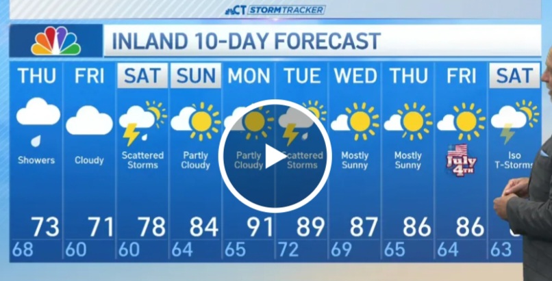
I made a joke about how the Accuweather 90 day forecast showed the hottest it would be here was 83 all Summer.. obviously knew it was wrong and it was to stir all the warmers up but apparently he took it to heart
-
We also had 5 day stretches in both July and August last summer, which I know doesn’t technically negate your statement. The only other time we had 5 day streaks of 90 degree temps in 3 consecutive summer months (not necessarily the same summer) was July and August of 1887 and June of 1888.
-
We’ve been stuck at 63 all day here. Glad to be north of the front. Two days in the 90s was enough for me. Our two day rain total will probably be somewhere around 3” once all is said and done in Minneapolis.
-
remember in one of my post I said we would still get some hot days but yes west and Midwest are best! That Accuweather thing was a joke and cant figure out how you cant figure it out.. If your stuck on that IDK what to tell you
-
He’ll admit it . No need to link
-
Typo. Should have typed 80’s. Ryan fixed Bob’s error . Good job posting 18 hour old maps though! https://imgur.com/a/IDWIMsE
-
Nope. Link?
-
Remember when he said no heat makes it into the northeast and it would stay way southwest? And his Accuwx app even said so? Just forget that call?
-
Nah great snow says everyone is out. What a drunk.
-

E PA/NJ/DE Summer 2025 Obs/Discussion
Violentweatherfan replied to Hurricane Agnes's topic in Philadelphia Region
Nothing for bucks county -
Yep 60s ftl today. Thought it could be a tad warmer. Thankfully this disaster lasts only one more day.
-
BULLETIN - EAS ACTIVATION REQUESTED Flash Flood Warning National Weather Service Binghamton NY 346 PM EDT Thu Jun 26 2025 The National Weather Service in Binghamton has issued a * Flash Flood Warning for... Central Lackawanna County in northeastern Pennsylvania... * Until 645 PM EDT. * At 346 PM EDT, Doppler radar indicated thunderstorms producing heavy rain across the warned area. Between 1 and 2 inches of rain have fallen. Additional rainfall amounts up to 1 inch are possible in the warned area. Flash flooding is ongoing or expected to begin shortly. HAZARD...Flash flooding caused by thunderstorms. SOURCE...Radar. IMPACT...Flash flooding of small creeks and streams, urban areas, highways, streets and underpasses as well as other poor drainage and low-lying areas. * Some locations that will experience flash flooding include... Scranton, Dunmore, Dickson City, Olyphant, Clarks Summit, Clarks Green, Elmhurst, Mount Cobb, Taylor, Throop, Glenburn and West Scranton.
-
You better tell your friend Bob.
-
Is DIT really 61/54 right now at 4pm? Yikes. 73/53 up here.
-
Hopefully the rains stay up at the Canadian border this weekend. The Lakes and white MTNs region hasn't had the revenue they normally would by this point.
-
95/74/106 currently. Should have been some sort of heat advisory/warning today. My HI has been at or above yesterday's all afternoon. MU also at 95.
-
He was right!
-
Rain has arrived in Eau Claire, its cloudy and 67, a few days ago it was 97.
-
i wonder if that has to do with the slower/further north jet resulting in these crappy shallow fropas
-
I'm driving at the moment. You can't check but something out. There is going gangbusters at the moment.
-
I'm picking up on abnormally, powerful strokes on my am radio frequency at the moment
-
It’ll be 80’s Saturday here . Wasn’t talking about rains in Maines


.thumb.jpg.6a4895b2a43f87359e4e7d04a6fa0d14.jpg)