All Activity
- Past hour
-

December 2025 Short/Medium Range Forecast Thread
Carvers Gap replied to John1122's topic in Tennessee Valley
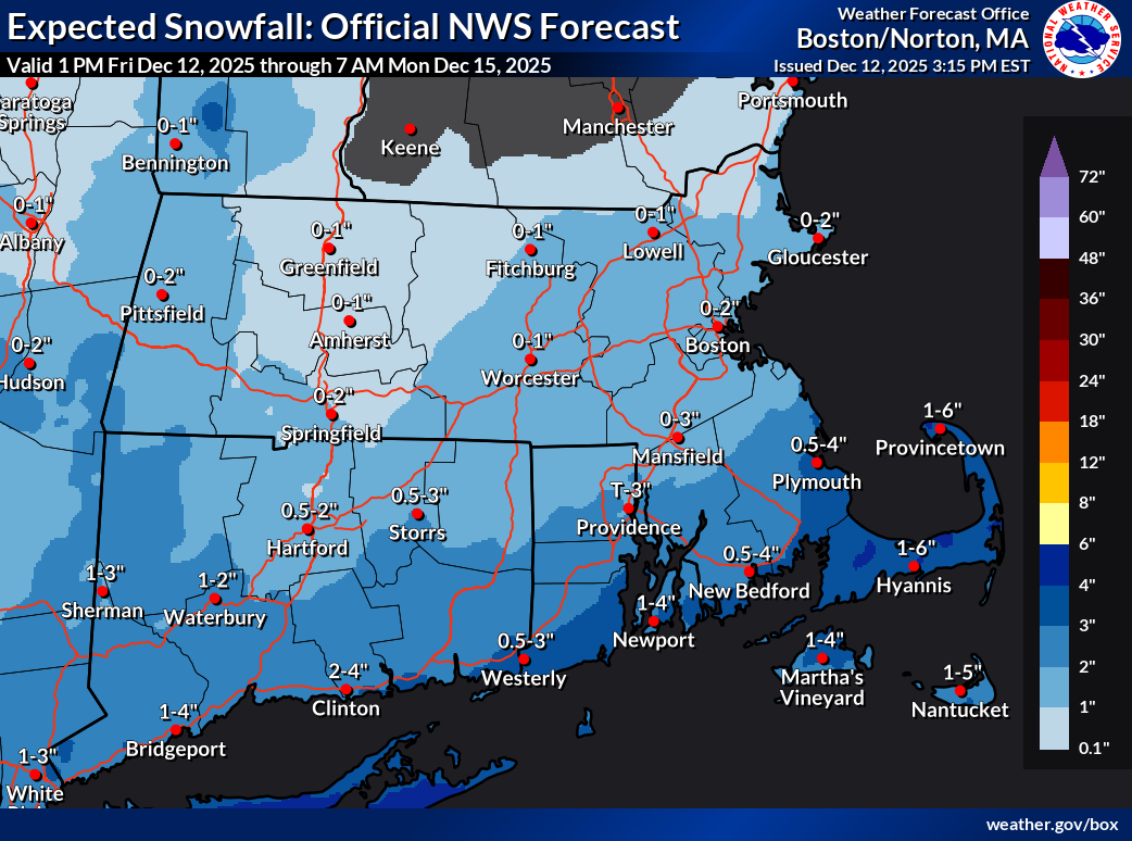
MRX graphic from social media. Feel free to post your local. -
It just gets started a little too late... just like most of our transfers
-

December 14th - Snow showers or Plowable snow?
ORH_wxman replied to Sey-Mour Snow's topic in New England
We’ll need slight nudges north almost every cycle from here on out to get solid advisory amounts more than 25 miles north of the south coast. Your area might not need quite as many nudges. -
December 2025 Short/Medium Range Forecast Thread
Carvers Gap replied to John1122's topic in Tennessee Valley
Yeah, it's just December 11th. Today's Euro Weeklies control flips the pattern back during the second week of January. IF we can pull that off, we have cold during the coldest weeks of the year. The warm solutions(and they are WARM) in ensembles are skewing the mean. For example, there might 14/25 members which are BN with temps, but the other 11 are raging warm. The mean would be well AN, but the median might be cold. I have always been taught that reality subtracts (as we get closer) the less likely members, and the more likely members are left. Do I think we see some warm-ups this winter? Absolutely, and models are honking at some chinook warmups Between Dec 20th and Jan 8th. That is a pretty normal time for a thaw. Nina winters really like to pull the trough back West for about 2/3 of winter, but the 1/3 we get can often be good. I don't see a thing which surprises me at this point. That said, I am not sweating AN temps when we have very cold temps on the way Sunday and Monday. I truly need about 7-10 days to warm-up. The cold in NE TN has been pretty relentless. -
As of this past August. I don't feel it.
-

December 14th - Snow showers or Plowable snow?
TauntonBlizzard2013 replied to Sey-Mour Snow's topic in New England
Too bad, there’s some stronger stuff just offshore on the RGEM, talking 50-75 miles to get a solid advisory event for many. But it def regressed here. 4-5” at 12z became 2-3” at 18z -
Appalachians, precipitation will struggle to make progress to the east of the Allegheny Front for several hours. As the wave amplifies and approaches from the west, most models show a jet steak developing downstream, with forcing for ascent increasing within the equatorward entrance of the jet streak. Most solutions show the jet entrance region lining up right along I-95. Ascent within the jet entrance region may cause precipitation to jump eastward and develop in-situ along the I-95 corridor, largely skipping locations between the Allegheny Front and Blue Ridge. Precipitation within the jet entrance region to the east of the Blue Ridge is expected to blossom during the mid-late evening hours, and then slowly drift southeastward through the remainder of the night. The precipitation may begin as a brief period of rain or mixed rain and snow, especially along and southeast of the I-95 corridor. This mix should be short-lived however, as much colder air rushes in behind an Arctic front that will move through over the course of the night. In terms of timing, some light precipitation could begin as early as the mid-late evening hours, but the bulk of the precipitation along the I-95 corridor is expected to occur between roughly 11 PM and 7 AM. The band that will develop will be a relatively narrow feature, and will feature moderate to heavy snow at times. Snowfall rates within the band could near or potentially briefly exceed one inch per hour at times late Saturday night. With a narrow feature producing heavy precipitation, snow totals will be heavily dependent on the ultimate placement of this band. This, combined with the potential for a bit of mixing with rain at onset makes for a challenging snowfall forecast. Probabilistically speaking, 12z guidance has focused in on the I-95 corridor from DC northeastward, and then eastward along US-50 toward the Chesapeake, with northeast Maryland southward toward Annapolis having the greatest probabilities for higher totals. As of this moment, a broad 1-4 inches from the vicinity of the I-95 corridor eastward appears like the most likely scenario, with embedded maxes of 4-7 inches possible where the band resides for the longest time period. Since there will be very sharp snowfall gradients on the edges of this band, and there`s still a bit of uncertainty with respect to where this band will be, we`ve decided to hold off on issuing headlines to the east of the Blue Ridge for the time being. Headlines will almost certainly be needed eventually, and we`ll continue to assess trends and refine the forecast through the remainder of the day. Snow will end from northwest to southeast a few hours either side of daybreak, with the back edge of the snow clearing southern Maryland by around mid-morning. Strong cold air advection is expected behind the Arctic front through the day Sunday, with 850 hPa temperatures crashing to around -15 to -20 C by peak heating. This will cause temperatures to drop through the 20s over the course of the day. Northwesterly wind gusts to around 35 mph will make it feel even colder, pushing wind chills into the single digits and teens. After the snow moves out, dry conditions are expected to the east of the mountains. Upslope snow showers will linger in the Alleghenies over the course of the day. Cold and windy conditions will continue through Sunday night, with cold weather headlines likely being needed for portions of the area. &&
-

December 14th - Snow showers or Plowable snow?
bristolri_wx replied to Sey-Mour Snow's topic in New England
Did the person who does snowfall map ranges at BOX get shit-canned during the shut down? The ranges are noticably odd this year. Never saw 0" for the low range in the past with any number other than 1" as the top end of that range. Usually it was shown as < 1".Still appreciate the maps are published but it just makes my brain hurt to see things like 1-6"...
-
December 14th - Snow showers or Plowable snow?
TauntonBlizzard2013 replied to Sey-Mour Snow's topic in New England
Yeah definitely looks worse than 12z, especially SE Mass, good never real get past canal -
December 14th - Snow showers or Plowable snow?
ORH_wxman replied to Sey-Mour Snow's topic in New England
Rgem looked a little skimpier but pretty close to 12z. Icon came north like the NAM did so that was the two most suppressed models at 12z coming north and the juiciest one slightly nudging S (or at least less QPF)…so there is some model convergence going on. -

12/14: Sunday funday? Will the south win again?
Imgoinhungry replied to TSSN+'s topic in Mid Atlantic
Make this come true, you must. In my best yoda voice. . -

December 14th - Snow showers or Plowable snow?
weathafella replied to Sey-Mour Snow's topic in New England
Recalculating…40? -

12/14: Sunday funday? Will the south win again?
NorthArlington101 replied to TSSN+'s topic in Mid Atlantic
WxBell crawls for GEM maps so not yet. AFD is out btw - holding on advisories. I’ll let you copy paste -
I feel like one must not only actually be and remain a New Englander but also pay the tithe that is spending dry summer days talking about nothing here in order to have that kind of status. Always a Mid-Atlantic transplant from the start, the reality is that at best I've become one of those "church, but only on Christmas and Easter" types or its equivalent for this forum. But, when it's snowing up there, and raining where I am -- as it so often is -- I look to the northeast of me, which is where you all are now, and give a contented nod. I hope you feel it. Do you feel it?!
-
@NorthArlington101 do you have the closeup version? This is the closest PW gets
-
.thumb.png.4150b06c63a21f61052e47a612bf1818.png)
December 2025 regional war/obs/disco thread
HIPPYVALLEY replied to Torch Tiger's topic in New England
Major ice storm set ups are tenuous at best. 1998 had a low stalled out over the lakes and high pressure in just the right place in Quebec. That’s what allowed a good fetch of gulf moisture to ride into the Arctic air for days., -

Saturday night/Sunday 12/13-12/14 Jawn
Ralph Wiggum replied to Ralph Wiggum's topic in Philadelphia Region
RGEM is another nice hit -
Had graupel as well, didn't know what it was at first. Looked like bits of styrofoam coming from the sky.
-

December 14th - Snow showers or Plowable snow?
SouthCoastMA replied to Sey-Mour Snow's topic in New England
Should hold serve, at least? Although the mid-levels look a hair south despite the better tilt Yeah, cut back slightly past the canal. A better oriented TPV won't matter if its being shunted further SE faster. -
We all take
-

Minor snow possible sunday 12/14/25
jm1220 replied to WeatherGeek2025's topic in New York City Metro
Looking at the soundings, looks like a deep layer of saturation that should support decent snow growth. If we play everything right, maybe close to a warning event especially just east of my area. Port Jefferson to around Riverhead is usually good in these. -
December 14th - Snow showers or Plowable snow?
TauntonBlizzard2013 replied to Sey-Mour Snow's topic in New England
I’m at 42 and it does look a bit better oriented -
Its not heavy snow... but a good 6 to 8 hours of snow across most of the region on the 18z RGEM
-
12/14: Sunday funday? Will the south win again?
NorthArlington101 replied to TSSN+'s topic in Mid Atlantic
RGEM holds -
December 14th - Snow showers or Plowable snow?
SouthCoastMA replied to Sey-Mour Snow's topic in New England
thought the TPV looked better tilted at 36 to me..but we'll see how it pans out.

.thumb.jpeg.1d2958065f007d9e7218a8c935ea8246.jpeg)