All Activity
- Past hour
-

E PA/NJ/DE Winter 2025-26 Obs/Discussion
Duca892 replied to LVblizzard's topic in Philadelphia Region
Taking a combo of everything I would put it out there that the Lehigh Valley area is maybe in the 1-2in range with maybe 2-4in around Philly. Not that amped about this after half decent trending yesterday. EURO absolutely refusing to budge blows hard -

“Cory’s in NYC! Let’s HECS!” Feb. 22-24 Disco
ineedsnow replied to TheSnowman's topic in New England
Someone seems interested now -

“Cory’s in NYC! Let’s HECS!” Feb. 22-24 Disco
The 4 Seasons replied to TheSnowman's topic in New England
Yep thats not even debatable since 22-23 was 01-02 level bad. 23-24 and 24-25 were also dog shit winters that didn't even crack 20" here. 21-22 was the last OK (at best) winter across the region. -
“Cory’s in NYC! Let’s HECS!” Feb. 22-24 Disco
The 4 Seasons replied to TheSnowman's topic in New England

- Today
-

Feb 22nd/23rd "There's no way..." Storm Thread
Weather Will replied to Maestrobjwa's topic in Mid Atlantic
WB 6Z NBM para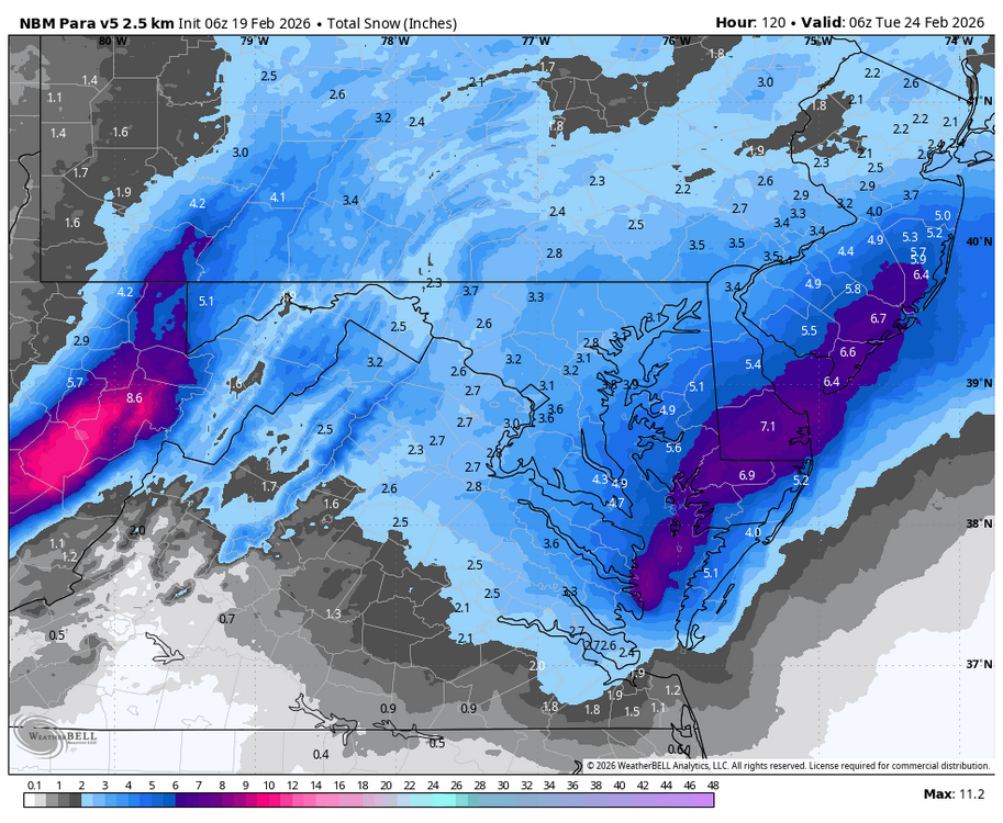
-
“Cory’s in NYC! Let’s HECS!” Feb. 22-24 Disco
The 4 Seasons replied to TheSnowman's topic in New England
don't do it -

“Cory’s in NYC! Let’s HECS!” Feb. 22-24 Disco
CoastalWx replied to TheSnowman's topic in New England
Both ai and eps ensemble west of 18z. -

E PA/NJ/DE Winter 2025-26 Obs/Discussion
Newman replied to LVblizzard's topic in Philadelphia Region
These are excellent trends on the last 4 GEFS runs. We need to continue to see these ticks or at least a hold over the next day or two. A big thing is that ULL off the West Coast which needs to keep backing up off the coast to allow the downstream ridge to back west as well. More spacing between our 50/50 and East Coast trough too is a good look.
-
“Cory’s in NYC! Let’s HECS!” Feb. 22-24 Disco
ineedsnow replied to TheSnowman's topic in New England
Last few model runs have shown a more amplified downstream ridge and have thus trended back northwest with a potentially very powerful coastal storm Sun night into Mon. That being said, these trends moreso serve to underscore the run-to-run variability as this is a Day 4-5 forecast, which is an eternity in the model world. If these trends continue as much of the guidance suggests, then there may be a period of perhaps significant impacts Sunday night into Monday. Plenty of time here and the model trends will be very important over the next 48 hours. Not much more we can say at this point, but it is way too early to write this one off and it still bears watching. -
thanks. saw it did very good on the Jan 25-26th storm, just curious about it. too many models..
-
Slightly west of 18z
-

“Cory’s in NYC! Let’s HECS!” Feb. 22-24 Disco
George001 replied to TheSnowman's topic in New England
Euro AI is back on board for a major storm. If the regular Euro and EPS jump on board tomorrow that would be huge. Hopefully we can get a big bump west, big 12z runs coming up. -
It’d be pretty wild if we reeled this in, in any capacity this late in the game. Let’s see if trends continue tomorrow or we see models bounce back toward their original solution. 95 east should for sure should be intrigued at the very least
-
“Cory’s in NYC! Let’s HECS!” Feb. 22-24 Disco
George001 replied to TheSnowman's topic in New England
I didn’t word that great, I disagree with picking and choosing that it sucks vs is good depending on how much snow it shows. Picking and choosing because certain models are better in certain setups or you are seeing something in the large scale pattern that favors a certain outcome…. Yeah that’s good forecasting. I’m criticizing doomcasting, not what you are doing. Wanting the Euro suite to stabilize as a hit before buying in is reasonable. My issue is with the side with the models that show the least snow process (imo a lot of people have overcorrected due to recent lean years). Again, you aren’t doing that, and honestly I don’t disagree with you. I’m not on the blizzard train myself. I’m not ruling it out, but gun to head I’d favor a glancing blow. Once the Euro stabilizes and what solution it locks on to will be very telling. -
What exactly does Weathernext2 show and where do you see it?
-
Wednesday Feb 18 Mixed event. NOPE …ain’t happenin’
The 4 Seasons replied to HoarfrostHubb's topic in New England
Good news is i wont have to do a map for this stupid event did anyone in CT even get measurable? We'll find out tomorrow, im sure Norfolk 2SW got a half inch somehow. -

Feb 22nd/23rd "There's no way..." Storm Thread
Roger Smith replied to Maestrobjwa's topic in Mid Atlantic
Was that last weekend? I always think of PD storms as being around Feb 20th and I am not that familiar with how various states celebrate the occasion. Will have to read up on it. Just finished reading up on it, apparently Washington's actual birthday adusted to the Gregorian calendar was Feb 22nd (1732) but the holiday falls on the third Monday in February in most states (not all). Lincoln's birthday was February 12th, 1809 So this storm could be labelled Washington's Birthday Blizzard although it won't likely start until the early morning of the next day. Anyway now I know a lot more about Presidents' Day, and apparently one of the few states that does not observe the holiday is Delaware. -

Feb 22nd/23rd "There's no way..." Storm Thread
Maestrobjwa replied to Maestrobjwa's topic in Mid Atlantic
It would have to happen on President's day weekend...hence the PD abbreviation, lol -
Feb 22nd/23rd "There's no way..." Storm Thread
Roger Smith replied to Maestrobjwa's topic in Mid Atlantic
Could this be designated PD-3 (or PD-III) if it proves to be a heavy snowstorm anywhere in the east coast region? Or would that happen after the fact only? -
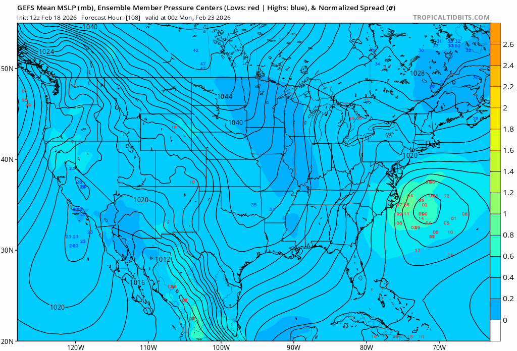
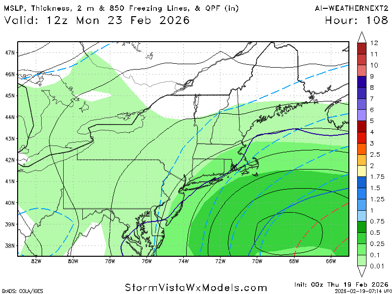
It's an outlier within that group, but it belongs in that group relative to the other 3, as it's much closer to the CMC/AIFS on track and having at least significant snowfall, especially at the coast.
-
The GFS op is definitely an outlier with the ridiculous amount of snow it’s showing in southern NJ, Delmarva, Maryland. No other model shows anything even remotely close
-
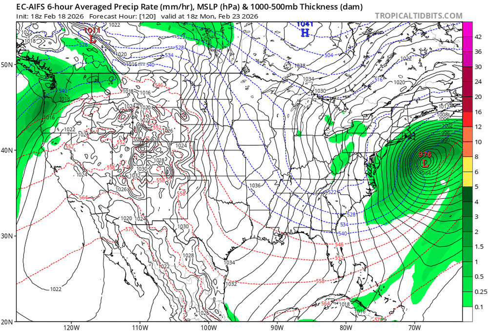
Model Mayhem continues. So, at 0Z, the Euro/UK/ICON all have the surface low move ENE from Cape Hatteras with very robust precip fields (with snow on the NW side of those fields) that are just too far SE to do much for people who live on land, while the GFS/CMC/AIFS/Weathernext2 have surface lows that move ENE from about Norfolk, 100+ miles N or Hatteras, with robust precip fields which are close enough to land to put down a lot of snow at the coast and lesser amounts as one goes inland. Which camp do I believe? No idea, but I will say that the fact that the 0Z Euro ensemble mean is well NW of the Op Euro tells me that the Op Euro has a decent chance of being a bit of a SE outlier and that it should move NW and show more snow. If that were the case, that would tip the balance towards a snowier solution, IMO, since right now, the two best models (Euro-AIFS and Euro-Op) are in different camps.
-
Oh yeah the mean went up on the EPS and AIEPS with several big hits in there about 8-10 on the EPS
-

Central PA Winter 25/26 Discussion and Obs
MAG5035 replied to MAG5035's topic in Upstate New York/Pennsylvania
This has actually been the most consistent part of forecasting this the last couple days, the inverted trough/NORLUN feature plus the general lighter snows having to do with the upper level feature dropping through. The last couple model runs have been fairly consistent across the board with delivering a light to moderate snowfall. The 0z suite is solid in C-PA, Euro included, with ensemble support for such things. What is still wildly different is the evolution of the coastal itself. 0z GFS threw down like 30” on a big part of the Delmarva, while the 0z Euro has 1-2” at best there and way offshore with the developing coastal. -
you have some weenievista maps, wxbell isn't out yet