All Activity
- Past hour
-
-
Yeah, Jamaica is probably fucked.
-
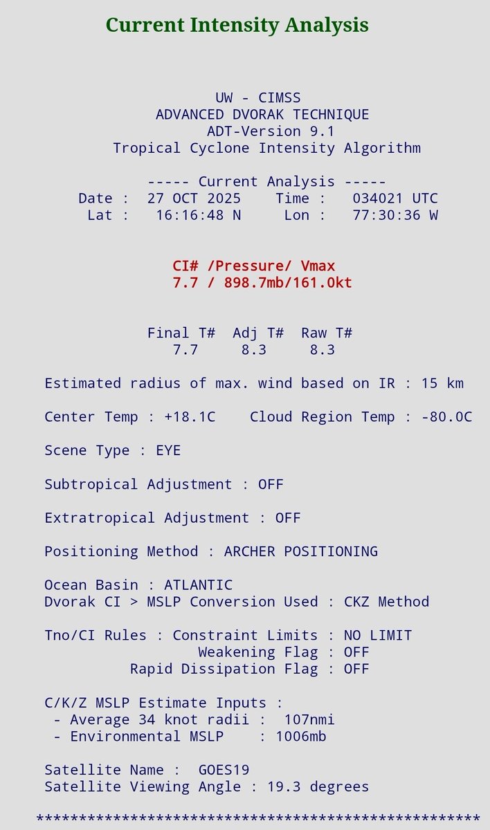
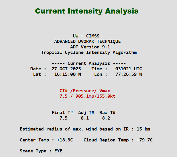
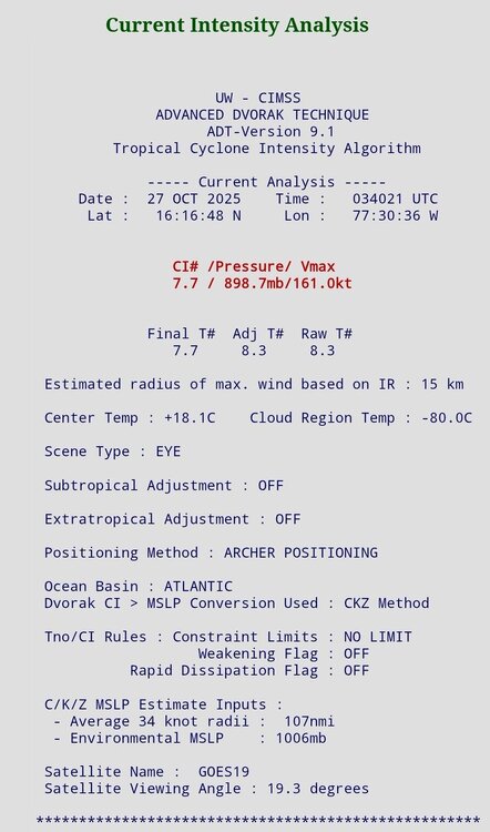
Granted, Melissa's ADT is stronger than ETA's ever was. I think Eta got down to around 918 hPa on ADT, but recon found it to be 10 mb higher. Thus, it never achieved Cat 5. Eta was also embedded inside of a WCARIB surface trough. Melissa's pressure regime is a little higher. So if it is indeed found by recon to be pushing the 910s or 900s hPa tonight, the gradient should support 140+ kt surface winds. But, yes, it would be surprising if ADT busted that hard again.
-
-
The only possible saving grace right now is that the satellite hasn’t matched observations, but idk how much longer that can hold.
-
There are 3 Atlantic basin hurricanes on record on this date or later that were cat 5 and they had these lowest pressures/highest sustained winds: -Mitch of 1998: Oct 26-28; 905 mb/180 mph; but landfall was way down at 80 mph on Honduras. The extreme rainfall though was what made it so deadly. -Hattie of 1961: Oct 31; 914 mb/165 mph; it weakened slightly at landfall in Belize to 915 mb/150 mph (cat 4) -Cuba hurricane of 1932: Nov 5-8; 915 mb/175 mph; but it weakened some before hitting land as it was 150/cat 4 on landfall The latest on record cat 5 landfall was on Cuba on Oct 19 (in 1924) near its peak intensity of 165 mph. So, IF this were to hit Jamaica as a cat 5, it would become the latest on record to make landfall anywhere by 9 days.
-
Imagine this turns out to be another Eta situation where recon gets in there and it’s hasn’t changed intensity. Not saying it will but would be really funny
-
-
The manager hath been chosen

-
Looks like a cat 5 now.
-
Seeing a classic example of what deep oceanic heat content can support. Melissa has been barely moving the past six hours. More or less a drift W-WSW with wobbles. Yet the satellite presentation has continued to improve. The eyewall is cooling the immediate shallow layer, but instead of upwelling driving down heat support, upwelling is mixing up water that is still above the threshold to support Melissa's MPI. The 26°C isotherm is very deep in this part of the Atlantic. Somewhere between 100 and 150 meters. Interestingly, if Melissa did remain stalled for several days, it would eventually cool and mix down SSTs enough to begin impeding its MPI, and would eventually start to weaken. Unfortunately, timing is such with the trough to begin lifting Melissa's core north back over untapped deep OHC. So I don't think SSTs are going to be a caveat for a powerful TC weakening into landfall. We'll have to look at other dynamics for such, like the onset of fast ERC or structural changes. In other words, Melissa may still have enough time to attain Category 5 status and make landfall as a Category 4. But the differences here are pretty moot points. Despite the potential devastation at the location of landfall for the eye, the still bigger life-threatening event here remains the incredible rainfall totals over the south sloping ridges of Jamaica. Landslides and mudflows are killers.
-
You should probably hire a marriage counselor.
-
T 8.0 showing up?
-
The gravity waves are pretty cool
-
They looked like a bunch of wet floor signs--and consequently they slipped over the Packers
-
catastrophiccravings @
-
Impressive explosion of the pink colder colors. Starting to see those outflow striations.
-

Spooky Season (October Disco Thread)
TauntonBlizzard2013 replied to Prismshine Productions's topic in New England
Some know. -
Didn't he make the same prediction last year?
- Today
-
Melissa on that bad bitch status. Go to fucking work!
-
I’m afraid the window of ERC is over. The fact it underwent the MERC earlier today was just bad timing all around for Jamaica. At some point tonight or tomorrow, when Melissa turns north, coastal friction will induce intensification that will also cause Melissa’s eye to contract and tighten. This will prevent an ERC on landfall approach.
-
-
Probably perfect timing. This is peaking in satellite appearance. We’ll see if observational data concurs. Unless there’s a slow ERC or this ticks further west or east than expected, I am finding it increasingly hard to believe there won’t be a category five strike.
-
At first glance at sat imagery (if I knew nothing else) I'd have guessed it's a cat 5. Perfect symmetric buzzsaw that is the CDO.